Reedy Creek (West Virginia) facts for kids
Quick facts for kids Reedy Creek |
|
|---|---|

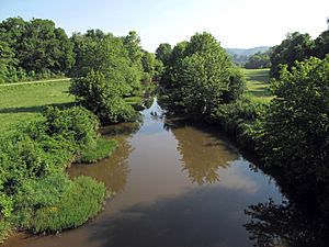
Reedy Creek in Wirt County in 2010
|
|

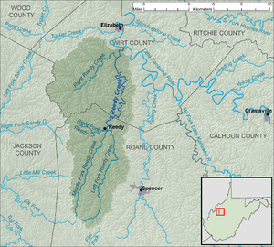
Reedy Creek and its watershed
|
|
| Country | United States |
| State | West Virginia |
| Counties | Roane, Wirt |
| Physical characteristics | |
| Main source | Left Fork Reedy Creek western Roane County 1,014 ft (309 m) 38°45′17″N 81°28′26″W / 38.754811°N 81.4740114°W |
| 2nd source | Right Fork Reedy Creek northwestern Roane County 979 ft (298 m) 38°54′42″N 81°30′30″W / 38.9117504°N 81.5084561°W |
| River mouth | Little Kanawha River Palestine, Wirt County 607 ft (185 m) 39°01′53″N 81°23′25″W / 39.0314692°N 81.3903976°W |
| Length | 22.6 mi (36.4 km) |
| Basin features | |
| Basin size | 133 sq mi (340 km2) |
| Tributaries |
|
Reedy Creek is a river in western West Virginia, United States. It flows into the Little Kanawha River. From there, its waters join the Ohio River and then the mighty Mississippi River. This means Reedy Creek is part of the huge watershed of the Mississippi River.
The creek is about 22.6 miles (36.4 km) long. If you include its longest starting branch, the Left Fork, it stretches to about 38.5 miles (62.0 km). It helps drain an area of 133 square miles (340 km2) in a countryside part of the Allegheny Plateau.
Contents
Where Does Reedy Creek Begin?
Reedy Creek officially starts in the town of Reedy. This town is in northern Roane County. The main creek forms when two smaller streams, called forks, meet up. These are the Left Fork and the Right Fork.
The Left Fork Reedy Creek
The Left Fork Reedy Creek is the longer of the two main starting branches. It is about 15.9 miles (25.6 km) long. This fork begins in the western part of Roane County. Its source is about 7 miles (11 km) southwest of Spencer. The Left Fork flows mostly north, passing through a community called Billings.
The Right Fork Reedy Creek
The Right Fork Reedy Creek is shorter, measuring about 4.7 miles (7.6 km) long. It starts in the northwestern part of Roane County. This fork generally flows towards the west before joining the Left Fork.
Reedy Creek's Journey to the Little Kanawha River
After the Left and Right Forks meet in the town of Reedy, the main part of Reedy Creek begins its journey. It flows mostly north into Wirt County. Along its path, it passes through the community of Lucille.
The creek eventually flows into the Little Kanawha River. This happens from the south in the community of Palestine. For much of its length, West Virginia Route 14 runs alongside Reedy Creek.
Other Important Streams Joining Reedy Creek
Reedy Creek has other smaller streams that flow into it. Some of these are also named after Reedy Creek itself.
Middle Fork Reedy Creek
The Middle Fork Reedy Creek is about 12.4 miles (20.0 km) long. It is a branch of the Left Fork. This stream starts in western Roane County. It flows generally north-northeast, passing through Peniel. It joins the Left Fork in the town of Reedy. This meeting point is about 0.3 miles (0.48 km) upstream from where the Left Fork meets the Right Fork.
Right Reedy Creek
Right Reedy Creek is about 8.3 miles (13.4 km) long. It forms at the community of Peewee in southwestern Wirt County. It is created when two streams, Enoch Fork (3 miles (4.8 km) long) and Fulls Fork (3.4 miles (5.5 km) long), join together. Right Reedy Creek then flows northeastward. It flows into the main Reedy Creek from the east. This happens about 2 miles (3.2 km) upstream from where Reedy Creek meets the Little Kanawha River.
What is the Land Around Reedy Creek Like?
The land area that Reedy Creek drains is called its watershed. According to the West Virginia Department of Environmental Protection, most of this watershed is covered by forests. About 79% of the land is forested, and most of these trees are deciduous (meaning they lose their leaves in the fall). The remaining 20% of the land is used for pasture and agriculture, where crops are grown or animals graze.
 | Jackie Robinson |
 | Jack Johnson |
 | Althea Gibson |
 | Arthur Ashe |
 | Muhammad Ali |

