Reeth Bay facts for kids
Quick facts for kids Reeth Bay |
|
|---|---|
 Reeth Bay |
|
| Civil parish |
|
| Ceremonial county | |
| Region | |
| Country | England |
| Sovereign state | United Kingdom |
| EU Parliament | South East England |
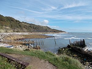
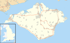
Reeth Bay is a small, curved bay located on the very southern tip of the Isle of Wight, England. It's like a gentle curve in the coastline.
This bay is found south of the village of Niton. Its shoreline stretches for about a quarter of a mile. Reeth Bay faces directly south, looking out into the wide English Channel. It sits just east of the famous St. Catherine's Point lighthouse.
The bay is part of a tiny village called Castlehaven. Here, you'll find a concrete ramp. This ramp is useful for launching small boats into the water. The beach itself is a mix of sand and pebbles, perfect for exploring. Under the water, the seabed is made up of rocks and mud. The easiest way to reach Reeth Bay is by following the road from Niton that leads right down to the shore.
A Look Back: Reeth Bay's History
Reeth Bay has an interesting past. There's a lifeguard cottage at the bay that dates back to the 1800s. Imagine a time when lifeguards helped people swim safely!
Victorian Fun at the Beach
Long ago, during the Victorian era (when Queen Victoria ruled, from 1837 to 1901), Reeth Bay was a very popular spot for tourists. People would come from all over to enjoy the seaside.
Back then, they used something called bathing machines. These were small, wheeled huts. People would go inside the hut, change into their swimming clothes, and then the machine would be rolled into the water. This allowed people to enter the sea privately. It was a very different way to go swimming!
Fishing Boats at Puckaster
Close by, at a place called Puckaster, there used to be a slipway. This was a ramp that faced east. It was used by fishing boats to launch into the sea and bring in their catch. This shows that the bay was also important for local fishing.


