Regina, Minneapolis facts for kids
Quick facts for kids
Regina
|
|
|---|---|
|
Neighborhood
|
|

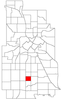
Location of Regina within the U.S. city of Minneapolis
|
|
| Country | United States |
| State | Minnesota |
| County | Hennepin |
| City | Minneapolis |
| Community | Nokomis |
| City Council Ward | 8 |
| Area | |
| • Total | 0.299 sq mi (0.77 km2) |
| Population
(2020)
|
|
| • Total | 2,331 |
| • Density | 7,796/sq mi (3,010/km2) |
| Time zone | UTC-6 (CST) |
| • Summer (DST) | UTC-5 (CDT) |
| ZIP code |
55407, 55409
|
| Area code(s) | 612 |
| Historical population | |||
|---|---|---|---|
| Census | Pop. | %± | |
| 1980 | 2,550 | — | |
| 1990 | 2,474 | −3.0% | |
| 2000 | 2,489 | 0.6% | |
| 2010 | 2,292 | −7.9% | |
| 2020 | 2,331 | 1.7% | |
Regina is a neighborhood located in Minneapolis, Minnesota. It is part of the larger Nokomis community. Neighborhoods are smaller areas within a city, often with their own unique feel and local groups.
Contents
About Regina Neighborhood
Where is Regina Located?
The Regina neighborhood has clear borders. To the north, it is next to 42nd Street. Chicago Avenue forms its eastern edge. To the south, you will find 46th Street. On the west side, it is bordered by Interstate 35W.
How Regina is Governed
Regina is part of a local government area called Ward 8. A "ward" is like a district that elects someone to represent them in the city government. The person who represents Ward 8 is called a Council Member. Currently, Andrea Jenkins is the Council Member for this area.
Neighborhood Organizations
Regina works together with two other nearby neighborhoods: Field and Northrop. They have a shared group called the Field Regina Northrop Neighborhood Group (FRNNG). This group helps residents work together on local projects and improve their community.
 | James B. Knighten |
 | Azellia White |
 | Willa Brown |

