Remington, Virginia facts for kids
Quick facts for kids
Remington, Virginia
|
||
|---|---|---|

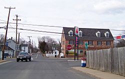
Central Remington
|
||
|
||

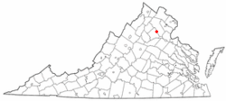
Location of Remington, Virginia
|
||
| Country | United States | |
| State | Virginia | |
| County | Fauquier | |
| Area | ||
| • Total | 0.22 sq mi (0.57 km2) | |
| • Land | 0.22 sq mi (0.57 km2) | |
| • Water | 0.00 sq mi (0.00 km2) | |
| Elevation | 272 ft (83 m) | |
| Population
(2010)
|
||
| • Total | 598 | |
| • Estimate
(2019)
|
658 | |
| • Density | 3,004.57/sq mi (1,159.28/km2) | |
| Time zone | UTC−5 (Eastern (EST)) | |
| • Summer (DST) | UTC−4 (EDT) | |
| ZIP code |
22734
|
|
| Area code(s) | 540 | |
| FIPS code | 51-66512 | |
| GNIS feature ID | 1499948 | |
Remington is a small town located in Fauquier County, Virginia, in the United States. In 2010, about 598 people lived there. It is close to major roads like U.S. Route 15, U.S. Route 17, and U.S. Route 29. Remington is also very near the border of Culpeper County.
Contents
History of Remington
The Remington Historic District was added to the National Register of Historic Places in 2005. This means its important buildings and areas are protected.
How Remington Grew as a Hub
Remington started as a busy place for transportation. In the mid-1800s, it was a port on the Rappahannock Canal. Boats used the canal to move goods. However, the canal project did not make enough money and was eventually stopped.
Later, Remington became a stop on the Orange and Alexandria Railroad. This train line was called Rappahannock Station. Over time, this railroad became part of the Norfolk Southern system. The train tracks leading to Remington were eventually no longer used.
Remington During the Civil War
Remington was an important location during the American Civil War. Two battles, known as the First Battle of Rappahannock Station and the Second Battle of Rappahannock Station, happened here. The famous Battle of Brandy Station was also fought nearby, just across the Rappahannock River.
Colonel John S. Mosby, a well-known Confederate soldier, led raids in the town during the war. After the war, Mosby lived and worked as a lawyer in nearby Warrenton, Virginia.
Changes to the Town Seal
For many years, from 1985 until mid-2020, Remington was one of the last towns to use a Confederate battle flag on its official town seal. A version of this seal, including the flag, was even on the shoulder patches of their police uniforms. On July 20, 2020, the Remington town council voted to remove the Confederate flag from its seal.
Geography and Location
Remington is located at 38°32′8″N 77°48′29″W / 38.53556°N 77.80806°W. This is its exact position on a map.
The United States Census Bureau says that the town covers about 0.2 square miles (0.6 square kilometers). All of this area is land, with no large bodies of water inside the town limits.
Population and People
| Historical population | |||
|---|---|---|---|
| Census | Pop. | %± | |
| 1900 | 198 | — | |
| 1910 | 251 | 26.8% | |
| 1920 | 267 | 6.4% | |
| 1930 | 273 | 2.2% | |
| 1940 | 226 | −17.2% | |
| 1950 | 309 | 36.7% | |
| 1960 | 288 | −6.8% | |
| 1970 | 321 | 11.5% | |
| 1980 | 425 | 32.4% | |
| 1990 | 460 | 8.2% | |
| 2000 | 624 | 35.7% | |
| 2010 | 598 | −4.2% | |
| 2020 | 627 | 4.8% | |
| 2023 (est.) | 646 | 8.0% | |
| U.S. Decennial Census | |||
In 2010, there were 598 people living in Remington. These people lived in 238 households, and 163 of these were families. The town had about 2,876 people per square mile.
Most people in Remington were White (74.41%). About 17.56% were African American. Other groups included Native American, Asian, and people from two or more races. About 6.19% of the population was Hispanic or Latino.
Households and Families
- About 36.1% of households had children under 18 living with them.
- 41.6% were married couples living together.
- 19.3% had a female head of household with no husband present.
- 31.5% were not families.
- 23.5% of households had only one person.
- 7.1% of households had one person aged 65 or older.
The average household had 2.60 people. The average family had 3.02 people.
Age Distribution
The ages of people in Remington varied:
- 27.9% were under 18 years old.
- 10.3% were between 18 and 24.
- 34.6% were between 25 and 44.
- 20.4% were between 45 and 64.
- 6.9% were 65 or older.
The median age in Remington was 33 years. This means half the people were younger than 33 and half were older.
Transportation Routes
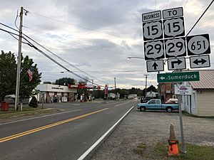
U.S. Route 15 and U.S. Route 29 are the main roads that lead to the Remington area. To get directly into downtown Remington, you can use U.S. Route 15 Business and U.S. Route 29 Business. Other local roads connect Remington to nearby parts of Fauquier County.
Notable People
- Jud "Boojum" Wilson - A famous baseball player.
See also
 In Spanish: Remington (Virginia) para niños
 | Stephanie Wilson |
 | Charles Bolden |
 | Ronald McNair |
 | Frederick D. Gregory |


