Retsof, New York facts for kids
Quick facts for kids
Retsof, New York
|
|
|---|---|
| Country | United States |
| State | New York |
| County | Livingston |
| Town | York |
| Area | |
| • Total | 0.45 sq mi (1.17 km2) |
| • Land | 0.45 sq mi (1.17 km2) |
| • Water | 0.00 sq mi (0.00 km2) |
| Elevation | 726 ft (221 m) |
| Population
(2020)
|
|
| • Total | 326 |
| • Density | 722.84/sq mi (279.35/km2) |
| Time zone | UTC-5 (Eastern (EST)) |
| • Summer (DST) | UTC-4 (EDT) |
| ZIP Code |
14539
|
| Area code(s) | 585 |
| GNIS feature ID | 962414 |
| FIPS code | 36-61236 |
Retsof is a small community in New York, United States. It's known as a hamlet, which is a small village. It is also a census-designated place (CDP), meaning it's an area the government counts for population data. Retsof is located in Livingston County, within the town of York.
This community is about 30 miles (48 km) southwest of the city of Rochester. You can find it off New York State Route 63. In 2020, about 326 people lived in Retsof.
Retsof was founded by a man named William Foster, Jr. He named the town by spelling his last name backwards! For a long time, Retsof was home to one of the world's largest salt mines. This mine was very important until it collapsed in 1994. A new salt mine, called the Hampton Corners mine, is now located nearby, about 10 miles (16 km) southeast of Retsof, near Mount Morris.
Many of the first people to live in Retsof were from Italy. They lived in a "company town," which means the salt mine company owned their houses and even a store. The company took care of the small village. Most of the Italian families lived together. A few people who were not Italian, mostly bosses, lived in nicer houses on "the Avenue" that had indoor plumbing.
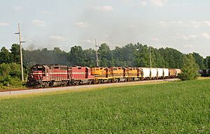
Besides the salt mine, there was a small railroad called the Genesee & Wyoming Railroad (G&W). This railroad helped move the salt to bigger train lines in nearby towns. Today, the G&W is still active. It works as a branch line for the Rochester & Southern Railroad.
Contents
Where is Retsof Located?
Retsof is in the northwestern part of Livingston County. It's in the southeastern section of the town of York. To the east of Retsof, you'll find the hamlet of Piffard. To the west is Greigsville.
New York State Route 63 goes southeast from Retsof for about 4 miles (6 km) to Geneseo. Geneseo is the main town for Livingston County. If you go northwest on Route 63, you'll reach Batavia, which is about 20 miles (32 km) away. The main hamlet of York is about 3 miles (5 km) north of Retsof.
The area of Retsof is about 0.45 square miles (1.17 square kilometers), and it's all land. A stream called Salt Creek flows through the community. This creek flows north and eventually joins Bidwells Creek, which then flows northeast into the Genesee River.
How Many People Live in Retsof?
| Historical population | |||
|---|---|---|---|
| Census | Pop. | %± | |
| 2020 | 326 | — | |
| U.S. Decennial Census | |||
According to the 2020 United States Census, the population of Retsof was 326 people.
The Retsof Salt Mine Story
In 1994, the Retsof Salt Mine was a huge place. It was the largest salt mine in North America and the second largest in the world! About 300 people worked deep underground, about 1,000 feet (300 meters) below the surface. They were digging out salt from a natural deposit. This salt was used for many things, like melting ice on roads, as table salt for food, and in different industries.
What Happened to the Mine?
In March 1994, something big happened. The ceiling in one of the large underground rooms collapsed. This was the start of a series of problems. Water from underground began to flow into the salt deposit. The mine had been dry for 110 years before this!
Over the next 21 months, more parts of the mine collapsed. The underground spaces filled up with water. Miners tried to work in the areas they could still reach before the water spread. But by 1995, the mine was completely filled with water, and all mining had to stop.
Effects of the Mine Collapse
When the mine filled with water, it caused other problems above ground. The water level in the ground, called the aquifer, dropped. This made many drinking water wells dry. Also, the ground above the mine started to sink. This sinking is called subsidence. Some areas even had large holes, called sinkholes, appear. Some of these sinkholes were 200 feet (60 meters) wide! This damaged buildings and highways. Experts believe the ground might sink another 8 or 9 feet (2.4 or 2.7 meters) over the next 100 years.
The U.S. Geological Survey is a science agency that studied how the mine collapse affected the underground water in the area.
See also
 In Spanish: Retsof (Nueva York) para niños
 | Frances Mary Albrier |
 | Whitney Young |
 | Muhammad Ali |


