
Mount Morris (village), New York facts for kids
Quick facts for kids
Mount Morris, New York
|
|
|---|---|

Mount Morris (village), New York
Location in New York

Mount Morris (village), New York
Location in the United States
|
|
| Country | United States |
| State | New York |
| County | Livingston |
| Town | Mount Morris |
| Area | |
| • Total | 2.05 sq mi (5.30 km2) |
| • Land | 2.05 sq mi (5.30 km2) |
| • Water | 0.00 sq mi (0.00 km2) |
| Elevation | 630 ft (192 m) |
| Population
(2020)
|
|
| • Total | 2,898 |
| • Density | 1,415.04/sq mi (546.45/km2) |
| Time zone | UTC-5 (Eastern (EST)) |
| • Summer (DST) | UTC-4 (EDT) |
| ZIP code |
14510
|
| Area code(s) | 585 |
| FIPS code | 36-48945 |
| GNIS feature ID | 0957862 |
Mount Morris is a small village located in Livingston County, New York, United States. It's part of the larger town of Mount Morris. In 2020, about 2,898 people lived in the village. Both the village and the town are named after Robert Morris, who was important in American history.
The village is right at the entrance to Letchworth State Park. This park is famous for its beautiful gorge and three amazing waterfalls on the Genesee River.
Contents
History of Mount Morris
The area was first called "Allen Hill" and "Richmond Hill" by an early settler named Ebenezer Allen. The village of Mount Morris officially became a village in 1835. It was named after Robert Morris, who helped fund the American Revolution. He later owned a large area of land called the Morris Reserve, and parts of it were sold to people who wanted to settle there.
In the early days, a very important way to transport goods was the Genesee Valley Canal. This canal went south from the Erie Canal in Rochester all the way to Olean. The canal was no longer used in the 1870s. Later, its path was used for railroad tracks. Today, groups like the Friends of the Genesee Valley Greenway have turned parts of the old canal route into hiking trails.
An important school called Mount Morris Academy was in the village, but it closed in 1867.
Just outside the village, on the Genesee River, is the Mount Morris Dam. This huge dam is about 550 feet (168 meters) long and 216 feet (66 meters) high. It was built between 1948 and 1952 to help control floods in the lower Genesee Valley. There's also an older, smaller dam in the village that used to power mills. Now, it's a small station that generates hydroelectric power.
In the early 2000s, a retired New York City detective and developer named Greg O'Connell bought many buildings on the village's Main Street. He did this to help bring new life and businesses to the downtown area.
Historic Places in Mount Morris
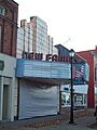
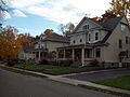
Many important buildings and areas in Mount Morris are listed on the National Register of Historic Places. This means they are recognized for their historical importance and are protected. Some of these include old houses, the New Family Theater, and historic street areas like Murray Street and South Main Street.
| Name on the Register | Image | Date listed | Location | City or town | Description | |
|---|---|---|---|---|---|---|
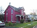
| 1 | House at No. 13 Grove Street |
 |
(#98001582) |
13 Grove St. 42°43′41″N 77°52′37″W / 42.728056°N 77.876944°W |
Mount Morris | |
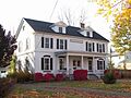
| 2 | House at No. 176 South Main Street |
 |
(#98001581) |
176 S. Main St. 42°43′08″N 77°52′16″W / 42.718889°N 77.871111°W |
Mount Morris | |
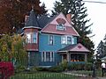
| 3 | House at No. 30 Murray Street |
 |
(#98001585) |
30 Murray St. 42°43′22″N 77°52′32″W / 42.722778°N 77.875556°W |
Mount Morris | |
| 4 | House at No. 48 Grove Street |
(#98001583) |
48 Grove St. 42°43′39″N 77°52′54″W / 42.7275°N 77.881667°W |
Mount Morris | ||
| 5 | House at No. 8 State Street |
 |
(#98001580) |
8 State St. 42°43′33″N 77°52′24″W / 42.725833°N 77.873333°W |
Mount Morris | |
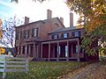
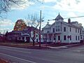
| 6 | Gen. William A. Mills House |
 |
(#78001858) |
14 Main St. 42°43′36″N 77°52′31″W / 42.726667°N 77.875278°W |
Mount Morris | |
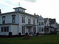
| 7 | Murray Street Historic District |
 |
(#96000178) |
33-47 and 32-46 Murray St. 42°43′18″N 77°54′05″W / 42.721667°N 77.901389°W |
Mount Morris | |
| 8 | New Family Theater |
 |
(#97000846) |
102 Main St. 42°43′27″N 77°52′26″W / 42.724167°N 77.873889°W |
Mount Morris | |
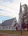
| 9 | St. John's Episcopal Church |
 |
(#91000892) |
Jct. of State and Stanley Sts. 42°43′28″N 77°52′36″W / 42.724444°N 77.876667°W |
Mount Morris | |
| 10 | South Main Street Historic District |
 |
(#96000177) |
123-159 and 124-158 S. Main St. 42°43′18″N 77°52′18″W / 42.721667°N 77.871667°W |
Mount Morris | |
| 11 | State and Eagle Streets Historic District |
 |
(#96000179) |
16-34 and 15-39 State St. and 6-12 Eagle St. 42°43′28″N 77°52′42″W / 42.724444°N 77.878333°W |
Mount Morris |
Famous People from Mount Morris
Mount Morris has been home to several notable individuals:
- Roscoe C. Barnes: A baseball player who hit the first recorded home run in professional baseball. He was also the first batting champion of the National League.
- Francis Bellamy: The person who wrote the United States Pledge of Allegiance.
- Mary Seymour Howell: A local woman who was a suffragette. This means she worked for women's right to vote. She was also a friend of Susan B. Anthony.
- John Wesley Powell: The first white man to explore and map the Colorado River.
- Joseph Strauss: An inventor and an admiral in the United States Navy.
Geography and Climate
Mount Morris is located in the western part of Livingston County. It covers an area of about 2.05 square miles (5.3 square kilometers), and all of it is land. The Genesee River forms the northern edge of the village. Two smaller streams, Allens Creek and Damonsville Creek, also flow through the village.
Major roads like New York State Route 36 and New York State Route 408 meet in the village. Geneseo, which is the main town for the county, is about 6 miles (10 km) northeast. Interstate 390 is about 2 miles (3 km) east of the village. This highway can take you north to Rochester (about 36 miles or 58 km away) or southeast to Corning (about 65 miles or 105 km away).
Climate in Mount Morris
Mount Morris gets less rain and snow than many other places in Upstate New York and the northeastern United States. It's actually known as one of the driest places in New York. On average, it receives about 27.7 inches (704 mm) of precipitation each year.
Transportation
Mount Morris is on the Rochester-to-Dansville railway line, which is operated by the Rochester & Southern Railroad. This line was once part of a major route that connected New York City to Buffalo.
Historically, Mount Morris was served by three other railroads:
- The Erie Railroad had a line that offered frequent electric railway service to Rochester from 1907 to 1934.
- The Dansville and Mount Morris Railroad connected its namesake towns.
- The Pennsylvania Railroad also had a line through Mount Morris.
Many of these older railroad lines were eventually abandoned. The path of the old Pennsylvania Railroad line now forms part of the Genesee Valley Greenway, which is used for hiking and other outdoor activities.
Today, Mount Morris is also where the Rochester & Southern Railroad connects to a branch line that goes to the Hampton Corners salt mine. This line was built in the 1990s, making it one of New York state's newer railway lines.
Population Information
| Historical population | |||
|---|---|---|---|
| Census | Pop. | %± | |
| 1870 | 1,930 | — | |
| 1880 | 1,899 | −1.6% | |
| 1890 | 2,286 | 20.4% | |
| 1900 | 2,410 | 5.4% | |
| 1910 | 2,782 | 15.4% | |
| 1920 | 3,312 | 19.1% | |
| 1930 | 3,238 | −2.2% | |
| 1940 | 3,530 | 9.0% | |
| 1950 | 3,450 | −2.3% | |
| 1960 | 3,250 | −5.8% | |
| 1970 | 3,417 | 5.1% | |
| 1980 | 3,039 | −11.1% | |
| 1990 | 3,102 | 2.1% | |
| 2000 | 3,266 | 5.3% | |
| 2010 | 2,986 | −8.6% | |
| 2020 | 2,898 | −2.9% | |
| U.S. Decennial Census | |||
In 2020, the village of Mount Morris had a population of 2,898 people. The population has changed over the years, as shown in the table above.
Images for kids
-
House at No. 13 Grove Street
-
House at No. 176 South Main Street
-
House at No. 30 Murray Street
-

House at No. 8 State Street
-
Gen. William A. Mills House
-
Murray Street Historic District
-
New Family Theater
-
St. John's Episcopal Church
-
South Main Street Historic District
-
State and Eagle Streets Historic District
See also
 In Spanish: Mount Morris (villa) para niños
