Reynolds Peak (Washington) facts for kids
Quick facts for kids Reynolds Peak |
|
|---|---|

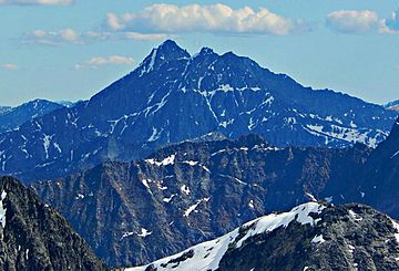
Reynolds Peak seen from Wallaby Peak
|
|
| Highest point | |
| Elevation | 8,517 ft (2,596 m) NAVD 88 |
| Prominence | 2,032 ft (619 m) |
| Isolation | 8.55 mi (13.76 km) |
| Geography | |
| Parent range | North Cascades |
| Topo map | USGS Sun Mountain |
| Climbing | |
| First ascent | 1898 or 1899 by Survey Party including Albert Hale Sylvester |
| Easiest route | Scrambling |
Reynolds Peak is a tall mountain in Washington state, standing at 8,517 feet (2,596 meters) high. It is part of the Methow Mountains, which are a smaller group of peaks within the larger North Cascades mountain range.
This impressive peak is located inside the Lake Chelan-Sawtooth Wilderness, a protected area within the Okanogan National Forest. This means the natural beauty and wildlife around Reynolds Peak are carefully preserved.
Reynolds Peak has a smaller peak nearby called North Peak. North Peak is about 0.3 miles (0.5 kilometers) north of the main summit and is 8,384 feet (2,555 meters) tall. The closest mountain that is even taller than Reynolds Peak is Oval Peak, which is about 8.55 miles (13.76 kilometers) to the southeast.
Water from rain and melting snow flows off Reynolds Peak in different directions. On the east side, the water drains into the Twisp River through a stream called Reynolds Creek. On the west side, the water flows into the Stehekin River through Boulder Creek.
Contents
What is the Weather Like at Reynolds Peak?
The area around Reynolds Peak is located east of the main Cascade Range mountains. This means it gets a bit less rain and snow compared to places on the western side.
Summer Weather at Reynolds Peak
During the summer, Reynolds Peak can experience warm temperatures. Sometimes, there are also thunderstorms, which bring exciting changes to the weather.
Winter Weather at Reynolds Peak
Because Reynolds Peak is so high, it can have snow on its slopes even in late spring and early fall. In the winter, the mountain becomes very cold, often covered in deep snow.
How Did Reynolds Peak Form?

The North Cascades mountains, where Reynolds Peak is located, have a very rugged and dramatic landscape. You can see sharp peaks, long ridges, and deep valleys carved by glaciers.
Geological Events that Shaped the Cascades
Many millions of years ago, huge geological events created this amazing scenery. These events caused big changes in elevation and led to different climates across the Cascade Range. These climate differences then created various types of plant life in different areas.
The History of Mountain Formation
The Cascade Mountains began forming millions of years ago, during a time called the late Eocene Epoch. This happened because the North American Plate (a huge piece of Earth's crust) was slowly moving over the Pacific Plate. This movement caused many volcanoes to erupt.
Also, small pieces of Earth's crust, called terranes, came together to form the North Cascades about 50 million years ago.
The Role of Glaciers in Shaping the Landscape
Over two million years ago, during the Pleistocene period, glaciers played a huge role. These massive sheets of ice moved across the land many times, carving out the landscape and leaving behind rocks and debris.
The "U"-shaped valleys you see in the rivers today were formed by these glaciers. The combination of the land being pushed upwards (called uplift) and cracks in the Earth's crust (called faulting), along with the action of glaciers, created the tall peaks and deep valleys of the North Cascades.
 | Jackie Robinson |
 | Jack Johnson |
 | Althea Gibson |
 | Arthur Ashe |
 | Muhammad Ali |


