Richmond, South Australia facts for kids
Quick facts for kids RichmondAdelaide, South Australia |
|||||||||||||||
|---|---|---|---|---|---|---|---|---|---|---|---|---|---|---|---|
| Postcode(s) | 5033 | ||||||||||||||
| Location | 3 km (2 mi) west of Adelaide | ||||||||||||||
| LGA(s) | City of West Torrens | ||||||||||||||
| State electorate(s) | Ashford | ||||||||||||||
| Federal Division(s) | Adelaide | ||||||||||||||
|
|||||||||||||||
Richmond is a suburb located close to the centre of Adelaide, South Australia. It sits on the traditional lands of the Kaurna people. Richmond is part of the City of West Torrens area.
Contents
A Look at Richmond's Past
Richmond started as farmland in the late 1830s. More homes and businesses began to appear in the late 1800s and early 1900s. The area grew even more between the two World Wars. Most of its growth happened after World War II. The number of people living here slowly increased between 2001 and 2006 as new houses were built.
The suburb got its name from the first farm built here in 1839. This farm belonged to Charles Gooch. In 1842, the land around it was divided up and called "The Village of Richmond."
A famous horse stud called "Richmond Park" used to be at the end of Richmond Road. It was owned by James Henry Aldridge. Today, this land is part of the Adelaide Airport.
Life in Richmond
In 2008, Richmond was named one of the best suburbs to live in among Adelaide's western areas. It's a great place for families and young people.
Fun Things to Do in Richmond
Shopping and Places to Eat
Even though Richmond is mostly a place where people live, you can find small shops and businesses. These are mainly located along Richmond Road and South Road.
Parks and Green Spaces
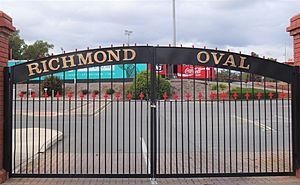
The most well-known green area in Richmond is Richmond Oval. You can find it on Milner Road. This large sports ground can hold 16,000 people! It has been the home ground for the West Adelaide Football Club since 1958.
The Westside Bikeway is a special path for cycling and walking. It runs next to Deacon Avenue. This path used to be a railway line called the Holdfast Bay railway line, which closed in 1929.
Richmond was also home to the Apollo Stadium. This was Adelaide's main indoor place for entertainment and sports. It opened in 1969 and was used until 1991. It was named after the Apollo Moon landing! After 1992, it became a church before closing for good in 1997.
Getting Around Richmond
Main Roads
Several important roads help people travel through Richmond:
 South Road: This road goes from the far north of Adelaide all the way to the far south.
 Marion Road: This road also runs north to south, connecting Torrensville and Sturt.
 Sir Donald Bradman Drive: This road goes from east to west, linking the City of Adelaide to West Beach.
Public Transport Options
Richmond is served by public transport run by Adelaide Metro. This includes buses and nearby trains.
Trains
There isn't a train station right in Richmond. However, the Belair, Seaford, and Tonsley train lines pass close by to the east. The closest train stations are Mile End and Adelaide Showground.
Trams
In the past, trams used to run through Richmond. However, these tram lines were removed in the 1950s and 1960s.
Buses
Many bus routes serve the Richmond area. Here are some of them:
- 100, 101
- Timetable
- Route map
- 135
- Timetable
- Route map
- 167, 168
- Timetable
- Route map
- 548
- Timetable
- Route map
- J7
- Timetable
- Route map
 | William Lucy |
 | Charles Hayes |
 | Cleveland Robinson |


