Rigside facts for kids
Quick facts for kids Rigside |
|
|---|---|
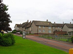
 Beechgrove Street, Rigside |
|
| Area | 0.24 km2 (0.093 sq mi) |
| Population | 620 (2020) |
| • Density | 2,583/km2 (6,690/sq mi) |
| OS grid reference | NS879351 |
| • Edinburgh | 34 mi (55 km) NE |
| • London | 320 mi (510 km) SE |
| Civil parish |
|
| Council area | |
| Lieutenancy area | |
| Country | Scotland |
| Sovereign state | United Kingdom |
| Post town | LANARK |
| Postcode district | ML11 |
| Dialling code | 01555 |
| Police | Strathclyde |
| Fire | Strathclyde |
| Ambulance | Scottish |
| EU Parliament | Scotland |
| UK Parliament |
|
| Scottish Parliament | |
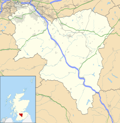
Rigside is a small village located in South Lanarkshire, Scotland. It's about 5 miles (8 kilometers) away from the town of Lanark. The village is also less than 1 mile (1.6 kilometers) from Douglas Water.
Rigside sits along the A70 road, which leads to Ayr. Around 800 people live in Rigside.
This village used to be a place where people worked in coal mines. Today, Rigside has a shop, a takeaway cafe, a pub, and a doctor's office. It doesn't have many public transport options, so most people use cars to get around.
Rigside has a nursery and a primary school for younger children. Both schools are on Muirfoot Road, right next to a modern play park and a skate park.
The houses in Rigside use different ways to stay warm. Many homes use air source heat pumps (ASHP), which take heat from the air outside. Other houses use coal, oil, or LPG for heating. The village does not have a main gas supply.
There are both privately owned houses and council-owned houses in Rigside. Many of the council-owned homes are being updated to use air source heat pumps instead of older heating systems.
Weather in Rigside
The weather in Rigside is measured at a nearby station called Drumalbin. This station is located about 245 meters (804 feet) above sea level.
| Climate data for Drumalbin, Elevation: 245 m (804 ft), 1991–2020 normals | |||||||||||||
|---|---|---|---|---|---|---|---|---|---|---|---|---|---|
| Month | Jan | Feb | Mar | Apr | May | Jun | Jul | Aug | Sep | Oct | Nov | Dec | Year |
| Mean daily maximum °C (°F) | 5.4 (41.7) |
5.9 (42.6) |
7.9 (46.2) |
10.8 (51.4) |
14.0 (57.2) |
16.3 (61.3) |
18.0 (64.4) |
17.7 (63.9) |
15.3 (59.5) |
11.6 (52.9) |
8.0 (46.4) |
5.7 (42.3) |
11.4 (52.5) |
| Daily mean °C (°F) | 2.9 (37.2) |
3.2 (37.8) |
4.7 (40.5) |
6.9 (44.4) |
9.7 (49.5) |
12.3 (54.1) |
14.0 (57.2) |
13.9 (57.0) |
11.8 (53.2) |
8.5 (47.3) |
5.4 (41.7) |
3.1 (37.6) |
8.1 (46.6) |
| Mean daily minimum °C (°F) | 0.5 (32.9) |
0.4 (32.7) |
1.5 (34.7) |
3.1 (37.6) |
5.4 (41.7) |
8.3 (46.9) |
10.1 (50.2) |
10.0 (50.0) |
8.3 (46.9) |
5.5 (41.9) |
2.7 (36.9) |
0.6 (33.1) |
4.7 (40.5) |
| Average precipitation mm (inches) | 93.9 (3.70) |
77.3 (3.04) |
65.6 (2.58) |
49.8 (1.96) |
53.7 (2.11) |
65.1 (2.56) |
79.0 (3.11) |
82.0 (3.23) |
68.5 (2.70) |
99.1 (3.90) |
95.3 (3.75) |
100.8 (3.97) |
930.2 (36.62) |
| Average precipitation days (≥ 1.0 mm) | 15.8 | 13.7 | 12.6 | 11.5 | 11.6 | 12.1 | 13.6 | 13.8 | 11.8 | 14.9 | 15.6 | 15.6 | 162.7 |
| Source: Met Office | |||||||||||||
More Information

- You can find more about Rigside for kids in Spanish here: Rigside para niños
 | Mary Eliza Mahoney |
 | Susie King Taylor |
 | Ida Gray |
 | Eliza Ann Grier |


