Rincón de Romos facts for kids
Quick facts for kids
Rincón de Romos
|
|
|---|---|
|
City
|
|

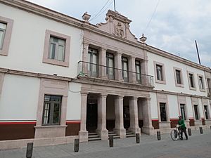
Municipal Palace
|
|

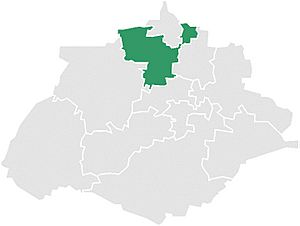
Municipality location in Aguascalientes
|
|
| Country | Mexico |
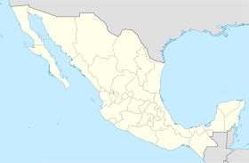
| State | Aguascalientes |
| Municipality | Rincón de Romos |
| Population
(2019)
|
|
| • Total | 94,978 |
Rincón de Romos is a city and a municipality in the state of Aguascalientes, Mexico. It's located in the northern part of the state. The city of Rincón de Romos is the main town for the surrounding municipality.
In 2019, the total population of the municipality was about 94,978 people. The city itself had a population of 27,988 in 2010.
Most people in Rincón de Romos are Catholic. They celebrate a special "Fiesta" for the Señor de las Angustias every January. This festival includes dances and fireworks. There is a church dedicated to him in the city center. Many locals work as teachers.
A long time ago, a priest named Padre Nieves lived here. People believed he could perform miracles. There is a church for him in the city, and many visitors come to Rincón de Romos to pray for miracles. The city also has the largest rural hospital run by the Aguascalientes government.
Contents
A Look at Rincón de Romos History
Rincón de Romos is in the central-northern part of Aguascalientes, Mexico. In 1639, a group called the Real Audiencia of Guadalajara allowed a small town to be created. This town was first known as Chora.
Later, in 1658, a captain named Diego Romo de Vivar y Pérez bought most of the land of Hacienda de Rincón. He bought it from Don Pedro Rincon of Arteaga. This deal combined both names, changing the town's name from Chora to Rincón de Romos.
Where is Rincón de Romos Located?
Rincón de Romos shares borders with several other municipalities. To the north, it borders Cosío. To the south, it borders Pabellón de Arteaga. On the east, it borders Tepezalá, and to the west, it borders San Jose de Gracia.
The municipality is divided into 64 smaller towns. The most important ones include the main city of Rincón de Romos, Pabellón de Hidalgo, Pablo Escaleras, San Jacinto, and El Bajio. The total area of Rincón de Romos is about 372.93 square kilometers. This makes up about 6.7% of the entire state's land.
Rincón de Romos is part of the Sierra Madre Occidental mountain range. There are also semi-flat areas in the center and northeast. Flat areas can be found between the Fria and Loreto mountains.
Climate and Weather
Rincón de Romos has a dry climate. The average temperature in the hottest months, May and August, is around 18 °C (64 °F). The area gets about 400 millimeters (15.7 inches) of rain each year. The wind usually blows from the north to the southeast during summer and part of autumn.
| Climate data for Rincón de Romos (1951–2010) | |||||||||||||
|---|---|---|---|---|---|---|---|---|---|---|---|---|---|
| Month | Jan | Feb | Mar | Apr | May | Jun | Jul | Aug | Sep | Oct | Nov | Dec | Year |
| Record high °C (°F) | 28.0 (82.4) |
32.0 (89.6) |
35.0 (95.0) |
37.0 (98.6) |
38.0 (100.4) |
38.0 (100.4) |
36.0 (96.8) |
34.0 (93.2) |
36.0 (96.8) |
32.0 (89.6) |
31.0 (87.8) |
28.0 (82.4) |
38.0 (100.4) |
| Mean daily maximum °C (°F) | 20.7 (69.3) |
22.8 (73.0) |
25.7 (78.3) |
28.6 (83.5) |
30.0 (86.0) |
29.2 (84.6) |
26.3 (79.3) |
26.0 (78.8) |
24.9 (76.8) |
24.5 (76.1) |
23.1 (73.6) |
21.2 (70.2) |
25.3 (77.5) |
| Daily mean °C (°F) | 11.5 (52.7) |
13.0 (55.4) |
15.6 (60.1) |
18.1 (64.6) |
20.0 (68.0) |
20.0 (68.0) |
18.5 (65.3) |
18.1 (64.6) |
17.3 (63.1) |
15.7 (60.3) |
13.5 (56.3) |
11.9 (53.4) |
16.1 (61.0) |
| Mean daily minimum °C (°F) | 2.2 (36.0) |
3.3 (37.9) |
5.5 (41.9) |
7.7 (45.9) |
9.9 (49.8) |
10.8 (51.4) |
10.7 (51.3) |
10.3 (50.5) |
9.7 (49.5) |
6.9 (44.4) |
4.0 (39.2) |
2.6 (36.7) |
7.0 (44.6) |
| Record low °C (°F) | −8.0 (17.6) |
−5.0 (23.0) |
−2.0 (28.4) |
0.0 (32.0) |
3.0 (37.4) |
4.0 (39.2) |
5.0 (41.0) |
5.0 (41.0) |
0.0 (32.0) |
−4.0 (24.8) |
−6.0 (21.2) |
−13.0 (8.6) |
−13.0 (8.6) |
| Average precipitation mm (inches) | 19.6 (0.77) |
10.5 (0.41) |
2.4 (0.09) |
6.4 (0.25) |
18.7 (0.74) |
53.0 (2.09) |
98.0 (3.86) |
78.5 (3.09) |
64.0 (2.52) |
34.6 (1.36) |
7.2 (0.28) |
10.1 (0.40) |
403.0 (15.87) |
| Average precipitation days (≥ 0.1 mm) | 2.2 | 1.4 | 0.6 | 1.1 | 3.5 | 6.8 | 10.5 | 9.4 | 8.0 | 3.5 | 1.1 | 1.9 | 50.0 |
| Source: Servicio Meteorologico Nacional | |||||||||||||
Population and Communities
| Historical population | ||
|---|---|---|
| Year | Pop. | ±% |
| 2010 | 49,156 | — |
| 2015 | 53,866 | +9.6% |
| 2020 | 57,369 | +6.5% |
In 2010, the entire municipality had a total population of 49,156 people. The city of Rincón de Romos itself had 27,988 residents.
Besides the main city, the municipality has 355 smaller communities. Some of the larger ones in 2010 included:
- Pabellón de Hidalgo (4,316 people)
- Escaleras (2,790 people)
- San Jacinto (2,356 people)
- El Bajío (1,278 people)
Local Economy
The Panamerican Highway is very important for trade in Rincón de Romos. There are also mines for mercury and copper, which are growing industries.
Farming and Crops
Farming is a big part of the economy, thanks to irrigation systems. Farmers grow many different crops, including:
Services for Residents and Visitors
Rincón de Romos offers many services. These include medical care, gas stations, and restaurants. There are also places for tourists to visit.
The city has a train station and a bus station for travel. You can find repair shops, taxis, and mail services. It also has its own university and high school for education.
See also
 In Spanish: Rincón de Romos para niños
 | Tommie Smith |
 | Simone Manuel |
 | Shani Davis |
 | Simone Biles |
 | Alice Coachman |


