Rio Grande water resource region facts for kids
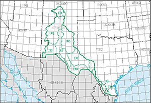
The Rio Grande water resource region is a huge natural area in the United States. It's one of 21 main regions that the United States Geological Survey (USGS) uses to study how water flows across the country. Think of these regions as giant natural bowls that collect water from rain and snow. Each region includes the area where a big river flows, or where several rivers flow together.
This special region is called "HUC 13" by scientists. It covers about 132,517 square miles (343,260 square kilometers), which is a really big space! Inside this large area, there are 9 smaller sections, called subregions. These subregions are numbered from 1301 to 1309.
The Rio Grande region includes all the land in the U.S. where water drains into the Rio Grande River. It also includes other unique areas like the San Luis Valley, North Plains, Plains of San Agustin, Mimbres River, Estancia, Jornada del Muerto, Tularosa Valley, and Salt Basin. Some of these are "closed basins," which means water flows into them but doesn't flow out to a river or ocean. This region stretches across parts of Colorado, New Mexico, and Texas.
Understanding Water Regions
Water resource regions help experts understand how water moves across the land. They are like giant puzzles where each piece is a natural area. Scientists use these regions to manage water, protect the environment, and plan for future water needs.
Why are Water Regions Important?
- Water Management: They help us understand where water comes from and where it goes. This is key for farming, drinking water, and keeping rivers healthy.
- Protecting Nature: By studying these regions, we can protect important places for plants and animals that depend on water.
- Planning for the Future: Knowing how much water is available helps communities plan for growth and prepare for dry times.
Exploring the Rio Grande Subregions
The Rio Grande region is divided into 9 subregions. Each one has its own unique features and plays a part in the larger water system. Let's take a closer look at these important areas.
| Subregion Code | Subregion Name | What's in This Subregion? | Where is it Located? | How Big is it? | Map |
|---|---|---|---|---|---|
| 1301 | Rio Grande Headwaters | This is where the Rio Grande River begins! It includes the river's starting points down to the Colorado-New Mexico border, plus the San Luis Valley. | Colorado and New Mexico. | 7,580 sq mi (19,600 km2) | |
| 1302 | Rio Grande–Elephant Butte | This section follows the Rio Grande from the Colorado-New Mexico border down to the Elephant Butte Reservoir. It also includes the North Plains, Jornada Del Muerto, and Plains of San Agustin areas. | Colorado and New Mexico. | 26,900 sq mi (70,000 km2) | |
| 1303 | Rio Grande–Mimbres | This part of the Rio Grande Basin goes from Elephant Butte Reservoir to where the borders of Mexico, New Mexico, and Texas meet. It also has the Jornada Draw, Mimbres River, and other closed basins west of the Rio Grande. | New Mexico and Texas. | 11,100 sq mi (29,000 km2) | |
| 1304 | Rio Grande–Amistad | This area covers the Rio Grande Basin from the Mexico-New Mexico-Texas border junction down to the Amistad Reservoir. It does not include the Pecos River Basin. | Texas | 18,700 sq mi (48,000 km2) | |
| 1305 | Rio Grande Closed Basins | This subregion includes several "closed basins" like Estancia, Tularosa Valley, and Salt Basin. These are areas where water collects but doesn't flow out to a river or ocean. They are located between the Rio Grande and Pecos River Basins. | New Mexico and Texas. | 17,500 sq mi (45,000 km2) | |
| 1306 | Upper Pecos | This section covers the Pecos River Basin, starting from its upper parts and going down to, but not including, the Delaware River Basin. | New Mexico and Texas. | 23,500 sq mi (61,000 km2) | |
| 1307 | Lower Pecos | This part of the Pecos River Basin starts from the Delaware River Basin and continues until the Pecos River joins the Rio Grande. | New Mexico and Texas. | 20,800 sq mi (54,000 km2) | |
| 1308 | Rio Grande–Falcon | This subregion follows the Rio Grande from Amistad Reservoir down to the Falcon Reservoir. | Texas | 5,170 sq mi (13,400 km2) | |
| 1309 | Lower Rio Grande | This is the final stretch of the Rio Grande Basin in the U.S., from Falcon Reservoir all the way to the Gulf of Mexico. | Texas. | 1,260 sq mi (3,300 km2) |
 | James Van Der Zee |
 | Alma Thomas |
 | Ellis Wilson |
 | Margaret Taylor-Burroughs |


