Rionegro facts for kids
Quick facts for kids
Rionegro
Santiago de Arma de Rionegro
|
|||
|---|---|---|---|
|
Municipality and city
|
|||
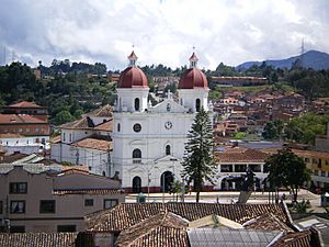
Catedral de San Nicolás el Magno
|
|||
|
|||
| Motto(s):
Cuna de la democracia (Cradle of Democracy)
|
|||
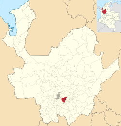
Location of the city (Marked in red) in the Antioquia region of Colombia
|
|||
| Country | |||
| Departamento | |||
| Subregion | Eastern | ||
| Founded | 1541 | ||
| Area | |||
| • Municipality and city | 195.9 km2 (75.6 sq mi) | ||
| • Urban | 9.5 km2 (3.7 sq mi) | ||
| Elevation | 2,125 m (6,972 ft) | ||
| Population
(2020 est.)
|
|||
| • Municipality and city | 142,995 | ||
| • Density | 729.94/km2 (1,890.5/sq mi) | ||
| • Urban | 90,256 | ||
| • Urban density | 9,500/km2 (24,610/sq mi) | ||
| Demonym(s) | Rionegrero | ||
| Area code(s) | 57 + 4 | ||
| Website | Official website: http://www.rionegro.gov.co/ | ||
Rionegro (pronounced rio-NEH-gro) is a city and municipality in the Antioquia Department of Colombia. It's located in the eastern part of Antioquia. The city's full official name is Ciudad Santiago de Arma de Rionegro.
The name "Rionegro" means "Black River" in Spanish. It got this name because a river that flows through the city often looks dark. This is due to the shadows cast by the many trees along its banks. This river is the most important natural feature of the area. Rionegro is also known as the Cuna de la democracia, which means "Cradle of Democracy." This nickname comes from its important role in Colombia's fight for independence. A key document, the 1863 constitution, was even written there.
Contents
History of Rionegro
Early Discoveries and Settlements
The area where Rionegro is located was first mentioned in 1541. This was by a Spanish officer named Álvaro de Mendoza. Later that year, another Spanish leader, Jorge Robledo, explored the area. He was the first European to discover the Valley of San Nicolás on September 2, 1541.
A Spanish nobleman, Don Juan Daza, later claimed these lands. On November 8, 1581, he officially marked the spot and began building a farm.
Growth and Independence
People from many parts of Colombia, including Santa Fe de Antioquia, moved to Rionegro. The small farm grew into a village and then a town in the early 1600s. A chapel dedicated to Saint Nicholas, now called Concatedral de San Nicolás el Magno, was built in 1642. This helped the area gain more independence for religious reasons.
For much of the 1700s, Rionegro was quite isolated by jungles and mountains. Its chapel was simple, made of straw and mud. By 1783, Rionegro had enough people to become a municipality. In 1786, it officially became the City of Santiago de Arma de Rionegro. This was approved by King Carlos III of Spain. After this, Rionegro became less isolated. A bishop visited in 1793 and ordered a new, stronger church to be built. This new church opened in 1803.
Rionegro became an important town, and new land was distributed. This led to the settlement of the southern part of the region. In the 1800s, Rionegro continued to grow. It was a key place during the end of Spanish rule and the start of Colombia's independence. For a time, it even competed with Santa Fe de Antioquia to be the capital of Antioquia. However, Medellín eventually grew much larger and became the main city.
Geography and Climate
Where is Rionegro Located?
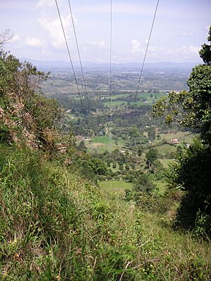
The municipality of Rionegro is in the central mountain range of the Andes. It is part of the eastern Antioquia sub-region. The city covers an area of about 196 square kilometers.
Rionegro is surrounded by several other municipalities:
- To the north: Guarne and San Vicente
- To the east: Marinilla and El Carmen de Viboral
- To the south: La Ceja
- To the west: El Retiro and Medellin
Mountains and Rivers
The city of Rionegro is located at an average height of 2,125 meters (about 6,972 feet) above sea level. The land is mostly made of volcanic ash and soil that resists erosion well.
The rest of the area ranges from 2,100 to 2,600 meters high. The landscape has many small hills. Some hills are taller and steeper, like Cerro del Capiro. This hill is on the border with La Ceja. A sharper mountain range is to the west. This range acts as a natural barrier between the Valley of Aburrá and the Plateau of Rionegro. The main streams that feed the Negro River start here. Important hills in this mountain chain include Alto Gordo and Cerro Corcovado.
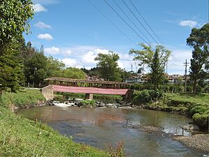
Part of the city is a flat area formed by the Negro River and its smaller rivers. These include the Pantanillo River and streams like Las Palmas. Historically, the Negro River divided the valley into two parts: Llanogrande Valley and San Nicholas Valley.
Hydroelectric Power
There are hydroelectric companies in the Rionegro area. They use the power of water to create electricity. One example is the Hydroelectric Power station at Guatapé, which uses the Santa Rita Dam. Today, the eastern Antioquia region has five power stations. Two of these are run by public companies from Medellín.
| Climate data for Rionegro (José María Córdova International Airport), elevation 2,073 m (6,801 ft), (1981–2010) | |||||||||||||
|---|---|---|---|---|---|---|---|---|---|---|---|---|---|
| Month | Jan | Feb | Mar | Apr | May | Jun | Jul | Aug | Sep | Oct | Nov | Dec | Year |
| Mean daily maximum °C (°F) | 21.8 (71.2) |
22.2 (72.0) |
22.3 (72.1) |
22.2 (72.0) |
22.5 (72.5) |
22.5 (72.5) |
22.5 (72.5) |
22.6 (72.7) |
22.4 (72.3) |
21.8 (71.2) |
21.6 (70.9) |
21.7 (71.1) |
22.2 (72.0) |
| Daily mean °C (°F) | 16.7 (62.1) |
17.1 (62.8) |
17.1 (62.8) |
17.3 (63.1) |
17.4 (63.3) |
17.3 (63.1) |
17.3 (63.1) |
17.3 (63.1) |
17.1 (62.8) |
16.5 (61.7) |
16.5 (61.7) |
16.6 (61.9) |
17.0 (62.6) |
| Mean daily minimum °C (°F) | 12.4 (54.3) |
12.6 (54.7) |
12.7 (54.9) |
13.2 (55.8) |
13.1 (55.6) |
12.4 (54.3) |
11.7 (53.1) |
11.9 (53.4) |
12.3 (54.1) |
12.5 (54.5) |
12.7 (54.9) |
12.6 (54.7) |
12.5 (54.5) |
| Average precipitation mm (inches) | 64.6 (2.54) |
81.4 (3.20) |
134.5 (5.30) |
206.7 (8.14) |
246.7 (9.71) |
178.0 (7.01) |
153.6 (6.05) |
167.7 (6.60) |
204.2 (8.04) |
231.5 (9.11) |
190.3 (7.49) |
104.2 (4.10) |
1,963.5 (77.30) |
| Average precipitation days (≥ 1.0 mm) | 15 | 15 | 19 | 23 | 24 | 21 | 20 | 20 | 24 | 25 | 22 | 17 | 241 |
| Average relative humidity (%) | 80 | 80 | 80 | 82 | 81 | 78 | 76 | 76 | 78 | 82 | 83 | 82 | 80 |
| Mean monthly sunshine hours | 164.3 | 144.0 | 136.4 | 126.0 | 155.0 | 180.0 | 217.0 | 217.0 | 174.0 | 145.7 | 132.0 | 139.5 | 1,930.9 |
| Mean daily sunshine hours | 5.3 | 5.1 | 4.4 | 4.2 | 5.0 | 6.0 | 7.0 | 7.0 | 5.8 | 4.7 | 4.4 | 4.5 | 5.3 |
| Source: Instituto de Hidrologia Meteorologia y Estudios Ambientales | |||||||||||||
| Climate data for Rionegro (Selva La), elevation 2,090 m (6,860 ft), (1981–2010) | |||||||||||||
|---|---|---|---|---|---|---|---|---|---|---|---|---|---|
| Month | Jan | Feb | Mar | Apr | May | Jun | Jul | Aug | Sep | Oct | Nov | Dec | Year |
| Mean daily maximum °C (°F) | 22.3 (72.1) |
22.5 (72.5) |
22.8 (73.0) |
22.6 (72.7) |
22.8 (73.0) |
22.8 (73.0) |
22.9 (73.2) |
23.1 (73.6) |
22.8 (73.0) |
22.4 (72.3) |
22.1 (71.8) |
22.1 (71.8) |
22.6 (72.7) |
| Daily mean °C (°F) | 16.6 (61.9) |
16.8 (62.2) |
17.0 (62.6) |
17.1 (62.8) |
17.1 (62.8) |
17.0 (62.6) |
16.8 (62.2) |
16.9 (62.4) |
16.8 (62.2) |
16.5 (61.7) |
16.6 (61.9) |
16.6 (61.9) |
16.8 (62.2) |
| Mean daily minimum °C (°F) | 12.0 (53.6) |
12.2 (54.0) |
12.5 (54.5) |
13.0 (55.4) |
12.9 (55.2) |
12.0 (53.6) |
11.3 (52.3) |
11.4 (52.5) |
12.0 (53.6) |
12.4 (54.3) |
12.6 (54.7) |
12.3 (54.1) |
12.2 (54.0) |
| Average precipitation mm (inches) | 64.1 (2.52) |
86.8 (3.42) |
131.7 (5.19) |
199.8 (7.87) |
247.6 (9.75) |
187.4 (7.38) |
169.4 (6.67) |
180.2 (7.09) |
212.3 (8.36) |
225.2 (8.87) |
183.8 (7.24) |
98.8 (3.89) |
1,987.1 (78.23) |
| Average precipitation days (≥ 1.0 mm) | 14 | 16 | 19 | 21 | 24 | 20 | 19 | 20 | 23 | 24 | 21 | 16 | 237 |
| Average relative humidity (%) | 80 | 80 | 80 | 81 | 81 | 79 | 78 | 78 | 79 | 81 | 81 | 81 | 80 |
| Mean monthly sunshine hours | 158.1 | 138.3 | 130.2 | 114.0 | 139.5 | 168.0 | 204.6 | 195.3 | 153.0 | 120.9 | 120.0 | 142.6 | 1,784.5 |
| Mean daily sunshine hours | 5.1 | 4.9 | 4.2 | 3.8 | 4.5 | 5.6 | 6.6 | 6.3 | 5.1 | 3.9 | 4.0 | 4.6 | 4.9 |
| Source: Instituto de Hidrologia Meteorologia y Estudios Ambientales | |||||||||||||
People and Population
How Many People Live in Rionegro?
In 2005, a census by the National Administrative Department of Statistics (DANE) counted 101,046 people living in Rionegro. This made it the sixth largest populated area in Antioquia. The city had about 466 people per square kilometer.
By 2020, the population of Rionegro was estimated to be 142,995 people.
Who Lives in Rionegro?
Most of the people in Rionegro are of mixed European and Indigenous (Mestizo) or European (White) backgrounds, making up 98.9% of the population. About 1.1% are of Afro Colombian heritage.
The population is split almost evenly between men (48.6%) and women (51.4%). A small number of people (5.7%) were unable to read or write, but most of these were very young children.
Public services in Rionegro are generally good. About 98.7% of homes have electricity, 95.6% have a water supply, and 87.1% have a telephone connection.
How Rionegro is Governed
The Mayor and Municipal Council
Rionegro is run by a democratic system. This means that citizens vote for their leaders. The system is based on Colombia's Political Constitution of 1991.
The city has a mayor who leads the local government. The mayor is in charge of managing the city's resources. This includes things like health, housing, education, and roads. The mayor also works to improve the quality of life for citizens. The mayor is chosen by popular vote for a four-year term.
There is also a Municipal Council in Rionegro. It has 17 politicians from different political parties. They are also elected for four years. The council's job is to approve the mayor's plans and projects. They also create the city's budget and manage collecting taxes.
Economy
What is Rionegro's Economy Like?
Rionegro has become the most important business center in eastern Antioquia. This is because of its good location. The city has grown a lot and is considered one of the wealthiest in Colombia.
Its economy is mainly based on different types of industries. These include food, fabric, paper, and chemical industries. Trade is also very important. These activities help give the people of Rionegro a high standard of living. Farming also plays a big role in the local economy. The main agricultural activities are growing flowers and raising poultry (like chickens).
Transportation
Getting Around Rionegro
Rionegro has private shuttle services that go to all parts of the city. There are also bus routes that connect Rionegro to Medellín and other nearby towns. Taxis are also commonly used within the city.
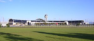
Rionegro is home to José María Córdova International Airport. This is the second most important airport in Colombia and serves Medellín. Both flights within Colombia and international flights arrive and depart from this airport.
Places to Visit
- Concatedral de San Nicolás el Magno - This cathedral was built in the 1790s and opened in 1804.
- Parque principal La Libertad (Main Liberty Park)
- Museo de Arte Religioso (Museum of Religious Art)
- Calle de la Madera (Wood Street)
- Tutucán
- Parque Los Osos Comfama de Rionegro (Comfama Bear Park of Rionegro)
- Casa de La Convención (House of the Convention)
- Puente Mejía (Mejía Bridge)
- Palacio de la Cultura Ricardo Rendón (Ricardo Rendón Culture Palace)
- Corregimiento San Antonio de Pereira (San Antonio de Pereira District)
- Casa de La Maestranza (House of the Maestranza)
- Parque de San Antonio de Pereira (San Antonio de Pereira Park)
- Iglesia de San Antonio de Pereira (Church of San Antonio de Pereira)
- Antiguo Colegio de Rionegro (Old School of Rionegro)
- Iglesia de San Francisco (Church of San Francisco)
- Iglesia de Jesus Nazareno (Church of Jesus Nazarene)
- Archivo Historico de Rionegro (Historical Archive of Rionegro)
- Estatua Ecuestre del General José María Cordova (Equestrian Statue of General José María Cordova)
- Cementerio Principal (Main Cemetery)
Religion
- Roman Catholic Diocese of Sonsón–Rionegro
Sports
Rionegro is home to the Categoría Primera A football (soccer) club Águilas Doradas. They have played their home games at the Estadio Alberto Grisales since March 2015.
Education
The Universidad Católica de Oriente is located in Rionegro. There is also a small branch of the University of Antioquia in the city.
Notable People
- Iván Córdoba, a famous Colombian former soccer player who played as a defender.
- Roberto Escobar, the older brother of Pablo Escobar.
See also
 In Spanish: Rionegro (Antioquia) para niños
 | James B. Knighten |
 | Azellia White |
 | Willa Brown |


