Ririe, Idaho facts for kids
Quick facts for kids
Ririe, Idaho
|
|
|---|---|

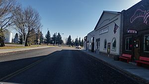
Smith st. and Main st., town park on the left
|
|

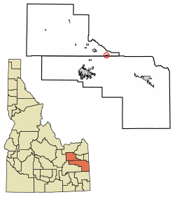
Location of Ririe in Bonneville County and Jefferson County, Idaho.
|
|
| Country | United States |
| State | Idaho |
| Counties | Jefferson, Bonneville |
| Area | |
| • Total | 0.53 sq mi (1.38 km2) |
| • Land | 0.52 sq mi (1.34 km2) |
| • Water | 0.01 sq mi (0.04 km2) |
| Elevation | 4,967 ft (1,514 m) |
| Population
(2010)
|
|
| • Total | 656 |
| • Density | 1,317.21/sq mi (508.22/km2) |
| Time zone | UTC-7 (Mountain (MST)) |
| • Summer (DST) | UTC-6 (MDT) |
| ZIP code |
83443
|
| Area code(s) | 208, 986 |
| FIPS code | 16-67960 |
| GNIS feature ID | 2410958 |
Ririe is a small city in eastern Idaho, located across parts of Bonneville and Jefferson counties. It is part of the Idaho Falls metropolitan area. In 2010, the city had a population of 656 people.
Contents
The Story of Ririe
Ririe is named after David Ririe, one of the first people to settle there. He arrived in the area in 1888 and started farming. In 1891, Joseph Hyrum Lovell and his family also settled nearby.
When Joseph Lovell passed away, David Ririe helped his family. He later married Joseph's daughter, Leah Ann. The families grew, and David built a large stone house that still stands today.
How Ririe Became a City
As more people moved to the area, they needed schools and churches. This helped create a community. The city of Ririe was officially started in 1914. This was when the railroad came through, and railroad officials gave the town its name.
A smaller community called Shelton was absorbed by Ririe. However, some places, like the Ririe-Shelton Cemetery, still use the Shelton name.
Changes Over Time
In the summer of 1919, a big fire destroyed much of the southern part of the town. But Ririe rebuilt! Since then, new buildings have been added. These include a school complex, an athletic field, and a church building.
Since 2007, nearly a thousand acres of land have been added to the town. This was done to prepare for new buildings and growth in the future.
Ririe's Location and Size
According to the United States Census Bureau, Ririe covers about 0.50 square miles (1.3 square kilometers). Most of this area is land, with a very small part being water.
Life and Culture in Ririe
Ririe and the areas around it mostly depend on farming. Farmers in the region grow crops like wheat, barley, alfalfa, and potatoes. Many people in Ririe either farm their own land or work in jobs that support farming. This includes supplying farm equipment or helping farmers sell their crops.
Work and Jobs
Besides farming, many residents work at the Idaho National Laboratory. This is a special center for the United States Department of Energy. They focus on nuclear energy and security technology. Other people work in different jobs in nearby towns.
Ririe's Place in the Region
Ririe is one of only three cities in Idaho that sits on two different county lines. It is close to three larger cities: Idaho Falls, Rexburg, and Rigby. Idaho Falls and Rexburg are about a half-hour drive away, and Rigby is about 15 minutes away. These nearby cities offer Ririe residents easy access to shopping, restaurants, and entertainment.
Local Businesses and Services
Because it is a small town and close to bigger cities, Ririe is often called a "bedroom" community. This means many people live there but travel to other towns for shopping and work. Ririe has only a few small businesses that have been successful. These include:
- Three gas stations
- Three restaurants
- Two convenience stores
- A bank
- An auto parts store
- An auto repair shop
- A metal design and fabrication shop
- One bar
The city also has a post office, a senior citizen center, a community library, a city park, and a community cemetery.
Schools and Safety
Ririe has its own public school system. This includes the Ririe Elementary School and Ririe High School. The city also has a community fire station. This station provides volunteer emergency medical services (EMS) and fire-fighting help to the area.
Community and Beliefs
The main religion in Ririe is The Church of Jesus Christ of Latter-day Saints. Many people in the city are members, and two large church buildings are used for many community activities. There is also a small non-denominational church in the community.
Outdoor Fun
Ririe is located in the Rocky Mountains and near the south fork of the Snake River. This means there are many outdoor activities to enjoy, such as:
- Snowmobiling
- Hiking
- Skiing
- Snowboarding
- Hunting
- Boating
- Camping
- Fishing
Heise Hot Springs is a local recreation area. It has places for golfing, camping, and swimming all year round. The Kelly Canyon Ski Area is a small ski resort with four chairlifts. It offers skiing during the day and at night in the winter.
Ririe's Population
| Historical population | |||
|---|---|---|---|
| Census | Pop. | %± | |
| 1920 | 396 | — | |
| 1930 | 422 | 6.6% | |
| 1940 | 493 | 16.8% | |
| 1950 | 527 | 6.9% | |
| 1960 | 560 | 6.3% | |
| 1970 | 575 | 2.7% | |
| 1980 | 555 | −3.5% | |
| 1990 | 596 | 7.4% | |
| 2000 | 545 | −8.6% | |
| 2010 | 656 | 20.4% | |
| 2019 (est.) | 681 | 3.8% | |
| U.S. Decennial Census | |||
In 2010, the city of Ririe had 656 people living there. There were 239 households and 166 families. The average household had about 2.74 people.
Who Lives in Ririe?
About 86.3% of the people in Ririe were White. About 1.1% were Native American, and 6.4% were from other races. About 13.7% of the population was Hispanic or Latino.
The average age in Ririe was 30.5 years old. About 33.4% of residents were under 18. About 11% were 65 years or older. The population was almost evenly split between males (48.6%) and females (51.4%).
See also
 In Spanish: Ririe para niños

