River Nar facts for kids
Quick facts for kids River Nar |
|
|---|---|

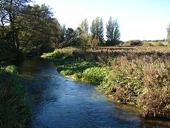
The River Nar at Castle Acre
|
|
| Country | England |
| Counties | Norfolk |
| Physical characteristics | |
| Main source | Tittleshall 70 m (230 ft) 52°44′57″N 0°48′43″E / 52.7491°N 0.8120°E |
| River mouth | River Great Ouse Kings Lynn 0 m (0 ft) 52°44′52″N 0°23′40″E / 52.7478°N 0.3944°E |
| Length | 15 mi (24 km) |
| Basin features | |
| River system | River Great Ouse |
| Site of Special Scientific Interest | |
| Area of Search | Norfolk |
|---|---|
| Interest | Biological |
| Area | 212.4 hectares (525 acres) |
| Notification | 1992 |
| Location map | Magic Map |
The River Nar is a river in England. It is a smaller river that flows into the much larger River Great Ouse. The Nar starts near Litcham in Norfolk and flows west for about 15 miles (24 km). It passes through towns like Castle Acre and Narborough, which is where the river gets its name. Finally, it joins the Great Ouse at King's Lynn.
In the past, the River Nar had other names, such as the Setch or the Lynn Flu, but these names are not used anymore. In 2011, the Environment Agency recognized the River Nar as one of the top ten most improved rivers in England and Wales. This means it has become much healthier for wildlife and people.
Long ago, part of the river near its end was moved. This happened when the Great Ouse was also rerouted in the 1200s. The Nar was made suitable for boats from its mouth up to Narborough, and possibly even to West Acre. This was done after a special law was passed in 1751. Boats used to carry goods along the river. However, when a railway line opened in the 1840s, fewer boats used the river. In 1884, the river was officially closed to boats.
Over many years, the river's power was used to run several mills. These mills ground things like corn or bones. Today, you can still see the buildings or remains of five of these old mills. Some even have their original machinery inside!
The entire river, which is about 26 miles (42 km) long, is a special protected area. It is called a Site of Special Scientific Interest because of its important plants and animals.
Contents
Discover the River Nar's Journey
The River Nar begins from natural springs. These springs are found on chalk hills near Tittleshall, about 200 feet (60 meters) above sea level. At first, the river flows east, then south. It goes under the B1145 Litcham Road near Mileham.
Flowing Through Villages and Estates
The river then turns west. It flows through the southern part of Litcham. After that, it enters a series of beautiful lakes at Lexham Hall. Here, another stream called Broad Water joins it. Lexham Hall is a very old and important mansion built around 1700. During World War II, the army used the estate, and it was damaged. It was later restored and its gardens are sometimes open to visitors.
Continuing west, the river reaches more lakes at West Lexham Hall. Another stream from Little Dunham flows into the Nar. The river then goes under the A1065 road and through Emanuel's Common. You can see the old Newton water mill before the river reaches Newton village. By the time it gets to Castle Acre, the river is below 100 feet (30 meters) in elevation.
Winding Through the Landscape
The river becomes wider and starts to curve more, forming "meanders." It passes more lakes at South Acre Hall, which is an old farmhouse from the 1500s. Then, it crosses Castle Acre Common. There are also several lakes in Big Wood. An old mill used to be at the end of this wood. The river and its mill bypass both cross a small road at places called fords.
At West Acre, the river flows past the ruins of an old Augustinian priory. It then passes Narford Lake, near Narford Hall. The priory ruins are protected as an ancient monument. Narford Hall is a grand building constructed between 1690 and 1704.
The river goes north of Narborough. Here, you'll find more lakes and a fish farm. The A47 road bypass crosses the river, as does the old main road to Narborough. Next to the old road is a former water mill. This mill was built in the 1700s and still has much of its machinery. The old railway line from Lynn to Dereham used to cross here, but it's now gone.
The Nar Valley Way and Final Stretch
The Nar Valley Way is a long walking path that follows the river for most of its journey. It runs along the river bank. As the river continues, you'll see many drainage ditches. After passing Abbey Farm, where there are more ruins of an Augustinian Priory, the river becomes "embanked." This means it has raised flood banks on both sides to control water. The Nar Valley Way crosses from one side of the river to the other here.
Further along, there are large lakes north of the river. These used to be a sand and gravel pit. High Bridge carries a road over the river, and Setchey Bridge carries the A10 road. A little further west, the river turns north. It is crossed by the railway line that goes to King's Lynn. The A47 road, the A148 road, and another small road cross the river at South Lynn. Finally, the River Nar joins the River Great Ouse at a sluice, which is a gate that controls water flow.
How Healthy is the River Nar?
The Environment Agency checks the water quality of rivers in England. They give each river an "ecological status" (how healthy the environment is) and a "chemical status" (how clean the water is from chemicals). The ecological status can be high, good, moderate, poor, or bad. The chemical status is either good or fail.
The River Nar is special because it's one of only a few "chalk streams" left. Chalk streams are rivers that get their water from underground chalk. This water is very clear, cool, and clean. It's like natural filter! This is why the whole River Nar is a Site of Special Scientific Interest.
In 2011, the Nar was named one of the top ten most improved rivers in England and Wales. This is great news! In the past, people made the river straighter and deeper for boats and to drain land. This damaged the natural homes for animals. Now, efforts are being made to fix this. For example, flood banks have been moved back, and new curves (meanders) have been created. Obstacles like weirs, which block fish, have also been removed.
Farmers are also helping to keep the river clean. A program called Catchment Sensitive Farming helps them reduce how much fertilizer and pesticides run into the water.
Amazing Wildlife of the River Nar
The River Nar is home to many different animals and plants.
- Fish: You might find sea trout, which are quite rare in this part of England.
- Mammals: Water voles and otters live along the banks.
- Plants: Over 78 different types of river plants have been found. This includes the beautiful southern marsh orchid.
- Insects: There are 12 different kinds of dragonflys flying around.
- Birds: Look out for grey wagtails, kingfishers, reed warblers, and willow and marsh tits.
A Look at the River's Past
Most of the River Nar flows along its original path. However, the part near its mouth has changed. It used to flow further west and join another river, the Gaywood River. But in the 1200s, the waters of the River Great Ouse were moved to King's Lynn. The Nar was also rerouted to join this new channel.
In 1751, people wanted to make the river better for boats. A special law was passed to allow this work. The goal was to make the river navigable all the way to West Acre. People called "Commissioners" were put in charge. They could build locks (water elevators for boats) and clear the river. They also set up tolls, which were fees for using the river.
Work began in 1757. The plan was to make the river suitable for boats carrying 10 tonnes of goods. Locks would be big enough for one boat at a time. The work was supposed to cost about £2,500. It was a big project, and it took longer than planned.
How the River Was Used
The main goods carried on the river were coal, corn, malt (used for brewing), and timber. In 1815, another law was passed to make the Nar deeper, wider, and straighter. This was to help with drainage and improve the land nearby.
The River's Decline and Changes
By the mid-1800s, a family called the Marriotts controlled the river's navigation. They tried to stop a new railway line from being built from King's Lynn to Dereham. But they weren't successful. The railway opened in 1846, and river trade quickly went down. In 1884, the river was officially closed to boats. This happened when a new sluice (water gate) was built near King's Lynn, blocking boats from entering the river.
The very last part of the river, called Friars Fleet, was used by small boats until 1932. These boats delivered gas water to a factory. Later, the river was moved again to a new sluice closer to the Great Ouse. In 2001, a special flood diversion channel was built. This channel helps move extra water from the Nar into the Ouse Flood Relief Channel during floods.
River Nar's Drainage System
Most of the River Nar is considered a "main river," which means the Environment Agency is responsible for it. Below Narborough, the river flows between raised flood banks. This means the water level in the river can be higher than the land next to it! So, water from the surrounding land can't just flow into the river by gravity.
To prevent flooding, a special group called the East of Ouse, Polver and Nar Internal Drainage Board (IDB) manages the area. They maintain drainage channels and pumping stations. These pumps lift water from the low-lying land into the main rivers. Their area includes most of the Nar Valley, and about 87% of it is farmland. The IDB has seven pumping stations to move water out of the area.
One important project involved rerouting a drain called the Puny Drain. It used to flow to an old outlet in King's Lynn. Now, it goes to a new outlet further upstream. This required building new channels and even putting pipes (syphons) under the railway line and the River Nar itself! These syphons are like giant U-shaped pipes that carry water underneath obstacles. This big project cost £5.5 million and took 18 months to complete. It was done carefully to protect wildlife like badgers and water voles.
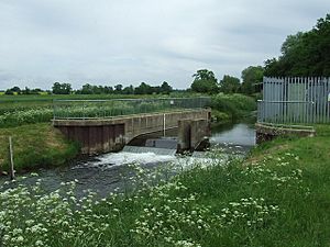
Another project in 2001 created a flood diversion channel. This channel helps send extra water into the Ouse Flood Relief Channel during heavy rains. It also included raising flood banks and creating a flood storage area. In 2011, a flood relief basin was also created. This basin can fill with water during storms when the Ouse River is too high to take water from the Nar. It then drains back into the river when the tide goes down.
Historic Mills Along the Nar
For many centuries, the River Nar provided power for several mills. Let's look at some of them, moving downstream from the river's source:
Newton Water Mill
The first mill was at Newton by Castle Acre. It was even mentioned in the Domesday Book, a famous survey from 1086! The current mill building is made of brick. It used to have a mill house attached, built with stone from a ruined priory. In the 1930s, the mill was used to grind corn. By the 1970s, the mill house was just a ruin, but a new one was built in the 1990s. Most of the mill's machinery, including the water wheel, was still there in 2003, though it wasn't working.
West Acre Mill
West Acre mill was a four-story building. Its ground floor was made of brick and dated back to the 1400s. It might have been built with materials from West Acre Abbey. The water wheel here powered four sets of grinding stones. In the 1950s, the machinery was considered amazing. However, the mill was torn down in 1959 because it was unsafe. Only the mill house remains today.
Narborough Mill
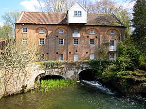
Narborough Mill was a large, three-story building constructed in 1780. An extension was added in 1845, but it wasn't built on strong enough foundations. The extension slowly sank until its roof collapsed in 1980. After the collapse, special piles were used to make the rest of the building stable before it was restored. A 14-foot (4-meter) water wheel powered six sets of millstones. The mill stopped working in the early 1950s, but most of its machinery is still inside.
Narborough Bone Mill
Further downstream was Narborough Bone Mill. This mill was unique because it had no road access! Bones were delivered by boat, and the ground bone meal was also taken away by boat. It was built in the early 1800s. It ground bones from local slaughterhouses, whalebones from the whaling industry in King's Lynn, and even bones from cemeteries in Hamburg. The mill stopped working around 1884 when the river was closed to boats. Even so, its large wheel is still a noticeable sight on the river bank.
Pentney Mill
The last mill was at Pentney. It was originally owned by a nearby priory. After the priory closed, the village moved closer to Narborough, leaving the mill isolated. It stopped being used in the 1800s. The remains show it was built of white brick. Later, it was even used as a pub!
Water Quality of the River Nar
The Environment Agency checks the water quality of river systems in England. They give each river an overall ecological status, which can be high, good, moderate, poor, or bad. This status looks at things like the number and types of invertebrates (bugs), plants, and fish. They also check the chemical status, which is either good or fail, by comparing chemical levels to safe limits.
Here's how the River Nar system's water quality was in 2016:
| Section | Ecological Status | Chemical Status | Overall Status | Length | Catchment | Channel |
|---|---|---|---|---|---|---|
| Nar upstream of Abbey Farm | Good | Good | Good | 18.4 miles (29.6 km) | 59.58 square miles (154.3 km2) | |
| Middleton Stop Drain | Moderate | Fail | Moderate | 6.9 miles (11.1 km) | 13.63 square miles (35.3 km2) | heavily modified |
| Nar downstream of Abbey Farm | Moderate | Good | Moderate | 9.5 miles (15.3 km) | 5.19 square miles (13.4 km2) | heavily modified |
The reasons why some parts of the river are not "good" quality include physical changes made to the river channels. For the Middleton Stop Drain, naturally occurring nickel also affects the water quality.
|
| Point | Coordinates (Links to map resources) |
OS Grid Ref | Notes |
|---|---|---|---|
| Modern entrance sluice | 52°44′51″N 0°23′45″E / 52.7475°N 0.3957°E | TF618193 | |
| 1884 tidal sluice | 52°44′18″N 0°23′59″E / 52.7384°N 0.3998°E | TF621183 | |
| Setchey Bridge | 52°41′39″N 0°25′11″E / 52.6941°N 0.4196°E | TF636134 | |
| Former junction with Little River | 52°41′36″N 0°26′11″E / 52.6933°N 0.4363°E | TF647134 | |
| High Bridge | 52°41′37″N 0°28′09″E / 52.6937°N 0.4693°E | TF669135 | Floodgate just upstream |
| Floodgate and sluice | 52°41′31″N 0°28′42″E / 52.6920°N 0.4783°E | TF675133 | |
| Sluice | 52°41′01″N 0°29′46″E / 52.6837°N 0.4962°E | TF688124 | |
| Sluice | 52°40′49″N 0°30′34″E / 52.6802°N 0.5094°E | TF697121 | Pentney Mill just upstream |
| Sluice | 52°40′40″N 0°32′04″E / 52.6779°N 0.5345°E | TF714119 | |
| Marham gauging station | 52°40′41″N 0°32′52″E / 52.6781°N 0.5479°E | TF723119 | |
| Sluice | 52°40′49″N 0°33′09″E / 52.6803°N 0.5525°E | TF726122 | |
| Narborough Bone Mill | 52°40′59″N 0°33′39″E / 52.6830°N 0.5608°E | TF731125 | ? sluice just downstream |
| Sluice | 52°41′16″N 0°34′24″E / 52.6879°N 0.5733°E | TF740131 | |
| Sluice below Narborough Wharf | 52°41′19″N 0°34′48″E / 52.6885°N 0.5800°E | TF744132 | |
| A47 Bridge (pen sluice below) | 52°41′34″N 0°35′19″E / 52.6929°N 0.5886°E | TF750137 | |
| West Acre bridge | 52°42′05″N 0°37′55″E / 52.7013°N 0.6319°E | TF779147 | River wider |
| Castle Acre bridge | 52°42′02″N 0°41′27″E / 52.7006°N 0.6909°E | TF819148 | |
| Lexham Hall and Broad Water | 52°43′03″N 0°45′51″E / 52.7174°N 0.7642°E | TF867168 | |
| Source near Tittleshall | 52°45′01″N 0°47′29″E / 52.7502°N 0.7913°E | TF884206 |
 | Sharif Bey |
 | Hale Woodruff |
 | Richmond Barthé |
 | Purvis Young |


