River Perry facts for kids
Quick facts for kids River Perry |
|
|---|---|

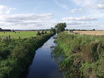
The river crossing Baggy Moor
|
|
| Country | England |
| Counties | Shropshire |
| Physical characteristics | |
| Main source | Springs near Gobowen 260 m (850 ft) |
| River mouth | River Severn, near Shrewsbury 55 m (180 ft) 52°44′40″N 2°49′51″W / 52.7445°N 2.8308°W |
| Length | 39 km (24 mi) |
The River Perry is a river in Shropshire, England. It starts near Oswestry and flows south. It joins the River Severn near Shrewsbury. The river is about 39 km (24 mi) long. Its water level drops by about 95 metres (312 ft) along its path.
People have changed the river a lot over time. They did this to power water mills. They also wanted to drain the land around it better. In the 1880s, there were at least seven corn mills. The last one stopped working in 1966. A big part of the river flows through Baggy Moor. This area was improved in 1777 to drain the wet land. This project was one of the biggest in North Shropshire. The land became very good for farming because of it. In the 1980s, a part of the river bed was made deeper.
The Llangollen Canal crosses the River Perry. Many bridges over the river are historic buildings. In the past, the river had pollution problems. This came from sewage and factories. Now, these are better controlled. But in 1985, a lot of farm waste spilled into the river. This caused about 100,000 fish to die.
Contents
Where Does the River Perry Flow?
The River Perry starts from springs near Hengoed. This is west of Gobowen and north of Oswestry. It begins at about 150 metres (490 ft) above sea level. The river flows under the railway line and the A5 road. It then goes around the north side of Gobowen. Other small streams join it here. Some of these streams start even higher up. One stream flows under the Llangollen Canal.
Journey Through Parks and Under Canals
The river then goes under the A495 road near Whittington. It flows into the park of Halston Hall. Here, it fills a large, pretty lake. Halston Hall is an old country house. It was built in the 1690s. It is a very important historic building. The river leaves the park and turns east. It is then crossed by the Montgomery Canal. The canal goes over the river on an aqueduct. This aqueduct had a big break in 1936. This made the canal close until 1987.
Flowing Through Moors and Past Historic Bridges
Next, the river turns south. It flows through Baggy Moor. Many drainage ditches join it here. The railway line crosses the river again. Then it reaches Ruyton-XI-Towns. Here, the river makes a big loop. Platt Mill Bridge crosses the river here. It was built in 1791. This bridge has two arches and is also a historic building. A round toll-house was built nearby. It is now a house.
Further south, Milford Bridge crosses the river. It has two arches and was built in 1831. The river then passes by Yeaton Peverey parkland. It reaches Forton Heath. Here, another bridge with one arch crosses it. Below this bridge, the River Perry joins the River Severn. This is close to Shrewsbury.
How the River Perry Works
The river starts on the edge of a sandstone plain. But for most of its path, it flows over Bunter Sandstone. Many streams come together east of Gobowen. These streams start from high up, about 260 metres (850 ft) above sea level. At first, the streams have stony bottoms. But soon, they flow over clay and silty soil.
Near Rednal, the Tetchill Brook adds more water. This brook starts from a large lake called Ellesmere. The Tetchill Brook was made to control the lake's water levels. The Newnes Brook also joins the Perry. This brook drains sandy soils between Ellesmere and Gobowen.
Draining Baggy Moor
After these brooks join, the river crosses Baggy Moor. This area used to be a big peat bog. It was often flooded in winter. But in 1777, a special law was passed. This allowed people to drain and improve a large area of land. This was a very big project for North Shropshire. Even though it was expensive, the land became very good for farming. Between 1985 and 1988, the river bed was lowered. This helped drain Baggy Moor even better.
River Bed and Flow
Below Ruyton, the river flows over boulder clay. It becomes stony again. The lower part of the river still has natural features. These include curves and shallow, fast-flowing areas. These spots are good homes for fish. But much of the upper river has been changed. It was made straighter to help the water flow faster.
River Perry's Water Quality
The Environment Agency checks the water quality of rivers in England. They give each river an overall "ecological status." This can be high, good, moderate, poor, or bad. They look at things like the types of invertebrates (like insects), plants, and fish. They also check the chemical status. This compares chemicals in the water to safe levels. Chemical status is either good or fail.
Here is how the River Perry and its smaller streams were rated in 2015:
| Section | Ecological Status | Chemical Status | Overall Status |
|---|---|---|---|
| Perry - from start to Common Brook | Moderate | Good | Moderate |
| Common Brook - from start to River Perry | Poor | Good | Poor |
| Perry - from Common Brook to Tetchill Brook | Moderate | Good | Moderate |
| Tetchill Brook - from start to River Perry | Poor | Good | Poor |
| War Brook - from start to River Perry | Poor | Good | Poor |
| Perry - from Tetchill Brook to River Severn | Moderate | Good | Moderate |
The water quality of the Common Brook has gotten better. It went from "bad" in 2009 to "poor" in 2015. The middle part of the Perry also improved from "poor" to "moderate." However, the War Brook got worse, going from "good" to "poor."
Pollution and River Health
Water quality is affected by water coming from sewage treatment plants. One plant sends water to the river from Oswestry. Another used to send water into the Tetchill Brook near Ellesmere. That sewage plant is now closed. Also, improvements have been made to other sewage pipes. The brook has been cleaned to remove dirty mud. Studies show the brook's quality is getting better. This is seen by the different kinds of small creatures living in it.
Factories that process dairy products also affect water quality. These and the sewage plants are usually well-controlled. But sometimes, farming practices cause serious pollution. The worst event was in September 1985. A large amount of pig waste spilled into the river. This caused all the fish to die, all the way down to the River Severn. About 100,000 fish died because of this pollution.
Water Mills on the River Perry
The River Perry has been changed a lot to power water mills. These mills used the river's flow to grind corn. The mill furthest upstream was likely Rednal Mill. Maps from the 1880s show seven other corn mills between Ruyton and the River Severn.
Famous Mills Along the River
New Mills was just below Platt Bridge. Milford Mill was just above Milford Bridge. Adcote Mill was near Adcote Farm. You can still see many of the old water channels there. There were two mills at Yeaton: Upper Mill and Lower Mill. These were on either side of Yeaton Bridge.
The last two mills were Fitz Mill and Mytton Mill. Fitz Mill worked from the 1100s until 1926. Its building is now used by a trucking company. Mytton Mill worked until 1966. After that, the building was empty for a few years. In 1971, it became offices for a builder. A fire badly damaged it in 1982. But the building was fixed. Now, it has workshops for small businesses.
Points of Interest Along the River Perry
| Point | Coordinates (Links to map resources) |
OS Grid Ref | Notes |
|---|---|---|---|
| Spring near Hengoed | 52°53′38″N 3°03′36″W / 52.8939°N 3.0599°W | SJ287334 | One of several sources |
| Spring near Pant-glas | 52°53′03″N 3°05′39″W / 52.8842°N 3.0941°W | SJ264324 | One of several sources |
| Halston Hall lake | 52°52′35″N 2°59′05″W / 52.8764°N 2.9848°W | SJ338314 | |
| Montgomery Canal crosses on aqueduct | 52°51′41″N 2°57′08″W / 52.8614°N 2.9522°W | SJ359297 | |
| Railway bridge | 52°49′15″N 2°53′38″W / 52.8209°N 2.8939°W | SJ398251 | |
| Site of New Mills Mill | 52°47′16″N 2°53′02″W / 52.7877°N 2.8839°W | SJ404214 | |
| Milford Mill | 52°47′04″N 2°51′45″W / 52.7844°N 2.8625°W | SJ419211 | |
| Adcote Mill | 52°46′15″N 2°51′25″W / 52.7707°N 2.8570°W | SJ422195 | |
| Yeaton Upper Mill | 52°46′03″N 2°50′43″W / 52.7676°N 2.8452°W | SJ430192 | |
| Fitz Mill | 52°45′27″N 2°49′31″W / 52.7574°N 2.8253°W | SJ444180 | |
| Mytton Mill | 52°45′11″N 2°49′52″W / 52.7530°N 2.8310°W | SJ440175 | |
| Junction with River Severn | 52°44′40″N 2°49′51″W / 52.7445°N 2.8308°W | SJ440166 |
 | Delilah Pierce |
 | Gordon Parks |
 | Augusta Savage |
 | Charles Ethan Porter |


