
Rock Creek and Potomac Parkway facts for kids
Quick facts for kids
[[File:|x70px|alt= marker]] |
|
|---|---|

Map of the District of Columbia with Rock Creek Parkway highlighted in red
|
|
| Route information | |
| Maintained by NPS | |
| Length | 2.90 mi (4.67 km) |
| Existed | 1944–present |
| Restrictions | No commercial vehicles |
| Major junctions | |
| South end | Lincoln Memorial Circle on the National Mall |
| North end | Shoreham / Beach Drives in Rock Creek Park |
| Highway system | |
| Numbered highways in Washington, D.C. | |
|
Rock Creek and Potomac Parkway Historic District
|
|
| Location | Rock Creek and Potomac Parkway, Washington, D.C. |
| Area | 0 acres (0 ha) |
| Built | 1889 |
| Architect | Olmsted, Frederick Law, Jr.; Langdon, James G. |
| Architectural style | Designed Historic Landscape |
| MPS | Parkways of the National Capital Region MPS |
| NRHP reference No. | 05000367 |
| Added to NRHP | May 4, 2005 |
The Rock Creek and Potomac Parkway is a special road in Washington, D.C.. It's managed by the National Park Service and is part of Rock Creek Park. This parkway runs alongside the Potomac River and Rock Creek. It goes from the Lincoln Memorial north towards Beach Drive near Connecticut Avenue. The road has four lanes and helps people travel through the city.
The Parkway is considered a historic place. It was added to the National Register of Historic Places in 2005. It was built between 1923 and 1936. It's a great example of early parkway design.
During busy travel times, called rush hours, the Parkway changes direction. This helps traffic flow better. For example, in the mornings, all lanes go south. In the afternoons, all lanes go north. This special system started in 1938.
Contents
Exploring the Rock Creek Parkway Route
The Rock Creek and Potomac Parkway starts in two places at its southern end. One starting point is near the Lincoln Memorial. The other is where Ohio Drive meets Independence Avenue. The Ohio Drive entrance is now the main way to get onto the parkway.
Key Landmarks Along the Parkway
As you drive north, the parkway goes under the Theodore Roosevelt Bridge. Then, it passes by the Kennedy Center. This is a famous place for shows and concerts. You'll also see the Watergate building nearby. The parkway then meets Virginia Avenue, which connects to I-66.
The Parkway follows Rock Creek closely. It has features like a freeway, meaning there are special ramps for getting on and off. One of the first exits is for K Street Northwest. This area is complex, with other roads like the Whitehurst Freeway overhead.
Bridges and Connections
The parkway goes under many bridges. Pennsylvania Avenue crosses over both the parkway and Rock Creek. There's a ramp from the southbound parkway to Pennsylvania Avenue going east. Further north, M Street Northwest also crosses over.
P Street Northwest also crosses the parkway and creek. You can get on and off the parkway from P Street. After P Street, the parkway crosses to the east side of Rock Creek. It then passes under the Q Street Northwest's Dumbarton Bridge.
The Charles C. Glover Bridge carries Massachusetts Avenue over the parkway. You can use Waterside Drive to get on and off the parkway from Massachusetts Avenue. After this, the parkway crosses back to the west side of the creek.
Northern End of the Parkway
The parkway ends near Beach Drive. Beach Drive continues north along the creek. At the end, the parkway splits. Cathedral Avenue goes northeast under the William H. Taft Bridge and Duke Ellington Bridge. The parkway itself becomes 24th Street Northwest at Calvert Street, connecting to Connecticut Avenue.
It's important to know that large trucks and other commercial vehicles are not allowed on the Rock Creek and Potomac Parkway.
Major Road Connections
The entire route is in Washington, D.C.. All exits are unnumbered.
| Location | Mile | Roads intersected | Notes | |
|---|---|---|---|---|
| National Mall | 0.00 | 0.00 | Independence Avenue SW / Ohio Drive SW – Memorials | At-grade intersection |
| 0.28 | 0.45 | Memorial Bridge – Virginia, Arlington Cemetery | ||
| Foggy Bottom | No southbound exit | |||
| 0.42 | 0.68 | Kennedy Center | At-grade intersections; no left turn southbound | |
| 0.92 | 1.48 | At-grade intersection; no left turn northbound | ||
| West End | 1.03 | 1.66 | K Street NW / Whitehurst Freeway (US 29 south) | |
| Rock Creek Park | 1.17 | 1.88 | Pennsylvania Avenue NW east | Southbound exit only |
| 1.62– 1.77 |
2.61– 2.85 |
P Street NW | No northbound exit | |
| 1.99– 2.62 |
3.20– 4.22 |
Massachusetts Avenue NW (via Waterside Drive NW) | No southbound exit | |
| 2.90 | 4.67 | Beach Drive NW / Cathedral Avenue NW / Connecticut Avenue NW – National Zoo | At-grade intersection; access via Shoreham Drive NW | |
| 1.000 mi = 1.609 km; 1.000 km = 0.621 mi | ||||
The Rock Creek Park Trail
The Rock Creek Park Trail is a path that runs alongside the Parkway. It's great for walking, running, and biking. The trail starts near the Lincoln Memorial and goes all the way to Connecticut Avenue. From there, it continues along Beach Drive.
History of the Trail
The part of the trail along the Potomac River is the oldest. It was built before 1967. In 1971, the Park Service tried something new. They set aside a lane of the Parkway for bicycles for a week. This idea was very popular! Because of its success, the Park Service decided to pave old horse paths next to the parkway. This created the bike trail we know today.
The trail was extended in September 1971 to Calvert Street. Then, it was extended even further in 1972. In the early 1980s, a separate bridge for the trail was built over Rock Creek at L Street. This made the trail safer and easier to use. The Shoreline Trail section was also repaved and improved in 1997.
Images for kids
-
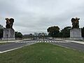
View north on the parkway at the Lincoln Memorial Circle, including the sculpture group The Arts of Peace
-
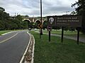
View south at the north end of the parkway
-
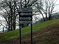
Signage indicates the times during which the Parkway is one-way.
-
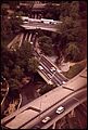
Aerial view of the L Street Bridge and Rock Creek Parkway Trail, at center, 1973


