
Rockingham Lakes Regional Park facts for kids
Quick facts for kids Rockingham Lakes Regional ParkWestern Australia |
|
|---|---|

Lake Cooloongup
|
|

Rockingham Lakes Regional Park
Location in Western Australia
|
|
| Nearest town or city | City of Rockingham |
| Established | 1997 |
| Area | 4,270 hectares |
| Managing authorities | Department of Biodiversity, Conservation and Attractions |
| Website | Rockingham Lakes Regional Park |
The Rockingham Lakes Regional Park is a special conservation park located about 40 kilometers south of Perth, Western Australia. It's found within the City of Rockingham. This park was created in 1997. It covers a total area of 4,270 hectares, which is about 16 percent of the City of Rockingham's land.
In Western Australia, regional parks are places chosen for their amazing nature, beautiful views, and fun activities. This park protects parts of the old Swan Coastal Plain. It also has two rare natural communities: Thrombolites (living rock-like structures) and Sedgelands (areas with grass-like plants). The park even shows how sea levels have changed over the last 7,000 years!
Contents
Park History
The idea for public regional parks in Western Australia started a long time ago. In 1955, a report called the Stephenson-Hepburn Report suggested saving private land for people to use later. This land would become part of the Perth Metropolitan Region in 1963.
Later, in 1983, the Environmental Protection Authority (EPA) found areas that were important for nature, scenery, and recreation. In 1989, the government gave the job of looking after regional parks to the Department of Conservation and Land Management.
A special group was set up in 1990 to create these parks. Even though there were some challenges, the state government officially announced the Rockingham Lakes Regional Park in 1997.
Exploring the Park's Areas
The Rockingham Lakes Regional Park is made up of several important sections. It's not one big continuous area. Some parts are separated by roads or other land. The park covers 4,270 hectares. Most of it is surrounded by towns and businesses, but in the south, it touches farming areas.
Here are some of the main parts of the park:
- Cape Peron: This area has rough limestone cliffs, sandy beaches, and reefs in the ocean. It's located in Peron.
- Lake Richmond: This is a freshwater lake, about 40 hectares in size and up to 15 meters deep. It's home to many birds like Australian pelicans, black swans, and white-faced herons. You can also find thrombolites here. It's located near Rockingham and Shoalwater.
- Lake Cooloongup: This is a salty lake, between 0.5 and 3.5 meters deep. It's in Cooloongup.
- Lake Walyungup: This is another salt lake, about 430 hectares in size and up to 3.5 meters deep. It's a popular spot for landsailors. It's located in Warnbro.
- Port Kennedy Scientific Park: This area is in Port Kennedy.
- Lark Hill: This section is also in Port Kennedy.
- Tamworth Hill: Found in Baldivis.
- Tamworth Hill Swamp: Also in Baldivis.
- Anstey Swamp: Located in Karnup.
- Paganoni Swamp: This swamp and upland area in Karnup is home to different trees like tuart and jarrah. You might also see animals like brushtail possums, bobtails, and Carnaby’s cockatoos here.
Cape Peron and Lake Richmond form a separate block in the northwest. Anstey and Paganoni Swamp are another separate part in the south. The Port Kennedy Scientific Park and Lark Hill are separated from the lakes by a big road and rail corridor.
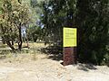
Safety: Unexploded Ordnance

Some parts of the park, like Lake Cooloongup, Lake Walyungup, Port Kennedy Scientific Park, and Lark Hill, might have old, unexploded ammunition. This is because these areas were used as an artillery range by the Department of Defence around the time of World War II. It's very important to stay on marked paths and follow all safety signs in these areas.
More Information
- Parks and Wildlife Service: Rockingham Lakes Regional Park
- Urban Bushland Council WA Inc.: Rockingham Lakes Regional Park
Images for kids
-
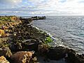
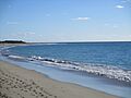
Rugged limestone cliffs at Cape Peron.
-
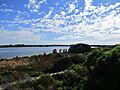
Lake Richmond, a freshwater lake.
-
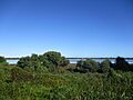
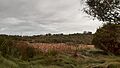
Lake Cooloongup.
-
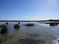
Lake Walyungup, a salt lake popular for landsailing.
-
Becher Point, part of Port Kennedy Scientific Park.
-
Tamworth Hill.
-
Tamworth Hill Swamp.
-
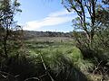
Anstey Swamp.
-

Paganoni Swamp, home to various wildlife.


