Roll, Arizona facts for kids
Quick facts for kids
Roll, Arizona
|
|
|---|---|

Historic Mohawk Valley School
|
|
| Country | United States |
| State | Arizona |
| County | Yuma |
| Elevation | 262 ft (80 m) |
| Population
(2000)
|
|
| • Total | 1,235 |
| Time zone | UTC-7 (Mountain (MST)) |
| ZIP codes |
85347
|
| GNIS feature ID | 10481 |
Roll is a small community located in the middle of Yuma County, Arizona, in the United States. It's known as a populated place, which means it's a community without its own local government. Roll is part of the larger Yuma area.
This community was named after an early settler, John H. Roll. It sits near the Gila River in a spot called the Mohawk Valley. Roll is located between two important areas: the Yuma Proving Ground and the Barry M. Goldwater Air Force Range.
You can find Roll along the Union Pacific Railroad's tracks. Local roads connect Roll to Interstate 8, which is a major highway. This highway is east of the city of Yuma, which is the main city and government center for Yuma County. Roll is about 262 feet (80 meters) above sea level.
Even though Roll doesn't have its own city government, it does have a post office. The ZIP Code for Roll is 85347. In the year 2000, about 1,235 people lived in the area covered by this ZIP Code.
Education in Roll
Students in Roll attend schools within the Mohawk Valley Elementary School District. This district helps provide education for the children living in the community.
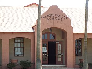
Historic Mohawk Valley School
The old Mohawk Valley School building is a very special place in Roll. It's located at 5151 South Ave. 39 East. This historic school was added to the National Register of Historic Places on December 29, 1986. This means it's recognized as an important historical site in the country. The Wellton Mohawk Middle School is also part of this school system.
Notable People
- Yolanda Bejarano: She is known as a union organizer, which means she helps workers come together to improve their working conditions and rights.
Images for kids
 | Jackie Robinson |
 | Jack Johnson |
 | Althea Gibson |
 | Arthur Ashe |
 | Muhammad Ali |


