Roseland, California facts for kids
Quick facts for kids
Roseland
|
|
|---|---|

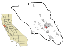
Location in Sonoma County and the state of California
|
|
| Country | |
| State | |
| County | Sonoma |
| City | Santa Rosa |
| Annexed | 2017 |
| Area | |
| • Total | 0.940 sq mi (2.435 km2) |
| • Land | 0.940 sq mi (2.435 km2) |
| • Water | 0 sq mi (0 km2) 0% |
| Elevation | 135 ft (41 m) |
| Population
(2010)
|
|
| • Total | 6,325 |
| • Density | 6,729/sq mi (2,597.5/km2) |
| Ethnicity | |
| • White | 51.1% |
| • Black | 2.1% |
| • Latino | 59.7% |
| • Asian | 4.4% |
| • Native American | 3.5% |
| • Other | 32.9% |
| Time zone | UTC-8 (Pacific) |
| • Summer (DST) | UTC-7 (PDT) |
| ZIP code |
95407
|
| Area code | 707 |
| FIPS code | 06-62868 |
| GNIS feature IDs | 1799481, 2409212 |
Roseland is a neighborhood located in Santa Rosa, California. In 2010, about 6,325 people lived there. Roseland used to be a separate area, but it officially became part of Santa Rosa on November 1, 2017.
This neighborhood is just south of downtown Santa Rosa. It is well-known for its busy shopping area along Sebastopol Road.
Contents
Exploring Roseland's Location
Roseland is found southwest of where two major roads, US-101 and CA-12, meet. It is surrounded by other Santa Rosa neighborhoods.
- To the northeast is downtown Santa Rosa.
- To the north are Lincoln Square, West End, and Railroad Square.
- To the east is South Park.
- To the south is Bellevue Ranch.
- To the west is the Wright area.
Roseland was once a special area called a census-designated place in Sonoma County. This changed when it joined the City of Santa Rosa in 2017. The neighborhood covers about 0.94 square miles (2.435 square kilometers) of land.
Transportation and Trails
The Sonoma–Marin Area Rail Transit (SMART) train line runs through the eastern part of Roseland. There is also a path for bikes and walkers next to the train tracks. This path connects to the Joe Rodota Trail at California State Route 12.
Who Lives in Roseland?
This section shares information about the people living in Roseland, based on past counts.
Population in 2010
In 2010, Roseland had a population of 6,325 people. This means there were about 6,726 people per square mile.
The people living in Roseland came from many different backgrounds:
- About 51.1% were White.
- About 2.1% were African American.
- About 3.5% were Native American.
- About 4.4% were Asian.
- About 0.2% were Pacific Islander.
- About 32.9% were from other races.
- About 5.8% were from two or more races.
Many people in Roseland are of Hispanic or Latino background, making up about 59.7% of the population. Most of them (53.6%) are of Mexican heritage.
Most people (98.9%) lived in homes, while a small number (1.1%) lived in group housing.
Households and Families
There were 1,724 households in Roseland in 2010.
- About 49.5% of households had children under 18.
- About 46.6% were married couples.
- About 16.0% were homes with a female head of household and no husband.
- About 10.0% were homes with a male head of household and no wife.
The average household had about 3.63 people. There were 1,252 families, with an average of 3.97 people per family.
Age Groups
The ages of people in Roseland in 2010 were:
- About 28.9% were under 18 years old.
- About 12.0% were 18 to 24 years old.
- About 30.0% were 25 to 44 years old.
- About 22.4% were 45 to 64 years old.
- About 6.8% were 65 or older.
The average age in Roseland was 30.2 years.
Population in 2000
In 2000, Roseland had 6,369 people. There were 1,847 households and 1,348 families. The population density was about 6,033 people per square mile.
The racial makeup in 2000 was:
- About 57.65% White.
- About 43.22% Latino.
- About 2.68% African American.
- About 2.65% Native American.
- About 5.29% Asian.
- About 0.50% Pacific Islander.
- About 25.15% from other races.
- About 6.06% from two or more races.
Income and Poverty
In 2000, the average household income was $45,955. The average family income was $46,799. About 17.3% of the population lived below the poverty line. This included 20.7% of those under 18.
| Historical population | |||
|---|---|---|---|
| Census | Pop. | %± | |
| 1950 | 1,552 | — | |
| 1960 | 4,510 | 190.6% | |
| 1970 | 5,105 | 13.2% | |
| 1980 | 7,915 | 55.0% | |
| 1990 | 8,779 | 10.9% | |
| 2000 | 6,369 | −27.5% | |
| 2010 | 6,325 | −0.7% | |
Education in Roseland
The Roseland School District helps students from kindergarten through high school.
Elementary Schools
There are three elementary schools for students from transitional kindergarten to sixth grade:
- Roseland Elementary: A Leadership Academy
- Sheppard Accelerated Elementary
- Roseland Creek Elementary
Middle Schools
Two middle schools serve students in seventh and eighth grade:
- Roseland Accelerated Middle School
- Roseland Collegiate Prep
High Schools
Students in ninth through twelfth grade can attend:
- Elsie Allen High School
- Roseland University Prep
- Roseland Collegiate Prep
Community Library
The Sonoma County Library system runs the Roseland Community Library. It is located on Sebastopol Road.
See also
 In Spanish: Roseland (California) para niños
 | Shirley Ann Jackson |
 | Garett Morgan |
 | J. Ernest Wilkins Jr. |
 | Elijah McCoy |

