
Roseland, Nebraska facts for kids
Quick facts for kids
Roseland, Nebraska
|
|
|---|---|
|
Village
|
|

Roseland, seen from the southeast, November 2012
|
|

Location of Roseland, Nebraska
|
|
| Country | United States |
| State | Nebraska |
| County | Adams |
| Area | |
| • Total | 0.28 sq mi (0.71 km2) |
| • Land | 0.28 sq mi (0.71 km2) |
| • Water | 0.00 sq mi (0.00 km2) |
| Elevation | 1,969 ft (600 m) |
| Population
(2020)
|
|
| • Total | 260 |
| • Estimate
(2021)
|
259 |
| • Density | 930/sq mi (366/km2) |
| Time zone | UTC-6 (Central (CST)) |
| • Summer (DST) | UTC-5 (CDT) |
| ZIP code |
68973
|
| Area code(s) | 402 |
| FIPS code | 31-42355 |
| GNIS feature ID | 2399121 |
Roseland is a small village in Adams County, Nebraska, United States. In 2020, about 260 people lived there. Roseland is part of the larger Hastings area.
Contents
History of Roseland
Roseland began in 1887. This was after a railroad was built through the area. The village got its name from the many wild roses that grew nearby. Roseland officially became a village in 1889.
Geography of Roseland
Roseland is a small place. According to the United States Census Bureau, the village covers a total area of about 0.71 square kilometers (0.27 square miles). All of this area is land.
People of Roseland
| Historical population | |||
|---|---|---|---|
| Census | Pop. | %± | |
| 1900 | 227 | — | |
| 1910 | 249 | 9.7% | |
| 1920 | 243 | −2.4% | |
| 1930 | 180 | −25.9% | |
| 1940 | 187 | 3.9% | |
| 1950 | 154 | −17.6% | |
| 1960 | 163 | 5.8% | |
| 1970 | 212 | 30.1% | |
| 1980 | 254 | 19.8% | |
| 1990 | 247 | −2.8% | |
| 2000 | 242 | −2.0% | |
| 2010 | 235 | −2.9% | |
| 2020 | 263 | 11.9% | |
| 2021 (est.) | 259 | 10.2% | |
| U.S. Decennial Census | |||
Roseland in 2010
In 2010, a count called the census showed that 235 people lived in Roseland. These people lived in 91 households, and 68 of these were families. This means there were about 336 people per square kilometer (870 per square mile). There were 98 homes in total.
Out of the 91 households, about 32% had children under 18 living with them. Most households (nearly 65%) were married couples living together. A small number of households had a single parent. About 23% of all households were individuals living alone. About 8% of households had someone aged 65 or older living by themselves.
The average age of people in the village was about 37 years old. About 28% of residents were under 18. About 5% were between 18 and 24. Around 22% were between 25 and 44. About 29% were between 45 and 64. Finally, about 15% were 65 years old or older. The village had slightly more females (50.6%) than males (49.4%).
Images for kids
-
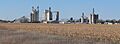
Roseland, seen from the southeast, November 2012
-
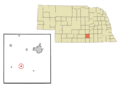
Location of Roseland, Nebraska
See also
 In Spanish: Roseland (Nebraska) para niños
