Rosenheim (district) facts for kids
Quick facts for kids
Rosenheim
|
|
|---|---|
| Country | |
| State | Bavaria |
| Adm. region | Upper Bavaria |
| Region | Südostoberbayern |
| Capital | Rosenheim |
| Area | |
| • Total | 1,439.4 km2 (555.8 sq mi) |
| Population
(2001)
|
|
| • Total | 240,106 |
| • Density | 166.810/km2 (432.035/sq mi) |
| Time zone | UTC+1 (CET) |
| • Summer (DST) | UTC+2 (CEST) |
| Vehicle registration | RO |
| Website | landkreis-rosenheim.de |
The Rosenheim district is a special area, or Landkreis, located in the southern part of Bavaria, Germany. It shares borders with several other districts: Miesbach, Munich, Ebersberg, Mühldorf, and Traunstein. To the south, it borders the Austrian region of Tirol.
The district completely surrounds the city of Rosenheim. Even though the city manages itself, it's where the district's main offices are located. Both the city and the district use "RO" on their car license plates.
Contents
A Look at Rosenheim's Past
How the District Was Formed
The Rosenheim district as we know it today was created in 1972. Before that, it was made up of three smaller areas: the old Rosenheim district, Bad Aibling, and parts of Wasserburg am Inn. These areas were joined together to form the larger district you see on the map now.
Exploring Rosenheim's Geography
Mountains, Lakes, and Rivers
The Rosenheim district is found in the lower parts of the Alps, in a region called the Chiemgau. The land here was shaped by huge ice sheets, called glaciers, during the last Ice Age. These glaciers left behind many hills, called moraines, and lots of beautiful lakes.
The biggest lake in the district is the Chiemsee, which is located to the east. The two main rivers flowing through the district are the Inn and the Mangfall. These two rivers meet up in the city of Rosenheim.
Highest Points in the District
In the southern part of the district, you'll find some mountain ranges. These include the Chiemgauer Alpen and the Mangfallgebirge. The highest point in the entire district is a mountain called the Wendelstein. It stands tall at 1,838 meters (about 6,030 feet) high.
Understanding the Rosenheim Coat of Arms
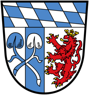
The coat of arms for the Rosenheim district tells a story about its history and geography.
- At the top, you can see the special Bavarian fusily pattern. This pattern looks like blue and white diamonds and is a symbol of Bavaria.
- On the left side, there are crossed leaves from a water lily. These come from the coat of arms of Frauenchiemsee, an island in the Chiemsee lake. They represent the beautiful lake area within the district.
- The red lion on the right side stands for the city of Wasserburg am Inn.
This coat of arms was officially approved in 1976.
Towns and Communities in Rosenheim
The Rosenheim district is made up of several towns and many smaller communities, called municipalities. Here's a list of them:
Main Towns
- Bad Aibling
- Kolbermoor
- Wasserburg am Inn
Market Towns (Markt)
These are towns that used to have special trading rights.
- Bad Endorf
- Bruckmühl
- Neubeuern
- Prien am Chiemsee
Other Municipalities
- Albaching
- Amerang
- Aschau im Chiemgau
- Babensham
- Bad Feilnbach
- Bernau am Chiemsee
- Brannenburg
- Breitbrunn am Chiemsee
- Chiemsee
- Edling
- Eggstätt
- Eiselfing
- Feldkirchen-Westerham
- Flintsbach
- Frasdorf
- Griesstätt
- Großkarolinenfeld
- Gstadt am Chiemsee
- Halfing
- Höslwang
- Kiefersfelden
- Nußdorf am Inn
- Oberaudorf
- Pfaffing
- Prutting
- Ramerberg
- Raubling
- Riedering
- Rimsting
- Rohrdorf
- Rott am Inn
- Samerberg
- Schechen
- Schonstett
- Söchtenau
- Soyen
- Stephanskirchen
- Tuntenhausen
- Vogtareuth
See also
 In Spanish: Distrito de Rosenheim para niños
 | Lonnie Johnson |
 | Granville Woods |
 | Lewis Howard Latimer |
 | James West |


