Roseville, Michigan facts for kids
Quick facts for kids
Roseville, Michigan
|
|
|---|---|

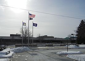
Roseville City Hall
|
|

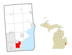
Location within Macomb County
|
|
| Country | |
| State | |
| County | |
| Incorporated | 1926 (village) 1958 (city) |
| Government | |
| • Type | Council–manager |
| Area | |
| • Total | 9.86 sq mi (25.55 km2) |
| • Land | 9.84 sq mi (25.48 km2) |
| • Water | 0.03 sq mi (0.07 km2) |
| Elevation | 614 ft (187 m) |
| Population
(2020)
|
|
| • Total | 47,710 |
| • Density | 4,850.55/sq mi (1,872.74/km2) |
| Time zone | UTC-5 (Eastern (EST)) |
| • Summer (DST) | UTC-4 (EDT) |
| ZIP Code |
48066
|
| Area code(s) | 586 |
| FIPS code | 26-69800 |
| GNIS feature ID | 0636239 |
Roseville is a city in Macomb County, Michigan. It is a northern suburb of Detroit. Roseville is about 13 miles (21 km) northeast of downtown Detroit. In 2020, the city had a population of 47,710 people.
Contents
History of Roseville
The first post office in the area opened in 1840. It was started by William Rose. He named it "Roseville" to honor his father, Dennison Rose. His father was a soldier in the War of 1812.
Roseville became a village in 1926. The city hall building was built in 1929. It first held city offices, police, and fire departments. Later, separate police and fire stations were built. City offices stayed in the building until 1974.
Michigan's first commercial airport, Packard Field, opened in 1919. It was located at Gratiot Avenue and Frazho Road. The airport was later renamed Gratiot Airport and then Hartung Field. A shopping center was built on this site in the 1950s.
The Erin-Roseville Library started in 1936. It was first in one room of the city hall building. The library moved to its own building in the 1960s. In 1974, it moved into the new civic center. By 2010, the library was lending about 250,000 items each year.
In 1958, Roseville officially became a city. This included the village and other parts of Erin Township.
The Macomb Mall opened in 1964. It was one of the first large shopping malls in the region. The mall is still open today.
Geography and Location
Roseville is in the southern part of Macomb County. It is about 14 miles (23 km) northeast of downtown Detroit. The city has several neighbors. To the east is St. Clair Shores. To the south is Eastpointe. Warren is to the west. Fraser and Clinton Township are to the north. Mount Clemens, the county seat, is about 7 miles (11 km) northeast.
Roseville covers a total area of about 9.86 square miles (25.55 km²). Most of this area is land. Only a small part, about 0.03 square miles (0.07 km²), is water.
Main Roads in Roseville
Several important roads run through or near Roseville.
 I-94 is a major highway. It runs along the eastern edge of the city. Between 10 Mile and 12 Mile Roads, it forms the border with St. Clair Shores.
 I-696 (Walter P. Reuther Freeway) goes east and west. It crosses through the middle of Roseville.
 M-3 (Gratiot Avenue) is a main road that runs northeast and southwest. It divides the city into two parts. This road connects Detroit to Mount Clemens and other towns to the north.
 M-97 (Groesbeck Highway) is near the western edge of Roseville. It is a fast road that connects Detroit to northern Macomb County.
Other Important Roads
- East-west travel mostly happens on the mile roads. These include 10 Mile Road on the south border and 14 Mile Road on the north border.
- Utica Road is another key diagonal road. It goes from the southeast to the northwest of the city. It continues into Fraser, Clinton Township, Sterling Heights, and Utica.
Nearby Cities and Towns
Roseville is surrounded by several communities:
 |
Fraser | Clinton Township |  |
|
| Warren | St. Clair Shores | |||
| Eastpointe |
Population Information
Roseville's population has changed over the years.
| Historical population | |||
|---|---|---|---|
| Census | Pop. | %± | |
| 1930 | 6,836 | — | |
| 1940 | 9,023 | 32.0% | |
| 1950 | 15,816 | 75.3% | |
| 1960 | 50,195 | 217.4% | |
| 1970 | 60,529 | 20.6% | |
| 1980 | 54,311 | −10.3% | |
| 1990 | 51,412 | −5.3% | |
| 2000 | 48,129 | −6.4% | |
| 2010 | 47,299 | −1.7% | |
| 2020 | 47,710 | 0.9% | |
| U.S. Decennial Census | |||
2010 Census Data
In 2010, there were 47,299 people living in Roseville. There were 19,553 households. The city had a mix of different groups of people. Most residents were White, with a notable percentage of African American residents.
Schools in Roseville
Public schools in Roseville are run by two main districts. These are Roseville Community Schools and Fraser Public Schools.
- Roseville Community Schools has seven elementary schools. It also has two middle schools and one high school.
- Fraser Public Schools operates two elementary schools within the city.
The charter school Conner Creek Academy East is also located in Roseville.
A Catholic school, St. Angela School, operated from about 1954 until the 2010s.
Famous People from Roseville
Some notable people have come from Roseville:
- Joe Block (born 1978), a baseball announcer for the Pittsburgh Pirates.
- Crystal Reed (born 1985), an actress.
- Walter C. Wetzel (1919–1945), who received the Medal of Honor after he died for his brave actions in 1945.
See also
 In Spanish: Roseville (Míchigan) para niños


