Rossel Island facts for kids
|
Native name:
Yela Island
|
|
|---|---|

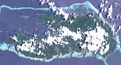
Rossel as seen from space.
|
|
| Geography | |
| Location | Oceania |
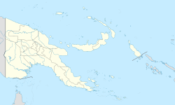
| Coordinates | 11°21′S 154°09′E / 11.350°S 154.150°E |
| Archipelago | Louisiade Archipelago |
| Adjacent bodies of water | Solomon Sea |
| Total islands | 1 |
| Major islands |
|
| Area | 292.5 km2 (112.9 sq mi) |
| Length | 34 km (21.1 mi) |
| Width | 11 km (6.8 mi) |
| Highest elevation | 838 m (2,749 ft) |
| Highest point | Mount Rossel |
| Administration | |
| Province | |
| District | Samarai-Murua District |
| LLG | Yaleyamba Rural Local Level Government Area |
| Island Group | Rossell Islands |
| Largest settlement | Jinjo (pop. ~900) |
| Demographics | |
| Population | 5553 (2014) |
| Pop. density | 19 /km2 (49 /sq mi) |
| Ethnic groups | Papauans, Austronesians, Melanesians. |
| Additional information | |
| Time zone | |
| ISO code | PG-MBA |
Rossel Island, also known as Yela, is the easternmost island in the Louisiade Archipelago. It is part of the Milne Bay Province in Papua New Guinea. The island was named after de Rossel, an officer on a French expedition in the late 1700s. Nearby islands include Tree Islet to the northwest and Wule Island to the west.
Contents
Island Geography and Features
Rossel Island is a mountainous place. It stretches about 34 kilometers (21 miles) from east to west and is up to 11 kilometers (7 miles) wide. With an area of 292.5 square kilometers (113 square miles), it is the second-largest island in its archipelago, after Vanatinai.
During the southeast monsoon season, the higher parts of the island are often covered in clouds. The mountains have short, narrow ridges with occasional peaks. These ridges are smooth and covered in green plants.
Most of the coastline has mangrove trees or thick jungle. Some sandy beaches can be found too. On the north side, very steep hills go down to the shore. The south side of the island has many points and bays, with steep hills leading down to the sea.
Mount Rossel: The Highest Point
The highest point on the island is Mount Rossel. It is located near the eastern end and rises 838 meters (2,749 feet) high. This peak has steep ridges reaching north and west. However, it slopes more gently to the southeast, towards Cape Deliverance.
The southwest ridge has two noticeable peaks, each 549 meters (1,801 feet) high. The eastern peak, Mount Mo, has a flat top. The western peak is shaped like a cone. At the western end of the island, there is another cone-shaped peak that is 347 meters (1,138 feet) high.
Rossel Reef and Lagoon
A coral reef surrounds Rossel Island. This reef creates two large water areas called lagoons. The bigger one, Rossel Lagoon, is in the west. It stretches almost 40 kilometers (25 miles) from the island's northwest point.
The reef around this lagoon is narrow and has four openings on the west side of the island. The reef on the south side of the island is continuous. The water in the lagoon is usually 37 to 64 meters (121 to 210 feet) deep. There are many scattered shallow areas, but most of them are just below the surface. Because the water is so clear, these shallow spots can often be seen easily when the light is good.
Island Climate
Yela Island has a tropical rainforest climate. This means it gets a lot of rain all year round. The main village, Jinjo, experiences this climate.
| Climate data for Jinjo | |||||||||||||
|---|---|---|---|---|---|---|---|---|---|---|---|---|---|
| Month | Jan | Feb | Mar | Apr | May | Jun | Jul | Aug | Sep | Oct | Nov | Dec | Year |
| Mean daily maximum °C (°F) | 30.8 (87.4) |
31.2 (88.2) |
30.7 (87.3) |
29.6 (85.3) |
29.0 (84.2) |
28.4 (83.1) |
28.0 (82.4) |
28.1 (82.6) |
28.7 (83.7) |
30.1 (86.2) |
30.7 (87.3) |
31.2 (88.2) |
29.7 (85.5) |
| Daily mean °C (°F) | 27.0 (80.6) |
27.4 (81.3) |
27.1 (80.8) |
26.6 (79.9) |
26.2 (79.2) |
25.8 (78.4) |
25.4 (77.7) |
25.5 (77.9) |
26.0 (78.8) |
26.9 (80.4) |
27.2 (81.0) |
27.5 (81.5) |
26.6 (79.8) |
| Mean daily minimum °C (°F) | 23.4 (74.1) |
23.6 (74.5) |
23.6 (74.5) |
23.6 (74.5) |
23.4 (74.1) |
23.2 (73.8) |
22.9 (73.2) |
22.9 (73.2) |
23.3 (73.9) |
23.7 (74.7) |
23.7 (74.7) |
23.8 (74.8) |
23.4 (74.2) |
| Average precipitation mm (inches) | 311 (12.2) |
355 (14.0) |
325 (12.8) |
377 (14.8) |
315 (12.4) |
243 (9.6) |
229 (9.0) |
225 (8.9) |
264 (10.4) |
285 (11.2) |
223 (8.8) |
282 (11.1) |
3,434 (135.2) |
| Source: Climate-Data.org | |||||||||||||
Island History
Europeans first saw and mapped Rossel Island on July 14, 1606. This was done by a Spanish expedition led by Luís Vaz de Torres. They named it Tierra de San Buenaventura.
The island was later named after Elisabeth Paul Eduard de Rossel. He was a French astronomer who was part of an expedition looking for a missing French explorer in the late 1700s.
In 1858, a French ship called Saint Paul was shipwrecked near the island. It was carrying over 300 Chinese workers on their way to Australia. Sadly, many of the people on board did not survive the shipwreck and its aftermath.
Plants and Animals
Rossel Island is covered in thick forests. The entire south coast is a dense jungle. Sometimes, you can find patches of grass.
- One special plant, Guioa plurinervis, grows only on this island.
- Another plant group, Rosselia, was named after the island. These plants are found in New Guinea.
Island Population
In 2014, about 5,553 people lived on Rossel Island. They were spread across 31 villages. The largest village is Jinjo, located on the east coast. The local people speak a unique language called Yélî Dnye language. Experts are still trying to understand how this language is related to others.
See also
 In Spanish: Isla Rossel para niños
 | Jackie Robinson |
 | Jack Johnson |
 | Althea Gibson |
 | Arthur Ashe |
 | Muhammad Ali |


