Rossie, New York facts for kids
Quick facts for kids
Rossie, New York
|
|
|---|---|

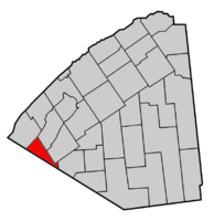
Map highlighting Rossie's location within St. Lawrence County.
|
|
| Country | United States |
| State | New York |
| County | St. Lawrence |
| Area | |
| • Total | 39.24 sq mi (101.64 km2) |
| • Land | 37.79 sq mi (97.88 km2) |
| • Water | 1.45 sq mi (3.76 km2) |
| Elevation | 459 ft (140 m) |
| Population
(2020)
|
|
| • Total | 799 |
| • Density | 22.33/sq mi (8.62/km2) |
| Time zone | UTC-5 (Eastern (EST)) |
| • Summer (DST) | UTC-4 (EDT) |
| FIPS code | 36-63858 |
| GNIS feature ID | 0979436 |
Rossie is a small town located in St. Lawrence County, New York, in the United States. In 2020, about 799 people lived there. The town was named after the sister of one of its first landowners.
You can find the Town of Rossie on the southwestern edge of St. Lawrence County. It is located to the west of the village of Gouverneur.
Contents
History of Rossie
Early Settlers and Town Formation
The very first settler arrived in the area around 1807. Just a few years later, in 1813, the town of Rossie was officially formed. It was created from a part of the Town of Russell.
Rossie During the War of 1812
During the War of 1812, the people living in Rossie built a special wooden fort called a blockhouse. This blockhouse was located in the southern part of the town and helped protect the residents.
Important Industries in Early Rossie
The iron industry was very important to Rossie's economy in its early days. The Rossie Furnace, built in 1815, was the first iron furnace in all of northern New York. This shows how important Rossie was for making iron.
Lead mining was also a big part of the town's economy. Lead was used for many things, including making bullets. The Rossie Shot Tower, a tall building used to make lead shot, is still standing today. It's a cool reminder of Rossie's industrial past.
Geography of Rossie
Land and Water Areas
According to the United States Census Bureau, the town of Rossie covers a total area of about 39.1 square miles (101.64 square kilometers). Most of this area, about 38.1 square miles (97.88 square kilometers), is land. The rest, about 1.0 square mile (3.76 square kilometers), is covered by water.
Borders and Rivers
The southwestern border of Rossie is also the border of Jefferson County. This means Rossie is right next to another county.
The Oswegatchie River flows through the southern part of Rossie. What's interesting is that the river loops back on itself, so it seems to flow in two different directions in that area!
Roads and Lakes
U.S. Route 11, a major road, goes right through the town of Rossie.
Several lakes are also partly located within the town. These include Yellow Lake and Grass Lake. A very small bay of Black Lake can also be found at the northern end of Rossie.
Population of Rossie
The population of Rossie has changed over the years. Here's how many people have lived in the town during different census years:
| Historical population | |||
|---|---|---|---|
| Census | Pop. | %± | |
| 1820 | 869 | — | |
| 1830 | 650 | −25.2% | |
| 1840 | 1,553 | 138.9% | |
| 1850 | 1,471 | −5.3% | |
| 1860 | 1,609 | 9.4% | |
| 1870 | 1,661 | 3.2% | |
| 1880 | 1,709 | 2.9% | |
| 1890 | 1,493 | −12.6% | |
| 1900 | 1,136 | −23.9% | |
| 1910 | 981 | −13.6% | |
| 1920 | 866 | −11.7% | |
| 1930 | 720 | −16.9% | |
| 1940 | 706 | −1.9% | |
| 1950 | 611 | −13.5% | |
| 1960 | 649 | 6.2% | |
| 1970 | 643 | −0.9% | |
| 1980 | 842 | 30.9% | |
| 1990 | 770 | −8.6% | |
| 2000 | 787 | 2.2% | |
| 2010 | 877 | 11.4% | |
| 2020 | 799 | −8.9% | |
In 2000, there were 787 people living in Rossie. There were 298 households, and 214 of these were families. About 35.2% of the households had children under 18 living with them. The average household had about 2.64 people. The median age in the town was 35 years old.
Communities and Locations in Rossie
Rossie is made up of several smaller communities and specific locations:
- Keenes – This is a small hamlet (a tiny village) located on the western border of the town, in its southern part.
- Nelson Corner – You can find this spot in the northern part of the town, just west of the main Rossie village.
- Pikes Corner – Another hamlet, located in the southern part of the town along County Road 9.
- Rossie – This is the main hamlet of Rossie. It's located in the northern part of the town where County Road 3 and County Road 8 meet.
- Sommerville – A hamlet in the southern part of the town, found along U.S. Route 11.
- Spragueville – This hamlet was once called "Spragues Corners." It's located on County Road 9, right at the county line in the southern part of the town.
- Wegatchie – A hamlet situated in the southern part of the town, along County Road 12.
See also
In Spanish: Rossie (Nueva York) para niños


