Rothville, Missouri facts for kids
Quick facts for kids
Rothville, Missouri
|
|
|---|---|
|
Village
|
|

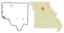
Location of Rothville, Missouri
|
|
| Country | United States |
| State | Missouri |
| County | Chariton |
| Area | |
| • Total | 0.20 sq mi (0.51 km2) |
| • Land | 0.20 sq mi (0.51 km2) |
| • Water | 0.00 sq mi (0.00 km2) |
| Elevation | 735 ft (224 m) |
| Population
(2020)
|
|
| • Total | 63 |
| • Density | 319.80/sq mi (123.22/km2) |
| Time zone | UTC-6 (Central (CST)) |
| • Summer (DST) | UTC-5 (CDT) |
| ZIP code |
64676
|
| Area code(s) | 660 |
| FIPS code | 29-63236 |
| GNIS feature ID | 2399130 |
Rothville is a small village in northern Chariton County, Missouri, United States. In 2020, about 63 people lived there. It is a quiet community with a bit of interesting history.
Contents
A Look Back: Rothville's History
Rothville was officially started in 1883. The village got its name from John Roth, who was a local merchant, meaning he owned a store or traded goods. A post office, where people could send and receive mail, was opened in Rothville in 1868.
A very famous writer named Laura Ingalls-Wilder lived in the area for a short time. She was there from 1868 to 1869. She is best known for her "Little House on the Prairie" books.
Where is Rothville?
Rothville is located in Missouri. You can find it along Missouri Route E. It is about ten miles east of Sumner. It is also six miles northeast of Mendon. Another town, Marceline, is six miles southwest of Rothville.
Two creeks, East Yellow Creek and West Yellow Creek, join together just east of the village. They form a larger stream called Yellow Creek. The Atchison Topeka and Santa Fe Railroad train tracks also run along the southeast side of the community.
The United States Census Bureau says that Rothville covers a total area of about 0.20 square miles. All of this area is land, with no large bodies of water.
Who Lives in Rothville?
| Historical population | |||
|---|---|---|---|
| Census | Pop. | %± | |
| 1910 | 245 | — | |
| 1920 | 220 | −10.2% | |
| 1930 | 183 | −16.8% | |
| 1940 | 180 | −1.6% | |
| 1950 | 152 | −15.6% | |
| 1960 | 138 | −9.2% | |
| 1970 | 131 | −5.1% | |
| 1980 | 118 | −9.9% | |
| 1990 | 100 | −15.3% | |
| 2000 | 93 | −7.0% | |
| 2010 | 99 | 6.5% | |
| 2020 | 63 | −36.4% | |
| U.S. Decennial Census | |||
Rothville's Population in 2010
According to the census from 2010, there were 99 people living in Rothville. These people lived in 37 different homes, and 29 of these were families. Most of the people living in the village, about 99.0%, were White. About 1.0% of the people were from two or more different backgrounds.
A small number, 3.0%, were Hispanic or Latino. In 37 homes, about 43.2% had children under 18 living there. Most homes, 59.5%, had married couples living together.
About 13.5% of homes had a female head of the house without a husband. Another 5.4% had a male head of the house without a wife. About 21.6% of all homes were made up of people who were not related as a family.
The average home had about 2.68 people. The average family had about 3.10 people. The average age of people in the village was 33.2 years old. About 31.3% of residents were under 18 years old. About 35.4% were between 25 and 44 years old.
About 27.4% were between 45 and 64 years old. Only 6.1% of the people were 65 years old or older. The village had a nearly even number of males and females. About 50.5% were male, and 49.5% were female.
See also
 In Spanish: Rothville (Misuri) para niños
 | Kyle Baker |
 | Joseph Yoakum |
 | Laura Wheeler Waring |
 | Henry Ossawa Tanner |

