Rush River (Minnesota) facts for kids
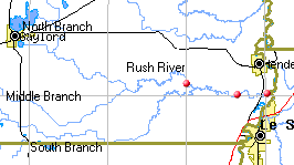
The Rush River is a waterway in the U.S. state of Minnesota. It is about 20 miles (32 kilometers) long. This river flows entirely within Sibley County, Minnesota. However, the area it drains, called its watershed, also includes parts of Nicollet and McLeod counties. The Rush River is a tributary of the Minnesota River. This means it is a smaller river that flows into a larger one.
The Rush River starts where its Middle and North Branches meet. This is around 94.1 degrees west longitude and 44.5 degrees north latitude. From there, it generally flows towards the east. The South Branch joins the main river a bit further east. The Rush River continues flowing east until it meets the Minnesota River. This meeting point is about 2.5 miles (4 kilometers) north-northeast of Le Sueur, Minnesota. The Minnesota River then flows generally north and east until it joins the Mississippi River.
North Branch Rush River
The North Branch Rush River starts from Titlow Lake. This lake is located east of Gaylord, Minnesota. The North Branch flows for about 11.3 miles (18.2 kilometers). It travels southeast until it joins the Middle Branch Rush River. When these two branches meet, they form the main Rush River.
Middle Branch Rush River
The Middle Branch Rush River begins northwest of Gibbon, Minnesota. It flows for about 36.0 miles (57.9 kilometers) towards the east. This branch continues until it meets the North Branch. Together, the Middle and North Branches create the start of the Rush River.
South Branch Rush River
The South Branch Rush River starts between Winthrop and Lafayette. This is about 10 miles (16 kilometers) west-southwest of Gaylord. It is also near the border between Sibley and Nicollet counties. The South Branch flows for about 34.1 miles (54.9 kilometers) to the east. It then joins the main Rush River.
 | Valerie Thomas |
 | Frederick McKinley Jones |
 | George Edward Alcorn Jr. |
 | Thomas Mensah |


