Nicollet County, Minnesota facts for kids
Quick facts for kids
Nicollet County
|
|
|---|---|

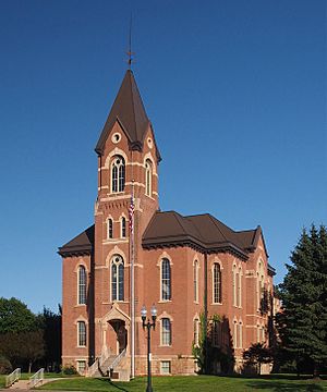
Nicollet County Courthouse
|
|

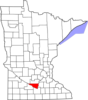
Location within the U.S. state of Minnesota
|
|
 Minnesota's location within the U.S. |
|
| Country | |
| State | |
| Founded | March 5, 1853 |
| Named for | Joseph Nicolas Nicollet |
| Seat | St. Peter |
| Largest city | North Mankato |
| Area | |
| • Total | 467 sq mi (1,210 km2) |
| • Land | 448 sq mi (1,160 km2) |
| • Water | 18 sq mi (50 km2) 3.9%% |
| Population
(2020)
|
|
| • Total | 34,454 |
| • Estimate
(2023)
|
34,242 |
| • Density | 76.9/sq mi (29.7/km2) |
| Time zone | UTC−6 (Central) |
| • Summer (DST) | UTC−5 (CDT) |
| Congressional district | 1st |
Nicollet County is a county in the state of Minnesota. It is located in the United States. In 2020, about 34,454 people lived here. The main city and government center is St. Peter.
Nicollet County is part of a larger area called the Mankato – North Mankato Metropolitan Statistical Area. This means it's connected to the bigger cities of Mankato and North Mankato.
Contents
History of Nicollet County
In 1849, the government of the Minnesota Territory created the borders for nine future counties. One of these, Dakota County, included the land that would become Nicollet County. This area was north of the Minnesota River.
In 1853, the first settlers started living in this area. The next year, the town of Saint Peter was planned there. As more people moved in, the territorial government decided to create a new county. On March 5, 1853, they formed Nicollet County.
The county was named after Joseph Nicolas Nicollet. He was a French explorer. His detailed maps of the area helped a lot in developing the territory. Saint Peter was chosen as the county seat, which is where the county government is located.
During the Dakota War of 1862, some important events happened in the county. One notable event was the Battle of Fort Ridgely.
Geography of Nicollet County
The Minnesota River flows along the southern edge of Nicollet County. It starts in the northwest and flows east to the northeast corner. This river forms the county's southern border.
The land in Nicollet County has gentle, rolling hills. Most of the land is used for farming. The county's total area is about 467 square miles. Of this, 448 square miles is land, and 18 square miles (about 3.9%) is water.
The highest point in Nicollet County is 1,065 feet above sea level. This is the lowest "highest point" compared to all other counties in Minnesota. This high point is located east of Clear Lake and west of the town of Lafayette.
Main Roads in Nicollet County
Counties Next to Nicollet County
- Sibley County - to the north
- Le Sueur County - to the east
- Blue Earth County - to the southeast
- Brown County - to the southwest
- Renville County - to the northwest
Special Parks and Areas
- Fort Ridgely State Park (part of it is in Nicollet County)
- Minneopa State Park (part of it is in Nicollet County)
- Seven Mile Creek County Park
Lakes in Nicollet County
- Annexstad Lake
- Erickson Lake
- Middle Lake
- Oak Leaf Lake
- Overson Lake
- Rice Lake
- Sand Lake
- Swan Lake
Population of Nicollet County
| Historical population | |||
|---|---|---|---|
| Census | Pop. | %± | |
| 1860 | 3,778 | — | |
| 1870 | 8,362 | 121.3% | |
| 1880 | 12,333 | 47.5% | |
| 1890 | 13,382 | 8.5% | |
| 1900 | 14,774 | 10.4% | |
| 1910 | 14,125 | −4.4% | |
| 1920 | 15,036 | 6.4% | |
| 1930 | 16,550 | 10.1% | |
| 1940 | 18,282 | 10.5% | |
| 1950 | 20,929 | 14.5% | |
| 1960 | 23,196 | 10.8% | |
| 1970 | 24,518 | 5.7% | |
| 1980 | 26,929 | 9.8% | |
| 1990 | 28,076 | 4.3% | |
| 2000 | 29,771 | 6.0% | |
| 2010 | 32,727 | 9.9% | |
| 2020 | 34,454 | 5.3% | |
| 2023 (est.) | 34,242 | 4.6% | |
| U.S. Decennial Census 1790-1960 1900-1990 1990-2000 2010-2020 |
|||
The population of Nicollet County has grown steadily over the years. In 1860, there were fewer than 4,000 people. By 2020, the population had grown to over 34,000 people.
Towns and Communities
Cities in Nicollet County
- Courtland
- Lafayette
- Mankato (partly in Blue Earth County)
- Nicollet
- North Mankato (partly in Blue Earth County)
- St. Peter (This is the county seat)
Smaller Communities (Unincorporated)
These are smaller places that are not officially cities.
Ghost Town
- West Newton (A ghost town is a place where most people have left, and it's no longer a lively community.)
Townships
Townships are smaller local government areas within the county.
- Belgrade Township
- Bernadotte Township
- Brighton Township
- Courtland Township
- Granby Township
- Lafayette Township
- Lake Prairie Township
- New Sweden Township
- Nicollet Township
- Oshawa Township
- Ridgely Township
- Traverse Township
- West Newton Township
See also
 In Spanish: Condado de Nicollet para niños
 | Emma Amos |
 | Edward Mitchell Bannister |
 | Larry D. Alexander |
 | Ernie Barnes |


