Courtland, Minnesota facts for kids
Quick facts for kids
Courtland
|
|
|---|---|

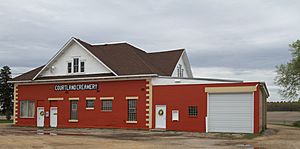
Courtland Creamery
|
|
| Motto(s):
"A Great Place To Call Home"
|
|

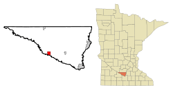
Location of Courtland, Minnesota
|
|
| Country | United States |
| State | Minnesota |
| County | Nicollet |
| Government | |
| • Type | Mayor – Council |
| Area | |
| • Total | 2.62 sq mi (6.78 km2) |
| • Land | 2.61 sq mi (6.76 km2) |
| • Water | 0.01 sq mi (0.02 km2) |
| Elevation | 938 ft (286 m) |
| Population
(2020)
|
|
| • Total | 734 |
| • Density | 281.01/sq mi (108.52/km2) |
| Time zone | UTC-6 (Central (CST)) |
| • Summer (DST) | UTC-5 (CDT) |
| ZIP code |
56021
|
| Area code(s) | 507 |
| FIPS code | 27-13582 |
| GNIS feature ID | 2393654 |
Courtland is a small city located in Nicollet County, Minnesota, United States. In 2020, about 734 people lived there. It is part of the larger Mankato-North Mankato area.
Contents
History of Courtland
The area where Courtland now stands was first named Hilo. In 1865, its name was changed to Courtland. The city was officially planned and marked out on a map in 1882.
There are different ideas about how Courtland got its name. Some records say it was named after Cortland County, New York. Other records suggest it was named after Courland, a region that is now part of Latvia. An early settler, J.H. Stewart, might have come from there. It's thought that the name was accidentally misspelled when it was officially recorded.
Geography of Courtland
According to the U.S. Census Bureau, which collects information about the country, the city covers a total area of about 6.8 square kilometers (2.64 square miles). All of this area is land.
People of Courtland (Demographics)
Demographics is the study of the people who live in a place. This includes things like how many people there are, their ages, and how many families live there.
| Historical population | |||
|---|---|---|---|
| Census | Pop. | %± | |
| 1900 | 174 | — | |
| 1910 | 208 | 19.5% | |
| 1920 | 224 | 7.7% | |
| 1930 | 260 | 16.1% | |
| 1940 | 291 | 11.9% | |
| 1950 | 251 | −13.7% | |
| 1960 | 239 | −4.8% | |
| 1970 | 300 | 25.5% | |
| 1980 | 399 | 33.0% | |
| 1990 | 412 | 3.3% | |
| 2000 | 538 | 30.6% | |
| 2010 | 611 | 13.6% | |
| 2020 | 734 | 20.1% | |
| U.S. Decennial Census 2020 Census |
|||
Courtland in 2010
In 2010, a census (an official count of the population) showed that 611 people lived in Courtland. There were 237 households, which means 237 homes where people lived. Out of these, 176 were families.
The population density was about 231 people per square mile (95 people per square kilometer). This tells us how many people live in a certain amount of space. Most of the people living in Courtland were White (99.0%).
About 34% of the households had children under 18 living with them. Most households (67.1%) were married couples living together. The average household had about 2.58 people.
The median age in the city was 37.7 years old. This means half the people were younger than 37.7 and half were older. About 24% of the residents were under 18 years old. About 9% were 65 years old or older. The city had slightly more males (50.6%) than females (49.4%).
See also
 In Spanish: Courtland (Minnesota) para niños
 | James Van Der Zee |
 | Alma Thomas |
 | Ellis Wilson |
 | Margaret Taylor-Burroughs |

