Rutledge, Georgia facts for kids
Quick facts for kids
Rutledge, Georgia
|
|
|---|---|

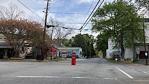
Rutledge downtown
|
|

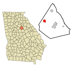
Location in Morgan County and the state of Georgia
|
|
| Country | United States |
| State | Georgia |
| County | Morgan |
| Area | |
| • Total | 3.32 sq mi (8.60 km2) |
| • Land | 3.29 sq mi (8.51 km2) |
| • Water | 0.04 sq mi (0.09 km2) |
| Elevation | 712 ft (217 m) |
| Population
(2020)
|
|
| • Total | 871 |
| • Density | 265.14/sq mi (102.37/km2) |
| Time zone | UTC-5 (Eastern (EST)) |
| • Summer (DST) | UTC-4 (EDT) |
| ZIP code |
30663
|
| Area code(s) | 706 |
| FIPS code | 13-67760 |
| GNIS feature ID | 0322022 |
Rutledge is a small city located in Morgan County, Georgia, in the United States. It was founded a long time ago, in 1871. According to the 2020 census, about 871 people live there. This is a little more than the 781 people who lived there in 2010.
Contents
History of Rutledge
Rutledge began in the 1840s. This was when the railroad tracks were built and reached this area. The government of Georgia, called the Georgia General Assembly, officially made Rutledge a town in 1871.
Where is Rutledge?
Rutledge is located in the western part of Morgan County. Its exact location is 33°37′33″N 83°36′39″W / 33.62583°N 83.61083°W. U.S. Route 278 goes through the southern part of the city. This road leads east about 9 miles (14 km) to Madison, which is the county seat. It also goes west about 15 miles (24 km) to Covington.
You can find Interstate 20 about 2 miles (3 km) south of Rutledge. You can get to it from Exit 105, which is called Newborn Road.
Land and Water
The city of Rutledge covers a total area of about 3.3 square miles (8.5 km2). Most of this area is land. Only a small part, about 0.04 square miles (0.10 km2) or 1.05%, is water.
The southern part of Rutledge has a stream called Rice Creek. This creek flows into Big Indian Creek, which then goes southeast to the Little River. The northern part of the city has Hard Labor Creek. This creek flows east to the Apalachee River. All the water in Rutledge eventually flows into the Oconee River.
Rutledge is also very close to Hard Labor Creek State Park. This park is about 2 miles (3 km) north of the city center.
Who Lives in Rutledge?
| Historical population | |||
|---|---|---|---|
| Census | Pop. | %± | |
| 1870 | 235 | — | |
| 1880 | 273 | 16.2% | |
| 1890 | 588 | 115.4% | |
| 1900 | 469 | −20.2% | |
| 1910 | 696 | 48.4% | |
| 1920 | 643 | −7.6% | |
| 1930 | 523 | −18.7% | |
| 1940 | 550 | 5.2% | |
| 1950 | 482 | −12.4% | |
| 1960 | 478 | −0.8% | |
| 1970 | 628 | 31.4% | |
| 1980 | 694 | 10.5% | |
| 1990 | 659 | −5.0% | |
| 2000 | 707 | 7.3% | |
| 2010 | 781 | 10.5% | |
| 2020 | 871 | 11.5% | |
| U.S. Decennial Census | |||
A census is a count of all the people living in a place. In the year 2000, the census showed that 707 people lived in Rutledge. These people lived in 260 households, and 197 of those were families. By 2020, the population had grown to 871 people.
Rutledge's Economy
Rutledge is connected to the movie industry in Covington. This means that sometimes movies or TV shows are filmed in or near Rutledge.
See also
 In Spanish: Rutledge (Georgia) para niños
 | Emma Amos |
 | Edward Mitchell Bannister |
 | Larry D. Alexander |
 | Ernie Barnes |

