Río Grande de Añasco facts for kids
Quick facts for kids Río Grande de Añasco |
|
|---|---|

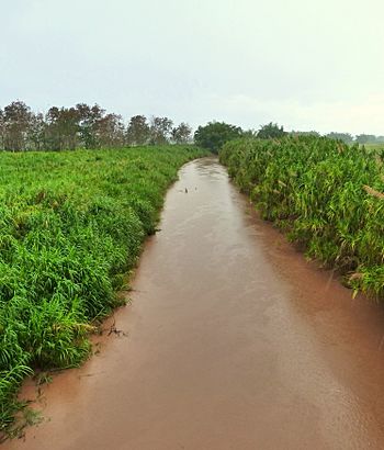
The Río Grande de Añasco in the coastal plain, swollen by rain
|
|
| Commonwealth | Puerto Rico |
| Municipality | Mayagüez |
| Physical characteristics | |
| Main source | 3 ft. |
The Río Grande de Añasco is an important river in western Puerto Rico. It starts high up in the Central Mountain Range. This is near a town called Adjuntas. The river then flows west for about 40 miles (64 km) (that's 64 kilometres (40 mi)). It ends in the Mona Passage, which is the sea between Puerto Rico and the Dominican Republic. This spot is about 4 miles (6.4 km) (6.4 kilometres (4.0 mi)) north of Mayagüez.
The river passes through several towns. These include Mayagüez, Añasco, San Sebastián, and Las Marías. Long ago, the Taíno people who lived in Puerto Rico called this river Río Guaorabo.
River History

In 1898, the United States wrote a report called Military Notes on Puerto Rico. This report described the Añasco River. It said the river starts in the Lares Mountain ridge. It rises near mountains called Tetas de Cerro Gordo.
The river first flows northwest, then turns west. It passes through the town of Añasco before reaching the sea.
A famous bridge crosses the river. It is called the Puente de Añasco. This bridge is so important that it is listed on the National Register of Historic Places. This list includes special places in the United States that are worth protecting.
More About the River
- Puente de Añasco: This is the historic bridge over the river. It is listed in the National Register of Historic Places.
- List of rivers of Puerto Rico: You can find other rivers in Puerto Rico on this list.
See also
 In Spanish: Río Grande de Añasco para niños
 | John T. Biggers |
 | Thomas Blackshear |
 | Mark Bradford |
 | Beverly Buchanan |

