
STS-99 facts for kids

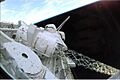
The SRTM radar boom in Endeavour's payload bay, extending 60 meters off the vehicle's port side
|
|
| Mission type | Radar imaging |
|---|---|
| Operator | NASA |
| Mission duration | 11 days, 5 hours, 39 minutes, 41 seconds |
| Distance travelled | 6,540,000 kilometers (4,060,000 mi) |
| Spacecraft properties | |
| Spacecraft | Space Shuttle Endeavour |
| Launch mass | 116,376 kilograms (256,565 lb) |
| Landing mass | 102,363 kilograms (225,672 lb) |
| Payload mass | 13,154 kilograms (29,000 lb) |
| Crew | |
| Crew size | 6 |
| Members |
|
| Start of mission | |
| Launch date | 11 February 2000, 17:43 UTC |
| Launch site | Kennedy LC-39A |
| End of mission | |
| Landing date | 22 February 2000, 23:23 UTC |
| Landing site | Kennedy SLF Runway 33 |
| Orbital parameters | |
| Reference system | Geocentric |
| Regime | Low Earth |
| Perigee | 224 kilometres (139 mi) |
| Apogee | 242 kilometres (150 mi) |
| Inclination | 57.0 degrees |
| Period | 89.2 minutes |
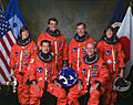
  Left to right - Front: Mohri, Thiele; Back: Voss, Kregel, Gorie, Kavandi |
|
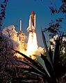
STS-99 was a Space Shuttle mission that used the orbiter Endeavour. It launched on February 11, 2000, from the Kennedy Space Center in Florida. The main goal of this mission was the Shuttle Radar Topography Mission (SRTM). This project aimed to create a very detailed 3D map of Earth's surface.
STS-99 was the last time Endeavour flew a mission by itself. After this, all its future flights were to help build the International Space Station. This mission was also the first Space Shuttle flight of the 2000s.
Contents
Meet the STS-99 Crew
The STS-99 mission had a crew of six astronauts. They worked together to complete the important mapping tasks.
| Position | Astronaut | |
|---|---|---|
| Commander | Fourth and last spaceflight |
|
| Pilot | Second spaceflight |
|
| Mission Specialist 1 | Only spaceflight |
|
| Mission Specialist 2 | Second spaceflight |
|
| Mission Specialist 3 | Fifth and last spaceflight |
|
| Mission Specialist 4 | Second and last spaceflight |
|
Mapping Earth: The SRTM Mission

The Shuttle Radar Topography Mission (SRTM) was a big international project. It was led by the National Geospatial-Intelligence Agency (a U.S. defense agency) and NASA. Germany's space agency (DLR) also helped.
What Was the Goal of SRTM?
The main goal was to create the most complete and detailed digital 3D map of Earth's land surface. To do this, Endeavour carried a special radar system. This system collected about 8 terabytes of data. That's a huge amount of information, enough to fill 20,000 CDs! This data was used to make high-quality 3D images of our planet.
How the Radar System Worked
The SRTM used a special type of radar called interferometric synthetic aperture radar (IFSAR). This radar could measure the height of land features. It mapped areas between 60 degrees north and 56 degrees south of the equator. The measurements were very precise, allowing for maps with 30-meter (about 100 feet) detail.
The mission collected nearly 1 trillion measurements of Earth's surface. These measurements are useful for many things:
- Making better maps.
- Improving models of how water flows.
- Creating more realistic flight simulators.
- Finding better spots for cell phone towers.
- Making navigation safer.
Radar Operations in Space
The SRTM mast, which was like a long arm, successfully extended to its full length of 60 meters (about 200 feet). The radar antenna then moved into its working position. After checking that the radar systems were ready, mapping began less than 12 hours after launch.
The crew split into two shifts. This allowed them to work around the clock. They started mapping from 60 degrees north to 56 degrees south. The data was sent to the Jet Propulsion Laboratory for review. Early results showed the data was excellent.
Challenges During the Mission
Mapping mostly went smoothly. However, on the second day, the shuttle started using more fuel than expected. This was because a small system that helped keep the radar mast stable stopped working. The shuttle had to use its own fuel to stay in the correct position.
Engineers quickly figured out how to save fuel. They found a way to complete the planned 9-day mission.
Special Maneuvers: The "Flycast"
The crew also performed "flycast" maneuvers. These were special moves designed to reduce stress on the long radar mast. When the shuttle needed to adjust its orbit, it would turn tail-first. Then, it would briefly fire its engines. This made the mast bend slightly and then spring back. As it became vertical, a stronger thrust was applied. This helped the shuttle change speed without putting too much strain on the mast.

Mission Completion
Radar data collection finished on the tenth day of the flight. The last area mapped was over Australia. In total, the radar worked for over 222 hours. Endeavour's radar images filled 332 special tapes. They covered 99.98% of the planned mapping area at least once. About 94.6% of the area was mapped twice. Only a small area of about 80,000 square miles (207,000 square kilometers) was not mapped. Most of these areas were already well-mapped by other methods.
Student Experiment: EarthKAM
The shuttle also carried a student experiment called EarthKAM. This project allowed middle school students to choose targets on Earth for the shuttle's camera to photograph. The camera took 2,715 digital photos through a window on the flight deck. Students received the images online. They used them in classroom projects about Earth science, geography, math, and space. Over 75 middle schools worldwide took part, setting a new record for the program.
Shuttle Cockpit Changes
STS-99 was the last mission to fly with the original Space Shuttle cockpit design for many years. The next mission, STS-101, featured a newer "glass cockpit" on Atlantis. However, Endeavour and Discovery continued to use the older cockpit until after the Columbia disaster.
Launch Attempts
The launch of STS-99 was delayed a few times before its successful liftoff.
| Attempt | Planned | Result | Turnaround | Reason | Decision point | Weather go (%) | Notes |
|---|---|---|---|---|---|---|---|
| 1 | 31 Jan 2000, 12:47:00 pm | scrubbed | — | technical | 31 Jan 2000, 2:08 am | 60% | avionics problem |
| 2 | 1 Feb 2000, 12:44:00 pm | scrubbed | 0 days, 23 hours, 57 minutes | technical | 1 Feb 2000, 3:30 am | avionics problem | |
| 3 | 11 Feb 2000, 12:30:00 pm | success | 9 days, 23 hours, 46 minutes | 90% |
Wake-up Calls from Space
NASA has a tradition of playing music to astronauts to wake them up. This started during the Gemini program and was first used on Apollo 15. Each song is chosen carefully, often by the astronauts' families. The songs usually have a special meaning to a crew member or relate to their daily tasks.
| Flight Day | Song | Artist/Composer | Links |
|---|---|---|---|
| Day 2 | "Stardust" | Willie Nelson | wav mp3 Transcript |
| Day 3 | "I Believe I Can Fly" | R. Kelly | wav mp3 Transcript |
| Day 4 | "Sunshine of Your Love" | Cream | wav mp3 Transcript |
| Day 7 | "O Mio Babbino Caro" | Puccini | wav mp3 Transcript |
| Day 8 | "Here Comes the Sun" | The Beatles | wav mp3 Transcript |
| Day 9 | "Rattled" | Traveling Wilburys | wav mp3 Transcript |
| Day 10 | "Back in the Saddle Again" | Gene Autry | wav mp3 Transcript |
| Day 11 | "Beyond the Sea" | Bobby Darin | wav mp3 Transcript |
| Day 12 | "I'll Be Home for Christmas" | Bing Crosby | wav mp3 Transcript |
Images for kids
-
The SRTM radar boom in Endeavour's payload bay, extending 60 meters off the vehicle's port side
-
STS-99 mission insignia
-
Left to right - Front: Mohri, Thiele; Back: Voss, Kregel, Gorie, Kavandi
-
STS-99 launches from Kennedy Space Center, 11 February 2000.
-
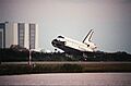
STS-99 ends as Space Shuttle Endeavour lands at the Shuttle Landing Facility, 22 February 2000.
See also
 In Spanish: STS-99 para niños
