Saint-Augustin River facts for kids
The Saint-Augustin River (also known as Rivière Saint-Augustin in French) is a river in Quebec, Canada. It's famous for its salmon and flows into the Gulf of Saint Lawrence.
Quick facts for kids Saint-Augustin River |
|
|---|---|

Mouth of the river, looking across to Saint-Augustin from Pakuashipi
|
|
| Other name(s) | Rivière Saint-Augustin |
| Country | Canada |
| Province | Quebec |
| Region | Côte-Nord |
| RCM | Le Golfe-du-Saint-Laurent |
| Physical characteristics | |
| River mouth | Gulf of Saint Lawrence 0 metres (0 ft) 51°13′04″N 58°38′08″W / 51.2177778°N 58.6355556°W |
| Length | 238 kilometres (148 mi) |
| Basin features | |
| Basin size | 9,892 square kilometres (3,819 sq mi) |
Contents
Where is the Saint-Augustin River?
The Saint-Augustin River starts in the mountains of Labrador. It then flows south towards Saint-Augustin Bay. About 109 kilometers (68 miles) of its 238-kilometer (148-mile) length are in Labrador.
Important smaller rivers, called tributaries, flow into it. These include the Matse River, Michaels River, Rivière à la Mouche, and Rivière Saint-Augustin Nord-Ouest. The Saint-Augustin Northwest River joins the main river just 1 kilometer (0.6 miles) before it reaches the sea. The river's mouth is located in the town of Saint-Augustin.
Communities by the River
At the river's mouth, you'll find two communities. The Pakuashipi Innu community is on the west side. The village of Saint-Augustin is spread out on hills on the east side.
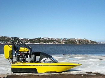
These two communities can only be reached by sea or by air. A special boat called a barge carries goods across the river. A hovercraft takes people across. A new barge was expected to arrive in 2020. A free passenger ferry takes about five minutes to cross the 0.9-kilometer (0.56-mile) wide river. However, it only runs from April to December. When the river freezes in winter, people can cross it by snowmobile using an ice bridge called the "Route Blanche."
What's in a Name?
Long ago, Louis Jolliet (1645–1700) and Jean-Baptiste-Louis Franquelin (1650–1712) called this river "Pegouasiou" or "Pegouachiou." This name meant "deceptive river." It was likely given by the local Indigenous people. They probably called it that because it was shallow and had sandbars at its mouth that could shift.
The name Saint-Augustin was given to the river in the 1700s. Later, the village on its east bank also took this name. The name might be a tribute to Augustin d'Hippone, a religious leader. It could also be named after Augustin le Gardeur de Courtemanche (1663–1717). He was the first person to be granted land in this area.
The River's Basin
The Saint-Augustin River basin is the entire area of land that drains into the river. It covers a huge area of 9,892 square kilometers (3,819 square miles). This basin is located between the Kécarpoui River basin to the west and the Coxipi River basin to the east.
About 40.4% of this watershed is in Labrador. The part in Quebec is mostly in the wild, undeveloped area of Petit-Mécatina. A smaller part is in the municipality of Saint-Augustin. The Pakuashipi Innu community is also located within this river basin.
River Flow and Elevation
The Saint-Augustin River is considered a large river system, with a Strahler number of 7. This number helps describe how many smaller streams flow into it. The main river channel starts high up, at an elevation of 570 meters (1,870 feet). The highest point in the entire watershed is 592 meters (1,942 feet). The average height of the land in the basin is 342 meters (1,122 feet).
The river drops about 460 meters (1,509 feet) in the Labrador section. After that, it drops only about 100 meters (328 feet) over its last 120 kilometers (75 miles). From 1967 to 1982, scientists measured the river's flow. The average amount of water flowing each year ranged from 146 to 207 cubic meters per second (5,156 to 7,310 cubic feet per second). In winter, the flow was as low as 10.8 cubic meters per second (381 cubic feet per second). In May or June, during peak flow, it could reach 2,040 cubic meters per second (72,040 cubic feet per second).
Nature and Wildlife
The Saint-Augustin River is part of a special natural area in Quebec. This area is known for its spruce trees and moss. Most of the land in the river's watershed is covered by forest (74.3%). Other parts have non-forest plants (12.9%), bare ground (3.1%), wetlands (1.3%), and water (8%).
The average daily temperature here is between 0 and 1.2 degrees Celsius (32 and 34.2 degrees Fahrenheit). In January, it can be very cold, from -16.5 to -12.8 degrees Celsius (2.3 to 8.9 degrees Fahrenheit). In July, it's warmer, from 13.9 to 15.2 degrees Celsius (57 to 59.4 degrees Fahrenheit). The area gets a good amount of rain and snow each year, between 1,005.4 and 1,122.4 millimeters (39.6 to 44.2 inches).
Animals of the River
From the mouth of the river, you can see many different kinds of sea birds. You might also spot seals and whales. The St. Augustine Migratory Bird Sanctuary is a protected area nearby. Many birds come here to nest, including:
- Seagulls
- Terns
- Ring-billed gulls
- Herring gulls
- Penguins (though likely referring to auks or murres, which are sometimes mistaken for penguins)
- Black guillemots
- Common eiders
Fishing for Salmon
The Saint-Augustin River is well-known as a place for Atlantic salmon (Salmo salar). These fish are a popular target for anglers.
A company called Pourvoirie Kecarpoui organizes fishing and camping trips in the area. These trips often include fishing on the Saint-Augustin River. They also visit other nearby rivers like the Véco, Kécarpoui, Coxipi, Chécatica, and Napetipi rivers.
 | John T. Biggers |
 | Thomas Blackshear |
 | Mark Bradford |
 | Beverly Buchanan |


