
Saint-Flour, Cantal facts for kids
Quick facts for kids
Saint-Flour
|
||
|---|---|---|

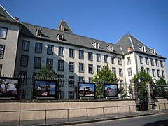
Saint-Flour - the lower town
|
||
|
||

Saint-Flour
Location in France

Saint-Flour
Location in Auvergne-Rhône-Alpes
|
||
| Country | France | |
| Region | Auvergne-Rhône-Alpes | |
| Department | Cantal | |
| Arrondissement | Saint-Flour | |
| Canton | Capital of 2 cantons | |
| Intercommunality | Saint-Flour Communauté | |
| Area
1
|
27.14 km2 (10.48 sq mi) | |
| Population
(2014)
|
6,643 | |
| • Density | 244.77/km2 (633.95/sq mi) | |
| Demonym(s) | Sanflorain | |
| Time zone | UTC+01:00 (CET) | |
| • Summer (DST) | UTC+02:00 (CEST) | |
| INSEE/Postal code |
15187 /15100
|
|
| Elevation | 757–1,040 m (2,484–3,412 ft) (avg. 783 m or 2,569 ft) |
|
| Website | www.saint-flour.fr | |
| 1 French Land Register data, which excludes lakes, ponds, glaciers > 1 km2 (0.386 sq mi or 247 acres) and river estuaries. | ||
.svg)
Saint-Flour (pronounced San Flor) is a town in south central France. It is located in the Auvergne-Rhône-Alpes region. This town is also a "subprefecture" of the Cantal area. A subprefecture is like a smaller administrative center. Saint-Flour is also the main town of its own "arrondissement," which is a type of district in France.
Contents
History of Saint-Flour
Saint-Flour has a long and interesting past. It was once the main town of an old region called Haute-Auvergne. This name means "Upper Auvergne." It was one of the two main parts of the larger Auvergne area.
Becoming a Capital City
In 1790, a new area called the Cantal department was created. At first, Saint-Flour shared the role of being the capital city with another town called Aurillac. They took turns being the main city.
Later, in 1794, Saint-Flour became the only capital of the Cantal department. But this did not last long. In 1795, the capital was moved back to Aurillac. Since then, Saint-Flour has been a subprefecture. This means it is still an important administrative center, but not the main capital.
Geography and Location
Saint-Flour is found in the eastern part of the Cantal department. The town is split into two main sections.
The Upper and Lower Towns
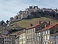
- The upper part of the town is called Ville haute in French. It sits on a high, rocky hill. This hill was formed by a volcanic "dyke," which is like a wall of hardened lava.
- The lower part of the town is called Ville basse. This section is built along the sides of the Ander river. The Ander river flows into the larger Truyère river.
The area of Saint-Flour is about 27.14 square kilometers (10.48 square miles). It is surrounded by several other towns. These include Alleuze, Andelat, Coren, Roffiac, Saint-Georges, and Villedieu.

 |
Roffiac | Andelat | Coren | |
| Villedieu | Saint-Georges | |||
| Villedieu | Alleuze | Saint-Georges |
Climate in Saint-Flour
Saint-Flour has a type of weather called an "Oceanic climate." This means it has mild summers. It is classified as a Cfb climate according to the Köppen climate system.
Population of Saint-Flour
The people who live in Saint-Flour are called Sanflorain in French. If you are talking about a woman from Saint-Flour, you would say Sainfloraine.
In 2014, the town had 6,643 people living there. This means that for every square kilometer, there were about 245 people.
How the population of Saint-Flour has changed
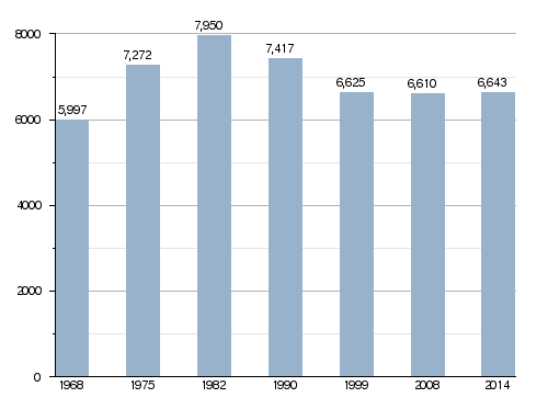
Saint-Flour is the center of its own "urban area." This area includes the town itself and some nearby places. In 2013, this urban area had 6,626 people. It covers about 2,711 square kilometers (1,047 square miles). This urban area is also part of a larger "metropolitan area" of Saint-Flour. This bigger area includes 17 towns and has about 13,024 people. It covers about 326.8 square kilometers (126.2 square miles).
How Saint-Flour is Governed
Saint-Flour is a "subprefecture" of the Cantal department. This means it is an important administrative hub. It is also the main town for the Saint-Flour district.
Administrative Divisions
Saint-Flour is the administrative center for two "cantons." Cantons are like smaller voting and administrative areas.
- Saint-Flour-1: This canton includes 23 smaller towns, plus a part of Saint-Flour. In 2014, about 9,696 people lived here.
- Saint-Flour-2: This canton has 18 smaller towns and another part of Saint-Flour. About 9,171 people lived here in 2014.
Saint-Flour is also part of a group of towns called Saint-Flour Communauté. This group works together on common projects.
Town Partnerships
Saint-Flour has "sister city" relationships with two other towns. This means they are friendly partners and often share cultural events.
 Orléans, France: They have been sister cities since 1986.
 Haselünne, Germany: They became sister cities in 1992.
Gallery
-
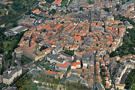
A view of the upper town of Saint-Flour from above
-
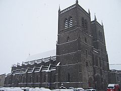
The Saint-Pierre cathedral in Saint-Flour
-
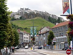
A street view in Saint-Flour
-
Lycée Notre-Dame, a school in Saint-Flour


_Dscn0354-zh.jpg)

Related pages
Images for kids
-
The tourist office building
-
The upper part of the town with its old wall
-

The upper part of the town seen in the mist


See also
 In Spanish: Saint-Flour (Cantal) para niños
