Arrondissement of Saint-Flour facts for kids
Quick facts for kids
Arrondissement of Saint-Flour
|
|
|---|---|

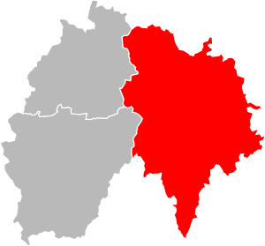
Location of Saint-Flour in Cantal
|
|
| Country | France |
| Region | Auvergne-Rhône-Alpes |
| Department | Cantal |
| Communes | 106 |
| Prefecture | Saint-Flour |
| INSEE code | 153 |
| Area | |
| • Total | 2,511 km2 (970 sq mi) |
| Population
(2014)
|
|
| • Total | 38,079 |
| • Density | 15.165/km2 (39.277/sq mi) |
The arrondissement of Saint-Flour is like a special administrative area in France. Think of it as a district within a larger region. It's part of the Cantal département (which is like a county) in the Auvergne-Rhône-Alpes region (a larger area, similar to a state). The main city, or capital, of this arrondissement is Saint-Flour.
Contents
History of Saint-Flour Arrondissement
The "arrondissements" were created in France way back in 1800. Saint-Flour was one of the first ones to be set up in the Cantal department.
Geography of Saint-Flour
The Saint-Flour arrondissement is the most eastern part of the Cantal department. It covers a large area of about 2,511 square kilometers (970 square miles). This makes it the biggest arrondissement in the department.
Around 38,079 people live here. This means the population density is about 15.2 people per square kilometer.
The arrondissement shares its borders with several other areas:
- To the north, it borders the Puy-de-Dôme department.
- To the east, it borders the Haute-Loire department.
- To the southeast, it borders the Lozère department.
- Also to the southeast, it borders the Aveyron department.
- To the west, it borders the Aurillac and Mauriac arrondissements.
How Saint-Flour is Organized
The arrondissement of Saint-Flour is made up of smaller parts called "cantons" and "communes."
Cantons in Saint-Flour
Cantons are like electoral districts. They were reorganized in France, so sometimes a canton might have small towns (called "communes") that belong to different arrondissements.
In the Saint-Flour arrondissement, there is one canton where not all its communes are within this arrondissement. This is the Canton of Riom-ès-Montagnes.
Here's a quick look at how some cantons are divided:
| INSEE Code |
Canton | Aurillac | Mauriac | Saint-Flour | Total |
|---|---|---|---|---|---|
| 1507 | Murat | 27 | 27 | ||
| 1509 | Neuvéglise | 28 | 28 | ||
| 1510 | Riom-ès-Montagnes | 14 | 9 | 23 | |
| 1511 | Saint-Flour-1 | 23 + part of Saint-Flour | 23 + part of Saint-Flour | ||
| 1512 | Saint-Flour-2 | 18 + part of Saint-Flour | 18 + part of Saint-Flour |
Communes in Saint-Flour
A "commune" is the smallest administrative division in France, similar to a town or a local council area. The Saint-Flour arrondissement has 106 communes. Each commune has a special INSEE code.
- Albepierre-Bredons (15025)
- Allanche (15001)
- Alleuze (15002)
- Andelat (15004)
- Anglards-de-Saint-Flour (15005)
- Anterrieux (15007)
- Auriac-l'Église (15013)
- Bonnac (15022)
- Brezons (15026)
- Celles (15031)
- Celoux (15032)
- Cézens (15033)
- Chaliers (15034)
- Chalinargues (15035)
- Chanterelle (15040)
- La Chapelle-d'Alagnon (15041)
- La Chapelle-Laurent (15042)
- Charmensac (15043)
- Chastel-sur-Murat (15044)
- Chaudes-Aigues (15045)
- Chavagnac (15047)
- Chazelles (15048)
- Cheylade (15049)
- Le Claux (15050)
- Clavières (15051)
- Coltines (15053)
- Condat (15054)
- Coren (15055)
- Cussac (15059)
- Deux-Verges (15060)
- Dienne (15061)
- Espinasse (15065)
- Ferrières-Saint-Mary (15069)
- Fridefont (15073)
- Gourdièges (15077)
- Jabrun (15078)
- Joursac (15080)
- Lacapelle-Barrès (15086)
- Landeyrat (15091)
- Lastic (15097)
- Laurie (15098)
- Lavastrie (15099)
- Laveissenet (15100)
- Laveissière (15101)
- Lavigerie (15102)
- Leyvaux (15105)
- Lieutadès (15106)
- Lorcières (15107)
- Lugarde (15110)
- Malbo (15112)
- Marcenat (15114)
- Marchastel (15116)
- Massiac (15119)
- Maurines (15121)
- Mentières (15125)
- Molèdes (15126)
- Molompize (15127)
- Montboudif (15129)
- Montchamp (15130)
- Montgreleix (15132)
- Murat (15138)
- Narnhac (15139)
- Neussargues-Moissac (15141)
- Neuvéglise (15142)
- Oradour (15145)
- Paulhac (15148)
- Paulhenc (15149)
- Peyrusse (15151)
- Pierrefort (15152)
- Pradiers (15155)
- Rageade (15158)
- Rézentières (15161)
- Roffiac (15164)
- Ruynes-en-Margeride (15168)
- Saint-Amandin (15170)
- Saint-Bonnet-de-Condat (15173)
- Sainte-Anastasie (15171)
- Sainte-Marie (15198)
- Saint-Flour (15187)
- Saint-Georges (15188)
- Saint-Martial (15199)
- Saint-Martin-sous-Vigouroux (15201)
- Saint-Mary-le-Plain (15203)
- Saint-Poncy (15207)
- Saint-Rémy-de-Chaudes-Aigues (15209)
- Saint-Saturnin (15213)
- Saint-Urcize (15216)
- Ségur-les-Villas (15225)
- Sériers (15227)
- Soulages (15229)
- Talizat (15231)
- Tanavelle (15232)
- Les Ternes (15235)
- Tiviers (15237)
- La Trinitat (15241)
- Ussel (15244)
- Vabres (15245)
- Val d'Arcomie (15108)
- Valjouze (15247)
- Valuéjols (15248)
- Védrines-Saint-Loup (15251)
- Vernols (15253)
- Vèze (15256)
- Vieillespesse (15259)
- Villedieu (15262)
- Virargues (15263)
Here are the communes with the most people living in them:
| INSEE code |
Commune | Population (2014) |
Canton | Intercommunality |
|---|---|---|---|---|
| 15187 | Saint-Flour | 6,643 | Saint-Flour-1 and Saint-Flour-2 | Pays de Saint-Flour Margeride |
| 15138 | Murat | 1,880 | Murat | Pays de Murat |
| 15119 | Massiac | 1,735 | Saint-Flour-1 | Pays de Massiac |
| 15188 | Saint-Georges | 1,138 | Neuvéglise | Pays de Saint-Flour Margeride |
| 15142 | Neuvéglise | 1,104 | Neuvéglise | Pays de Pierrefort-Neuvéglise |
| 15054 | Condat | 1,031 | Riom-ès-Montagnes | Cézallier |
| 15108 | Val d'Arcomie | 1,005 | Neuvéglise | Pays de Saint-Flour Margeride |
| 15141 | Neussargues-Moissac | 1,004 | Murat | Pays de Murat |
Related pages
- Arrondissements of the Cantal department
- Communes of the Cantal department
- List of arrondissements of France
See also
 In Spanish: Distrito de Saint-Flour para niños
 | Georgia Louise Harris Brown |
 | Julian Abele |
 | Norma Merrick Sklarek |
 | William Sidney Pittman |

