Saint-Léger, Belgium facts for kids
Quick facts for kids
Saint-Léger
Sint-Ldjir-e-Gåme (Walloon)
|
|||
|---|---|---|---|

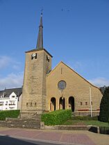
The church
|
|||
|
|||
| Country | Belgium | ||
| Community | French Community | ||
| Region | Wallonia | ||
| Province | Luxembourg | ||
| Arrondissement | Virton | ||
| Area | |||
| • Total | 35.86 km2 (13.85 sq mi) | ||
| Population
(2018-01-01)Lua error in Module:Wd at line 1575: attempt to index field 'wikibase' (a nil value).
|
|||
| • Total | Lua error in Module:Wd at line 1,575: attempt to index field 'wikibase' (a nil value). | ||
| Postal codes |
6747
|
||
| Area codes | 063 | ||
| Website | saint-leger.be | ||
Saint-Léger (pronounced 'san leh-zhay') is a small town in Belgium. It's part of Wallonia, which is the French-speaking region of Belgium. You can find Saint-Léger in the province of Luxembourg. It's a municipality, which means it's like a local government area with its own towns and villages.
As of January 1, 2022, about 3,735 people lived in Saint-Léger. The area of the municipality is about 35.86 square kilometers (around 13.8 square miles). This means there are about 104 people living in each square kilometer.
The municipality of Saint-Léger includes three main areas: Châtillon, Meix-le-Tige, and Saint-Léger itself. There's also a local store called a 'spar' near the town center.
Contents
Getting Around Saint-Léger
Saint-Léger doesn't have any big highways going directly through it. The closest highway is the E25/E411, which connects Brussels and Liège to Luxembourg. You can get on this highway at exit 31 in nearby Arlon.
Main Roads in Saint-Léger
One important national road, the N82, passes through Saint-Léger. It goes from Virton to Arlon, which is the capital city of the province. All N-roads in this area are looked after by the Walloon government.
- N82: Connects Virton to Saint-Léger, then to Châtillon, and finally to Arlon.
- N813: Links Aubange to Meix-le-Teige, then to Châtillon, and ends in Étalle.
Bus Services
The Walloon transport authority, called TEC, provides bus services in Saint-Léger. Here are some of the bus lines that serve the area:
- 19/191: Travels from Virton through Saint-Léger and Châtillon to Arlon.
- 199: Goes from Saint-Mard, through Virton, Saint-Léger, and Châtillon to Arlon.
- 20/201: Connects Châtillon to Meix-le-Teige, Rachecourt, and Arlon.
- 391: Links Saint-Léger to Ruette and Virton.
- 731: Travels from Saint-Léger through Châtillon and Meix-le-Teige to Athus.
Train and Air Travel
There are no train lines that go through Saint-Léger. The closest train station is in Virton, which is about 11.5 kilometers (7 miles) away to the southwest. If you need to fly, the nearest airport with flights is Luxembourg Airport, located about 40.5 kilometers (25 miles) to the east.
See also
 In Spanish: Saint-Léger (Gaume) para niños


