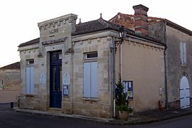
Saint-Laurent-du-Plan facts for kids
Quick facts for kids
Saint-Laurent-du-Plan
|
|
|---|---|
 |
|
| Country | France |
| Region | Nouvelle-Aquitaine |
| Department | Gironde |
| Arrondissement | Langon |
| Canton | L'Entre-Deux-Mers |
| Intercommunality | Coteaux Macariens |
| Area
1
|
2.39 km2 (0.92 sq mi) |
| Population
(Jan. 2021)
|
Lua error in Module:Wd at line 1,575: attempt to index field 'wikibase' (a nil value). |
| Time zone | UTC+01:00 (CET) |
| • Summer (DST) | UTC+02:00 (CEST) |
| INSEE/Postal code |
33428 /33190
|
| Elevation | 19–82 m (62–269 ft) (avg. 53 m or 174 ft) |
| 1 French Land Register data, which excludes lakes, ponds, glaciers > 1 km2 (0.386 sq mi or 247 acres) and river estuaries. | |
Saint-Laurent-du-Plan is a small and charming village, also known as a commune, located in the southwest of France. It is part of the Aquitaine region and can be found in the Gironde department. This area is known for its beautiful landscapes and rich history.
Contents
Discovering Saint-Laurent-du-Plan
Saint-Laurent-du-Plan is a quiet place in the French countryside. It offers a glimpse into traditional French village life. The village is part of a larger administrative area.
What is a Commune?
In France, a commune is the smallest unit of local government. Think of it like a town or a village. Each commune has its own mayor and a local council. They manage things like local services and public spaces. Saint-Laurent-du-Plan is one of many thousands of communes across France.
Where is Saint-Laurent-du-Plan Located?
Saint-Laurent-du-Plan is situated in the Gironde department. This department is part of the Aquitaine region. The region of Aquitaine is in the southwest of France. It is famous for its vineyards and the city of Bordeaux. The village is also close to the Garonne River.
Gironde Department Details
The Gironde department is the largest department in mainland France. It is named after the Gironde estuary. This area is well-known for its wine production. Many famous vineyards are found here. The department offers a mix of coastal areas, forests, and rolling hills.
Aquitaine Region Overview
The Aquitaine region is one of the largest regions in France. It stretches from the Atlantic coast to the Pyrenees mountains. It has a diverse landscape. The region is popular for tourism. It offers beaches, historical sites, and delicious food.
People and Governance
The people who live in Saint-Laurent-du-Plan make up its community. The village is managed by local leaders. These leaders work to improve life for everyone in the commune.
Population of the Commune
Saint-Laurent-du-Plan is a small commune in terms of population. The number of people living there is counted regularly. This helps the local government plan for services. The population figures show how the village is growing or changing over time.
The Mayor of Saint-Laurent-du-Plan
Like all French communes, Saint-Laurent-du-Plan has a mayor. The mayor is the head of the local government. They are elected by the people living in the commune. The mayor helps manage daily life in the village. This includes things like public safety and local events.
Role of the Mayor
The mayor's job is very important. They represent the commune and its people. They also oversee the local budget. The mayor works with the municipal council. Together, they make decisions for the community. This ensures the village runs smoothly.
Geography and Landscape
The land around Saint-Laurent-du-Plan has unique features. These features include its elevation and total area. They shape the environment of the village.
Elevation and Area
Saint-Laurent-du-Plan is located at an average elevation of 53 meters (about 174 feet) above sea level. The lowest point is 19 meters (about 62 feet). The highest point reaches 82 meters (about 269 feet). The total area of the commune is 2.39 square kilometers (about 0.92 square miles). This makes it a relatively small village.
See also
 In Spanish: Saint-Laurent-du-Plan para niños


