Salamander Bay facts for kids
Quick facts for kids Salamander BayNew South Wales |
|||||||||||||||
|---|---|---|---|---|---|---|---|---|---|---|---|---|---|---|---|

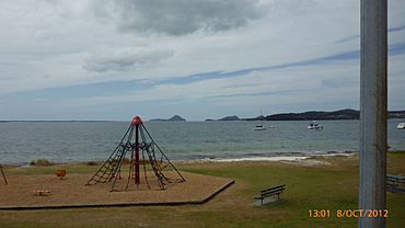
View from Salamander Bay east towards the mouth of Port Stephens approximately 12 km (7.5 mi) away.
|
|||||||||||||||
| Population | 4,991 (2021 census) | ||||||||||||||
| • Density | 587.18/km2 (1,520.8/sq mi) | ||||||||||||||
| Postcode(s) | 2317 | ||||||||||||||
| Elevation | 4.5 m (15 ft) | ||||||||||||||
| Area | 8.5 km2 (3.3 sq mi) | ||||||||||||||
| Time zone | AEST (UTC+10) | ||||||||||||||
| • Summer (DST) | AEDT (UTC+11) | ||||||||||||||
| Location |
|
||||||||||||||
| LGA(s) | Port Stephens Council | ||||||||||||||
| Region | Hunter | ||||||||||||||
| County | Gloucester | ||||||||||||||
| Parish | Tomaree | ||||||||||||||
| State electorate(s) | Port Stephens | ||||||||||||||
| Federal Division(s) | Paterson | ||||||||||||||
|
|||||||||||||||
|
|||||||||||||||
Salamander Bay is a suburb in the Port Stephens Council area of New South Wales, Australia. It is part of the Hunter Region. The land around Port Stephens has always belonged to the Worimi people. They are the traditional owners of this area.
Salamander Bay gets its name from the nearby shallow bay. This bay was named after a ship called Salamander. This ship was a convict ship from the Third Fleet that arrived in Australia. In 1791, it was the first European ship to enter Port Stephens. Today, Salamander Bay is mostly a place where people live. It also has a large shopping centre.
About Salamander Bay
Salamander Bay is a growing community. In 2021, about 4,991 people lived there. It's a great place for families. The suburb has important schools and training centres.
Education and Learning
Salamander Bay is home to several educational places:
- Tomaree High School: This is a high school for older students.
- A TAFE facility: TAFE offers practical training for jobs.
- St Phillips Christian College (Port Stephens Campus): This is a private school.
 | Kyle Baker |
 | Joseph Yoakum |
 | Laura Wheeler Waring |
 | Henry Ossawa Tanner |


