
Salento, Quindío facts for kids
Quick facts for kids
Salento
|
|||
|---|---|---|---|
|
Municipality and town
|
|||
 |
|||
|
|||
| Nickname(s):
"El Padre del Quindío" ("The Father of Quindío")
|
|||

Location map of the municipality and town of Salento in the Department of Quindío.
|
|||
| Country | |||
| Department | Quindío | ||
| Founded | 5 January 1842 | ||
| Named for | Salento, Italy | ||
| Area | |||
| • Municipality and town | 377.67 km2 (145.82 sq mi) | ||
| • Urban | 0.55 km2 (0.21 sq mi) | ||
| Elevation | 1,895 m (6,217 ft) | ||
| Population
(2023)
|
|||
| • Municipality and town | 9,748 | ||
| Time zone | UTC-5 (GMT-5) | ||
| Website | http://www.salento-quindio.gov.co | ||
.svg)

Salento is a charming town and municipality in the northeast of the Quindío department in Colombia. It covers an area of about 377.67 square kilometers. Salento was the very first modern settlement and the first municipality founded in the Quindío region.
The town of Salento is located 24 kilometers northeast of Armenia, the capital city of the department. In 2023, about 9,748 people lived in Salento. This area is famous for its many tourist spots, especially the beautiful Cocora Valley. Here, you can see amazing natural landscapes, like the colorful Barranquero bird, and enjoy peaceful walks.
Long ago, the main road connecting important cities like Popayán and Cali to Bogotá passed through Salento. When this road was changed, Salento became a bit isolated. This actually helped the town keep its old-fashioned colonial buildings and a calm, relaxed way of life. Because of this, Salento and the nearby Cocora Valley are now some of Colombia's most popular places to visit. In 2011, the historic center of Salento was recognized by UNESCO as part of the "Coffee Cultural Landscape" World Heritage List.
Contents
History of Salento
In the old colonial times, a major road from Popayán to Bogotá went over the Quindío Pass, also known as "La Línea". This road passed right where Salento is today. In 1830, Simón Bolívar, a very important leader, traveled this route. He saw how bad the road was and ordered it to be improved because it was so important for travel and trade.
However, the town of Salento itself wasn't officially started until January 5, 1842. This happened after a conflict called the Guerra de los Supremos. People who were taken prisoner during this war were sent from places like Panamá, Antioquia, and Cauca to fix and maintain the road. After they finished their work, they were given land in the area.
The place where these prisoners lived was called Barcinales, which is the same spot where Salento stands now. But the main group of settlers first lived in a valley called Boquía. This was where the Boquía stream meets the Quindío river. The families of the prisoners came and built their homes in Boquía. They also started farms further up in the Cocora Valley.
Around 1854, a big flood from the Quindío river destroyed the settlement of Boquía. The people who survived moved and rebuilt their homes in Barcinales. They decided to keep the name Boquía for their new settlement. The original flooded spot in the valley then became known as Pueblo Viejo, meaning "Old Town."
In 1865, the new Boquía was officially made a municipality. Its name was changed again to Villa de Nueva Salento. The name Boquía went back to refer to the original settlement in the valley. The new name, Salento, was chosen to honor a region in southern Italy.
Geography of Salento
The municipality of Salento is located in the northeastern part of the Quindío department. It shares borders with other towns like Filandia and Circasia to the west. To the southwest, it borders Armenia and Calarcá. To the east, it touches the Tolima department, and to the north, the Risaralda department.
Salento's land is very diverse. It goes from fertile valleys in the west, which are about 1300 meters high, all the way up to the snow-capped peak of the Nevado del Quindío. This mountain is 4750 meters high and is the highest point in the Quindío department.
The town of Salento itself sits on a flat area above the Quindío river valley. The part of the river valley from Salento up to where the river starts is known as the beautiful Cocora valley. The town is about 1895 meters above sea level. It has steep drops to the valley floor on its northern and western sides.
Climate in Salento
Because Salento is high up and close to the tall mountains of the Central Cordillera, it has a subtropical highland climate. This means it's usually cool and pleasant. The average temperature in the town throughout the year is about 17 degrees Celsius (63 degrees Fahrenheit).
Fun Things to Do in Salento
Salento is one of Colombia's most popular places for tourists. People love it for its peaceful atmosphere, especially during the week. On weekends and holidays, it gets busy with visitors. The town also has amazing scenery and it's easy to get to the Cocora Valley.
One of the best things about Salento is that it has kept many of its original bahareque buildings. This is a special style of architecture common in the eje cafetero region. You can see many of these unique buildings on Carrera 6, also known as Calle Real (which means "Royal Road"). This road goes northeast from the town square to a viewpoint called the Alto de la Cruz. Calle Real is the main street in Salento, full of shops selling local handmade crafts.
To reach the Alto de la Cruz viewpoint from the end of Calle Real, you can climb 250 steps. Along the way, there are fourteen Stations of the Cross marked at different spots. From the top of the viewpoint, you get amazing views of the Cocora Valley and many mountains in the Los Nevados National Natural Park.
The restaurants in Salento, especially those in the town square, are famous for their fresh trout. This fish is raised locally further up the Cocora Valley. It's often cooked in different sauces and served on a large patacon, which is a big, fried green plantain.
Salento is also the starting point for trips into the Cocora Valley and hikes in the Los Nevados National Natural Park. You can find jeep taxis in the town square that will take you 11 kilometers up the valley to a small settlement called "Cocora." From there, you can explore the valley on foot or even on horseback using the many trails.
The town's big festival happens every year during the first week of January. This is to celebrate the anniversary of the town's founding, which is on January 5th.
-
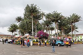
Plaza de Bolívar, the main square
-
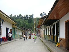
Calle Real, a famous street in Salento
-
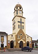
The Church of Nuestra Señora del Carmen
-
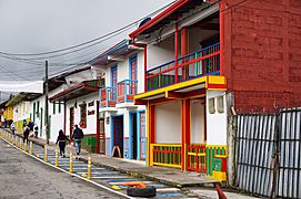
A colorful street in Salento
-
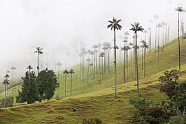
The beautiful Cocora Valley


Economy of Salento
Tourism is the most important part of Salento's economy, especially within the town itself. However, outside the main town area, farming and agriculture are still very important. People in the region raise dairy cows for milk and produce coffee and flowers, among other crops.
See also
 In Spanish: Salento (Quindío) para niños
