Salto Arriba facts for kids
Quick facts for kids
Salto Arriba
|
|
|---|---|
|
Barrio
|
|

Salto Arriba
|
|

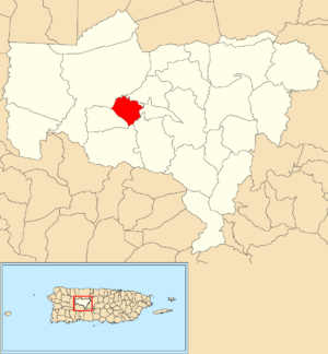
Location of Salto Arriba within the municipality of Utuado shown in red
|
|
| Commonwealth | |
| Municipality | |
| Area | |
| • Total | 1.59 sq mi (4.1 km2) |
| • Land | 1.59 sq mi (4.1 km2) |
| • Water | 0 sq mi (0 km2) |
| Elevation | 702 ft (214 m) |
| Population
(2010)
|
|
| • Total | 617 |
| • Density | 388.1/sq mi (149.8/km2) |
| Source: 2010 Census | |
| Time zone | UTC−4 (AST) |
| ZIP Codes |
00641, 00611
|
| Area code(s) | 787/939 |
Salto Arriba is a small community, also known as a barrio, located in the town of Utuado, Puerto Rico. In 2010, about 617 people lived there.
Where is Salto Arriba?
Salto Arriba is found in the middle part of Utuado, Puerto Rico. It sits about 702 feet (214 meters) above sea level. This area is about 1.59 square miles (4.12 square kilometers) big.
A Look at Salto Arriba's Past
Puerto Rico used to belong to Spain. After the Spanish–American War in 1898, Spain gave Puerto Rico to the United States. It then became a territory of the U.S.
In 1899, the United States government counted the people living in Puerto Rico. They found that 855 people lived in Salto Arriba at that time.
| Historical population | |||
|---|---|---|---|
| Census | Pop. | %± | |
| 1900 | 855 | — | |
| 1980 | 435 | — | |
| 1990 | 368 | −15.4% | |
| 2000 | 442 | 20.1% | |
| 2010 | 617 | 39.6% | |
| U.S. Decennial Census 1899 (shown as 1900) 1910-1930 1930-1950 1980-2000 2010 |
|||
The Bridge Over Río Grande
There is a bridge in Salto Arriba that crosses the Río Grande river. It is part of PR-123. This bridge can be damaged when there are very heavy rains.
For example, a temporary bridge was washed away by floods from Hurricane Fiona on September 18, 2022. This temporary bridge had been built after Hurricane Maria destroyed the original bridge on September 20, 2017.
See Also
 In Spanish: Salto Arriba para niños
- List of communities in Puerto Rico


