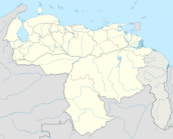
San Carlos de Río Negro facts for kids
Quick facts for kids
San Carlos de Río Negro
|
|
|---|---|
| Country | |
| State | Amazonas State |
| Municipality | Río Negro Municipality |
| Founded | 1759 |
| Elevation | 65 m (213 ft) |
| Population | |
| • Total | 1,200 |
| • Demonym | San Carleño/a |
| Time zone | UTC−4 (VET) |
| Area code(s) | 0248 |
| Climate | Af |
San Carlos de Río Negro is a small town in Venezuela's Amazonas State. About 1200 people live here.
This town is the main center for the Río Negro Municipality. Many Native American people live here. This includes the Yanomami and Baniwa (also called Kurripako) groups. San Carlos de Río Negro is located across the Rio Negro river from San Felipe, a city in Colombia.
Contents
History of San Carlos de Río Negro
How the Town Was Started
The town of San Carlos de Río Negro began in 1759. It was set up as a camp by an expedition led by Captain José Solano y Bote. His group explored the area to find the borders defined by the Treaty of Madrid. This treaty was an agreement between the countries of Portugal and Spain.
José Solano y Bote made his base camp on the banks of the Rio Negro. Only a few of his men survived the long journey up the Orinoco River. Many people on the trip, including the famous Swedish plant expert Pehr Löfling, got sick and died from tropical diseases like yellow fever.
Famous Visitors to the Town
In May 1800, two well-known explorers visited San Carlos de Río Negro. They were Alexander von Humboldt and Aimé Bonpland. This town was the furthest south they traveled during their expedition in the Amazon Basin.
Geography and Nature
Where San Carlos de Río Negro Is Located
The town is just a few kilometers from where the Casiquiare canal begins. This canal is a very important waterway. It connects the Amazon Basin with the Orinoco River. This link joins Venezuela, Colombia, and Brazil. The town is about 65 meters (213 feet) above sea level.
Inside the town, there is a large rock formation called Piedra del Cocuy. It is a great place for climbing. This area is also known for having many different kinds of plants and animals. It is one of the most bio-diverse places on Earth.
How to Travel to San Carlos
Getting to San Carlos de Río Negro can be tricky because it is in a remote area. There is only one small road that connects the town to a small river port. This port is in the nearby town of Solano, which is on the Casiquiare canal. You can also reach the town by small air taxis or private planes.
Climate and Weather
San Carlos de Río Negro has a tropical rainforest climate. This means it is hot and wet all year round. The average temperature is about 26.3 degrees Celsius (79.3 degrees Fahrenheit). The town gets a lot of rain, about 3,430 millimeters (135 inches) each year.
| Climate data for San Carlos de Río Negro | |||||||||||||
|---|---|---|---|---|---|---|---|---|---|---|---|---|---|
| Month | Jan | Feb | Mar | Apr | May | Jun | Jul | Aug | Sep | Oct | Nov | Dec | Year |
| Mean daily maximum °C (°F) | 31.4 (88.5) |
31.6 (88.9) |
31.8 (89.2) |
30.7 (87.3) |
30.2 (86.4) |
29.6 (85.3) |
29.6 (85.3) |
30.7 (87.3) |
31.7 (89.1) |
31.6 (88.9) |
31.7 (89.1) |
31.3 (88.3) |
31.0 (87.8) |
| Daily mean °C (°F) | 26.5 (79.7) |
26.6 (79.9) |
26.8 (80.2) |
26.1 (79.0) |
25.8 (78.4) |
25.7 (78.3) |
25.5 (77.9) |
26.1 (79.0) |
26.6 (79.9) |
26.8 (80.2) |
26.7 (80.1) |
26.5 (79.7) |
26.3 (79.4) |
| Mean daily minimum °C (°F) | 21.6 (70.9) |
21.6 (70.9) |
21.8 (71.2) |
21.6 (70.9) |
21.5 (70.7) |
21.9 (71.4) |
21.4 (70.5) |
21.5 (70.7) |
21.5 (70.7) |
22.0 (71.6) |
21.8 (71.2) |
21.7 (71.1) |
21.7 (71.0) |
| Average rainfall mm (inches) | 215 (8.5) |
198 (7.8) |
276 (10.9) |
313 (12.3) |
398 (15.7) |
394 (15.5) |
360 (14.2) |
310 (12.2) |
270 (10.6) |
249 (9.8) |
220 (8.7) |
227 (8.9) |
3,430 (135.1) |
See also
 In Spanish: San Carlos de Río Negro para niños
 | Emma Amos |
 | Edward Mitchell Bannister |
 | Larry D. Alexander |
 | Ernie Barnes |


