San Jerónimo, Baja Verapaz facts for kids
Quick facts for kids
San Jerónimo
|
|
|---|---|
|
Municipality
|
|

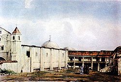
Hacienda and church of the Order of Preachers in San Jerónimco in 1844. Drawing by M. Van Lockhoet.
|
|
| Country | |
| Department | |
| Area | |
| • Municipality | 275 km2 (106 sq mi) |
| Population
(2018 census)
|
|
| • Municipality | 25,459 |
| • Density | 92.58/km2 (239.8/sq mi) |
| • Urban | 10,530 |
| Climate | Aw |
San Jerónimo is a town and a municipality (a type of local government area) in the Baja Verapaz department of Guatemala. It sits 940 meters (about 3,084 feet) above sea level. In 2018, about 25,459 people lived there. The town covers an area of 275 square kilometers (about 106 square miles).
The main language spoken in San Jerónimo is Spanish. Every year, from September 27 to 30, the town celebrates its main festival. This fair honors the town's patron saint, Saint Jerome.
Contents
History of San Jerónimo
After the Spanish took control of the Verapaz region, the Hacienda de San Jerónimo was created. A "hacienda" was a large estate or farm. This one was managed by Dominican priests. It is believed that some of the first priests to arrive in the San Jerónimo Valley were Friars Luis Cancer, Bartolomé de las Casas, Luis de Ladrada, and Pedro Angulo.

Friar Luis Cancer ordered the building of the first church in 1537. The Hacienda itself was founded between 1540 and 1550. In 1601, the first sugar plantation in Central America was started here by Rafael Lujan. This hacienda became very important to the Spanish Kingdom. It produced sugar, a red dye called cochineal, grapes, wine, and strong drinks. However, the friars preferred growing grapes over sugar cane.
Friar Francisco Callejos, who managed the Hacienda, built a Roman-style aqueduct. An aqueduct is a channel used to carry water. This one brought water to the people. You can still see the ruins of this aqueduct today. The symbol of the Dominican order is carved into it. It's located in San Jerónimo town, especially visible on the road to the San Lorenzo farm.
British Influence in San Jerónimo
In the early 1830s, travelers could see the dry valley of Salamá from the southern mountains. The road was good, but getting down to the creek was difficult. Along the creek, there were many trees, offering a place to rest. Salamá was a small town with a clear creek and a central square.
Near the town was an old convent. This convent was considered the largest and most valuable property in the country. In 1829, it was sold to Marshall Bennett. He was a business agent for Francisco Morazán, who traded in fine wood. Bennett named it "Hacienda de San Jerónimo."
Soon, the hacienda had many sugar and coffee farms. This was possible because Bennett improved the old water system. He replaced the friars' grapevines with sugar cane. The wine was replaced by a rum called "Puro de San Gerónimo," which became famous.
The local people and Black settlers in Salamá were used to the strict rules of the monastery. Bennett used this to his advantage, and his first years were very profitable. But later, there were disagreements among his family. Also, with the friars gone, problems grew between the hacienda owners and the townspeople.
Hacienda de San Jerónimo Challenges
By 1890, the problems at the hacienda became very serious. Local people and mestizos (people of mixed heritage) had moved onto the edges of the hacienda. They were stealing wood and farm products. They also set fields on fire and damaged the water system.
Eventually, an angry crowd set the sugar mill on fire and attacked the hacienda manager. When things got this bad, the owners contacted the British Ambassador. The government knew that some of its own officials had supported these attacks. After talks, the government agreed to remove the people who had invaded the land. They also agreed to pay the hacienda owners about fourteen thousand Guatemalan pesos.
Additionally, it was agreed to sell a part of the hacienda. This land would be used to create a new town. The old church would also be given to this new town.

Things to See in San Jerónimo
The main place to visit in San Jerónimo is "El Trapiche" Museum. This museum shows the history of the San Jerónimo area and the Hacienda.
You can also find other old sites in places like El Portón, Laguna, Los Mangales, Matanzas, Pueblo Viejo, Sibabaj, Xubalbal, Zacualpa, and La Presa. These are important archaeological sites.
Climate and Weather
San Jerónimo has a tropical savanna climate. This type of climate usually has warm temperatures all year and distinct wet and dry seasons.
| Climate data for San Jerónimo, Baja Verapaz (1991–2020) | |||||||||||||
|---|---|---|---|---|---|---|---|---|---|---|---|---|---|
| Month | Jan | Feb | Mar | Apr | May | Jun | Jul | Aug | Sep | Oct | Nov | Dec | Year |
| Record high °C (°F) | 35.0 (95.0) |
36.5 (97.7) |
37.0 (98.6) |
37.7 (99.9) |
37.0 (98.6) |
36.5 (97.7) |
33.2 (91.8) |
34.5 (94.1) |
34.1 (93.4) |
32.4 (90.3) |
33.0 (91.4) |
33.6 (92.5) |
37.7 (99.9) |
| Mean daily maximum °C (°F) | 27.1 (80.8) |
28.8 (83.8) |
30.4 (86.7) |
31.7 (89.1) |
31.2 (88.2) |
29.8 (85.6) |
29.1 (84.4) |
29.6 (85.3) |
29.5 (85.1) |
28.4 (83.1) |
27.1 (80.8) |
27.0 (80.6) |
29.1 (84.4) |
| Daily mean °C (°F) | 21.1 (70.0) |
22.1 (71.8) |
23.0 (73.4) |
24.3 (75.7) |
24.4 (75.9) |
23.7 (74.7) |
23.3 (73.9) |
23.4 (74.1) |
23.4 (74.1) |
22.9 (73.2) |
21.7 (71.1) |
21.0 (69.8) |
22.9 (73.2) |
| Mean daily minimum °C (°F) | 12.6 (54.7) |
13.1 (55.6) |
14.2 (57.6) |
16.1 (61.0) |
17.4 (63.3) |
17.7 (63.9) |
16.7 (62.1) |
16.7 (62.1) |
17.2 (63.0) |
16.3 (61.3) |
14.5 (58.1) |
13.2 (55.8) |
15.5 (59.9) |
| Record low °C (°F) | 1.7 (35.1) |
5.9 (42.6) |
3.5 (38.3) |
7.4 (45.3) |
8.7 (47.7) |
8.9 (48.0) |
2.9 (37.2) |
10.7 (51.3) |
10.6 (51.1) |
7.4 (45.3) |
5.0 (41.0) |
4.6 (40.3) |
1.7 (35.1) |
| Average precipitation mm (inches) | 6.6 (0.26) |
4.3 (0.17) |
16.4 (0.65) |
38.7 (1.52) |
91.8 (3.61) |
189.6 (7.46) |
134.0 (5.28) |
156.7 (6.17) |
186.5 (7.34) |
118.6 (4.67) |
36.4 (1.43) |
12.8 (0.50) |
992.4 (39.07) |
| Average precipitation days (≥ 1.0 mm) | 2.1 | 1.3 | 2.8 | 3.6 | 7.4 | 15.9 | 13.5 | 13.7 | 16.1 | 12.2 | 5.6 | 3.2 | 97.4 |
| Source: NOAA | |||||||||||||
Where is San Jerónimo Located?
San Jerónimo shares its borders with only two other municipalities. These are Salamá in the Baja Verapaz Department and Morazán in the El Progreso Department.
 |
Salamá | Salamá |  |
|
| Salamá | Morazán | |||
| Salamá | Morazán |
See also
 In Spanish: San Jerónimo (Baja Verapaz) para niños
 | Lonnie Johnson |
 | Granville Woods |
 | Lewis Howard Latimer |
 | James West |


