
San Joaquin, California facts for kids
Quick facts for kids
San Joaquin, California
|
||
|---|---|---|
| City of San Joaquin | ||

Main Street in San Joaquin
|
||
|
||

Location in Fresno County and the state of California
|
||

San Joaquin, California
Location in the United States
|
||
| Country | United States | |
| State | California | |
| County | Fresno | |
| Incorporated | February 14, 1920 | |
| Named for | St. Joachim | |
| Government | ||
| • Type | Council–Manager | |
| Area | ||
| • Total | 1.20 sq mi (3.10 km2) | |
| • Land | 1.20 sq mi (3.10 km2) | |
| • Water | 0.00 sq mi (0.00 km2) 0% | |
| Elevation | 174 ft (53 m) | |
| Population
(2020)
|
||
| • Total | 3,701 | |
| • Density | 3,084/sq mi (1,193.9/km2) | |
| Time zone | UTC-8 (PST) | |
| • Summer (DST) | UTC-7 (PDT) | |
| ZIP code |
93660
|
|
| Area code(s) | 559 | |
| FIPS code | 06-67126 | |
| GNIS feature IDs | 277594, 2411789 | |

San Joaquin (Spanish: San Joaquín, meaning "St. Joachim") is a city in Fresno County, California, United States. In 2010, about 4,001 people lived there. This was more than the 3,270 people counted in 2000.
The closest high school is Tranquillity High School in Tranquillity. San Joaquin is located about 11 miles (18 km) southwest of Kerman. The city sits at an elevation of 174 feet (53 meters) above sea level.
Contents
What's in a Name?
San Joaquin got its name from the San Joaquin River. This river is a major waterway in California.
Where is San Joaquin Located?
The United States Census Bureau says that San Joaquin covers a total area of 1.1 square miles (2.8 square kilometers). All of this area is land, with no water.
A Look at San Joaquin's Past
The first post office in San Joaquin opened in 1913. The city officially became an incorporated city in 1920. This means it became a self-governing community.
How Many People Live Here?
| Historical population | |||
|---|---|---|---|
| Census | Pop. | %± | |
| 1930 | 163 | — | |
| 1940 | 240 | 47.2% | |
| 1950 | 632 | 163.3% | |
| 1960 | 879 | 39.1% | |
| 1970 | 1,506 | 71.3% | |
| 1980 | 1,930 | 28.2% | |
| 1990 | 2,311 | 19.7% | |
| 2000 | 3,270 | 41.5% | |
| 2010 | 4,001 | 22.4% | |
| 2019 (est.) | 4,021 | 0.5% | |
| U.S. Decennial Census | |||
Population in 2010
In 2010, San Joaquin had a population of 4,001 people. The city had about 3,485 people per square mile (1,346 per square kilometer).
The population was very diverse. About 49.1% of residents were White. About 0.8% were African American. Native Americans made up 1.3% of the population. Asians were 0.9%, and 44.1% were from other races. About 3.7% of people identified as two or more races. A large part of the population, 95.6%, identified as Hispanic or Latino.
There were 882 households in the city. Many households, 74.8%, had children under 18 living there. The average household had about 4.54 people. The average family size was 4.66 people.
The median age in San Joaquin was 23.6 years old. This means half the people were younger than 23.6, and half were older.
Population in 2000
In 2000, San Joaquin had 3,270 people living in 702 households. The population density was about 3,302 people per square mile (1,275 per square kilometer).
The racial makeup was also diverse. About 35.44% were White. About 0.21% were African American. Native Americans were 1.56%, and Asians were 3.61%. About 53.73% were from other races, and 5.44% were from two or more races. Most of the population, 91.99%, was Hispanic or Latino.
Many households, 67.9%, had children under 18. The average household size was 4.66 people. The average family size was 4.79 people. The median age was 22 years.
Learning and Education
Many people in San Joaquin work in the agriculture industry. This means they work on farms.
According to a writer named David Brooks, only a small number of residents have college degrees. About 2.9% have bachelor's degrees, and 20.6% have high school degrees. These numbers show that education is an important area for growth in San Joaquin.
Images for kids
-
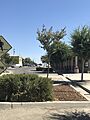
Main Street in San Joaquin
-
Seal of San Joaquin, California
-
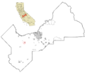
Location in Fresno County and California
See also
 In Spanish: San Joaquín (California) para niños
