
San Juan, Texas facts for kids
Quick facts for kids
San Juan, Texas
|
|
|---|---|

Location of San Juan, Texas
|
|
 |
|
| Country | |
| State | |
| County | Hidalgo |
| Government | |
| • Type | Council-Manager |
| Area | |
| • Total | 11.64 sq mi (30.16 km2) |
| • Land | 11.64 sq mi (30.16 km2) |
| • Water | 0.00 sq mi (0.00 km2) |
| Elevation | 105 ft (32 m) |
| Population
(2020)
|
|
| • Total | 35,294 |
| • Density | 3,032.13/sq mi (1,170.23/km2) |
| Time zone | UTC-6 (Central (CST)) |
| • Summer (DST) | UTC-5 (CDT) |
| ZIP code |
78589
|
| Area code(s) | 956 |
| FIPS code | 48-65516 |
| GNIS feature ID | 1346393 |
San Juan is a city in Hidalgo County, Texas, USA. In 2020, about 35,294 people lived there. This was more than the 33,856 people in 2010. San Juan is part of a larger area called the McAllen–Edinburg–Mission metropolitan area.
The city is famous for the Basilica of the National Shrine of Our Lady of San Juan del Valle. This is one of the biggest churches in South Texas.
Contents
History of San Juan
The community of San Juan was started in 1909. John Closner helped a lot to organize the city.
Geography of San Juan
San Juan is located in the Rio Grande Valley region. To its west is the city of Pharr. To its east is the city of Alamo.
Nearby communities include Lopezville to the northwest. Murillo is to the north, and North Alamo is to the northeast. San Juan is about 5 miles (8 km) east of McAllen. It is 8 miles (13 km) south of Edinburg, which is the county seat. The city is also about 10 miles (16 km) north of the Mexican border. The border crossing is at the Pharr–Reynosa International Bridge over the Rio Grande.
According to the United States Census Bureau, San Juan covers about 11.6 square miles (30.16 square kilometers) of land. There is no water area. The center of San Juan is south of Interstate 2/U.S. Route 83. It is also east of U.S. Route 281.
Population in San Juan
| Historical population | |||
|---|---|---|---|
| Census | Pop. | %± | |
| 1920 | 1,203 | — | |
| 1930 | 1,615 | 34.2% | |
| 1940 | 2,264 | 40.2% | |
| 1950 | 3,413 | 50.8% | |
| 1960 | 4,371 | 28.1% | |
| 1970 | 5,070 | 16.0% | |
| 1980 | 7,608 | 50.1% | |
| 1990 | 10,815 | 42.2% | |
| 2000 | 26,229 | 142.5% | |
| 2010 | 33,856 | 29.1% | |
| 2020 | 35,294 | 4.2% | |
| U.S. Decennial Census | |||
How Many People Live Here?
| Race | Number | Percentage |
|---|---|---|
| White (NH) | 998 | 2.83% |
| Black or African American (NH) | 50 | 0.14% |
| Native American or Alaska Native (NH) | 30 | 0.09% |
| Asian (NH) | 67 | 0.19% |
| Pacific Islander (NH) | 2 | 0.01% |
| Some Other Race (NH) | 57 | 0.16% |
| Mixed/Multi-Racial (NH) | 83 | 0.24% |
| Hispanic or Latino | 34,007 | 96.35% |
| Total | 35,294 |
In 2020, the 2020 United States census counted 35,294 people in San Juan. There were 9,875 households and 8,566 families living in the city.
Education in San Juan
Schools for Kids
Most of San Juan is part of the Pharr-San Juan-Alamo Independent School District. A small part of the city belongs to the Hidalgo Independent School District.
Elementary schools in San Juan include:
- Carman Elementary
- Clover Elementary
- Doedyns Elementary
- Garza-Peña Elementary
- North San Juan Elementary
- Reed-Mock Elementary
- Sorensen Elementary
- Leonel Trevino Elementary
Middle schools in the city are Austin Middle School (opened in 1970) and San Juan Middle School. Pharr-San Juan-Alamo High School is in San Juan and serves most students. A small part of the city goes to Pharr-San Juan-Alamo Memorial High School in Alamo.
The South Texas Independent School District also runs special magnet schools for students in the area.
Public Library
The San Juan Memorial Library serves the city. You can find it at 1010 S. Standard, San Juan, Texas 78589.
Radio Stations
You can listen to these radio stations in San Juan:
- KFRQ 94.5FM
- KKPS 99.5FM
- KNVO 101.1FM
- KVLY 107.9FM
Photo gallery
-
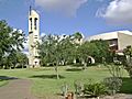
Basilica of the National Shrine of Our Lady of San Juan del Valle
-
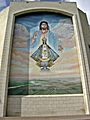
Virgin de San Juan shrine


See also
 In Spanish: San Juan (condado de Hidalgo, Texas) para niños
