
San Tan Mountains Regional Park facts for kids
San Tan Mountains Regional Park is a big park in Maricopa County, Arizona. It covers more than 10,000 acres and protects part of the San Tan Mountains. The park is located south of Queen Creek. It's a great place to explore the desert!
Contents
Exploring San Tan Mountains Regional Park
This amazing park covers over 10,200 acres of the Sonoran Desert. It's about 30 miles southeast of downtown Phoenix. The park is bordered by Higley Basin to the north and Chandler Heights to the northwest. The Gila River Indian Reservation is to the west and south.
The land in the park goes from about 1,400 feet to 2,500 feet high. The highest spot is in the Malpais Hills, at 2,539 feet. You'll find Goldmine Mountain in the north and the Malpais Hills in the south. These mountains rise above the flatter parts of the park.
Weather in the Park
The park has hot summers and mild winters. In July, the average temperature is about 104 degrees Fahrenheit. In January, it's around 65 degrees. The park gets about 9 inches of rain each year. Most of this rain falls between May and October.
Plants and Animals of the Sonoran Desert
The park is home to many different plants, from creosote flats to saguaro forests. You can also find many reptiles, birds, and mammals here. The plants are part of the Sonoran Desertscrub, which is a very green part of the desert.
About 90% of the plants in the park are native to the area. The other 10% are plants that came from other places. Some of the most common plant families include:
- Asteraceae (like Desert Marigold and Brittlebush)
- Poaceae (grasses like Red Brome and Bermuda Grass)
- Fabaceae (like Catclaw acacia and Velvet Mesquite)
- Boraginaceae (like Common fiddleneck)
- Cactaceae (like the famous saguaro, Buckhorn Cholla, and barrel cactus)
Fun Activities in the Park
The park is mostly used for fun outdoor activities like horseback riding and hiking. In 2003, a plan was made to help the park handle more visitors. This plan helps protect historical sites, plants, and animal homes. New areas are being created, and fences are put up to protect sensitive spots. Trails and roads are also being built or fixed up.
There are also many trails for mountain biking. You can even visit an educational area to learn about the lives of the desert tortoise. As of 2018, there were nine hiking trails in the park:
- Little Leaf Trail (0.7 mile)
- Stargazer Trail (0.8 mile)
- Hedgehog Trail (1 mile)
- Moonlight Trail (1.3 miles)
- Gold Mine Trail (2.5 miles) - This trail takes you to the highest point in the park!
- San Tan Trail (6.4 miles)
History of the San Tan Mountains Area
People have lived in this area for a very long time. From about 1100 to 1450 A.D., the Hohokam people lived here. They built rock piles in fields, which shows they were farming plants like agaves, yuccas, and chollas. Before 1975, most of the area was undeveloped. Only a few people prospected for minerals, grazed cattle, or used a stagecoach trail.
Mansel Carter and Marion Kennedy
In 1948, two prospectors named Mansel Carter and Marion Kennedy moved to the area. They first lived in a cave near Goldmine Mountain, then built a small shack. They made a living by mining for copper, silver, turquoise, and gold. Over the years, they used their mining money to claim 55 mining spots. Mansel Carter's family still owns these claims today.
Marion Kennedy passed away in 1960. Mansel Carter, known as the "Old Man of the Mountain," kept mining. He also started carving small figures from wood and cactus skeletons. He died in 1987 at the age of 85.
Creating the Park
The San Tan Mountains Regional Park was created in 1986. It started with about 6,800 acres owned by the United States Bureau of Land Management. In the 1990s, another 3,400 acres owned by Maricopa County were added to the park.
In 2005, a visitor center was built, making it easier for people to access and enjoy the park. The area around the park has farms, desert flats, and small hills. Some low-density housing has also been built nearby.
Images for kids
-
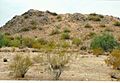
Gold Mountain in San Tan Mountains Regional Park
_Gold_Mountain-1.jpg)
