Sangre de Cristo Ranches, Colorado facts for kids
Quick facts for kids
Sangre de Cristo Ranches, Colorado
|
|
|---|---|

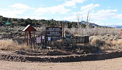
Signs at one of the entrances.
|
|
| Country | |
| State | |
| County | Costilla County |
| Time zone | UTC-7 (MST) |
| • Summer (DST) | UTC-6 (MDT) |
| ZIP code |
81133 (Fort Garland)
|
Sangre de Cristo Ranches is a special kind of community in Colorado, United States. It's called an "unincorporated community." This means it's a place where people live, but it doesn't have its own local government like a city or town. Instead, it's part of a larger area called Costilla County.
This community is located close to a town called Fort Garland. If you send mail to Sangre de Cristo Ranches, it will use the same ZIP code (81133) as Fort Garland.
Contents
Exploring Sangre de Cristo Ranches
Sangre de Cristo Ranches is a private area with lots of open space. It's nestled right in the middle of the beautiful Sangre de Cristo Mountains in Southern Colorado. Imagine living surrounded by mountains!
How to Get There
You can reach this area from Route 160. This road is on the eastern edge of the San Luis Valley. It's about 50 miles (80 km) west of Walsenburg. It's also just 1 mile (1.6 km) east of Fort Garland and 30 miles (48 km) east of Alamosa. All these places are in Costilla County.
The History of the Ranches
A company called Forbes, Inc. started developing this area. They began selling land lots in 1971. They continued selling these lots until around the year 2000.
Land and Lots
There are almost 8,000 different land lots in Sangre de Cristo Ranches. These lots vary in size, from 5 acres to 30 acres (about 2 to 12 hectares). That's a lot of land!
The entire area covers about 56,160 acres (227 square kilometers). A big part of this land, about 4,624 acres (18.7 square kilometers), is set aside as "Common Land." This means it's land that everyone in the community can use and enjoy.
 | Audre Lorde |
 | John Berry Meachum |
 | Ferdinand Lee Barnett |


