Santa Teresa Hills facts for kids
Quick facts for kids Santa Teresa Hills |
|
|---|---|

Coyote Peak
|
|
| Highest point | |
| Elevation | 1,027 ft (313 m) |
| Geography | |
| Country | United States |
| State | California |
| District | Santa Clara County |
| Range coordinates | 37°12′58.800″N 121°48′17.825″W / 37.21633333°N 121.80495139°W |
| Topo map | USGS Santa Teresa Hills |
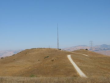
The Santa Teresa Hills are a beautiful range of hills located in Santa Clara County, California. Most of these hills are found right within the city of San Jose. They act like a natural border, separating two neighborhoods: Almaden Valley on the west side and Santa Teresa on the east.
Contents
Exploring the Santa Teresa Hills
The Santa Teresa Hills are a great place to explore nature. They are not as tall as big mountains, but they offer amazing views of the surrounding area. The highest point in these hills reaches about 1,027 feet (313 meters) above sea level.
What Makes These Hills Special?
These hills are part of a larger group called the Santa Cruz Mountains. They are known for their unique plants and animals. Many people enjoy hiking and biking on the trails that wind through the hills.
A Look Back in Time: Rancho San Vicente
Long ago, the Santa Teresa Hills were part of a very large piece of land called Rancho San Vicente. This land was given to a person named José de los Reyes Berryessa a long time ago. These land grants were a common way for the government to give out land in early California.
The History of Ranchos
Ranchos were large farms or ranches. They were very important in California's history, especially during the time when California was part of Mexico. People used these lands for raising cattle and growing crops. The history of Rancho San Vicente is a small part of the bigger story of how California grew and changed.
 | Janet Taylor Pickett |
 | Synthia Saint James |
 | Howardena Pindell |
 | Faith Ringgold |


