
Santa Venetia, California facts for kids
Quick facts for kids
Santa Venetia
|
|
|---|---|

Santa Venetia as seen from Terra Linda
|
|

Location in Marin County and the state of California
|
|

Santa Venetia, California
Location in the United States
|
|
| Country | United States |
| State | California |
| County | Marin |
| Area | |
| • Total | 3.693 sq mi (9.56 km2) |
| • Land | 3.664 sq mi (9.49 km2) |
| • Water | 0.029 sq mi (0.08 km2) 0.79% |
| Elevation | 56 ft (17 m) |
| Population
(2020)
|
|
| • Total | 4,289 |
| • Density | 1,161.39/sq mi (448.41/km2) |
| Time zone | UTC-8 (PST) |
| • Summer (DST) | UTC-7 (PDT) |
| ZIP code |
94903
|
| Area codes | 415/628 |
| FIPS code | 06-70154 |
| GNIS feature ID | 1659603 |
Santa Venetia is a special community in Marin County, California, United States. It is known as a census-designated place (CDP). This means it is a place identified by the U.S. Census Bureau for statistical purposes.
Santa Venetia is located about 1.5 miles (2.4 km) north of downtown San Rafael. It sits at an elevation of 56 feet (17 meters) above sea level. In 2020, the population of Santa Venetia was 4,289 people.
Contents
Geography of Santa Venetia
Santa Venetia is found in the eastern part of Marin County. Its exact location is 37°59′55″N 122°31′31″W / 37.99861°N 122.52528°W.
- To the south and west, it borders the city of San Rafael, which is the county seat.
- To the east, it is next to San Pablo Bay. This bay is the northern part of the San Francisco Bay estuary, where fresh and salt water mix.
- Gallinas Creek forms the northern boundary of the community.
- A large part of the eastern CDP area is taken up by China Camp State Park.
The United States Census Bureau reports that Santa Venetia has a total area of about 3.7 square miles (9.6 square kilometers). Only a small part, about 0.03 square miles (0.08 square kilometers), or 0.79%, is water.
The main road in Santa Venetia is North San Pedro Road. This road passes by the Frank Lloyd Wright-designed Marin County Civic Center. The road continues east through China Camp State Park, runs along the bay through Peacock Gap, and ends in San Rafael. Santa Venetia also has a protected open space for its marshland, as it borders San Pablo Bay.
History of Santa Venetia
Santa Venetia was built on marshland that was filled in during 1914. At that time, a real estate developer named Mabry McMahan had a big idea. He wanted to create a fancy bayside community. He imagined it would be like Venice, Italy, which is called "Venezia" in Italian.
His plan included canals and gondolas, just like in Venice. However, the economy got worse after the First World War, and his project could not be finished. It's interesting to note that there isn't actually a Christian saint named Venice or Venetia, even though the name "Santa" means "saint."
- After the Second World War, Santa Venetia started to grow a lot.
- New suburban neighborhoods, like Gallinas Village, were built on the land that was filled in 1914.
Santa Venetia used to have a local YMCA building. Sadly, it was destroyed by a fire in 1986. Later, a developer bought the land and built new houses there, which were finished in 1987.
During the 1960s and 1970s, teenagers and other residents sometimes playfully called the area "Lower Scabo" and "Upper Scabo."
Today, Santa Venetia is a peaceful neighborhood. Many residents enjoy its close location to China Camp State Park. Homes along the canal often have direct access to the water.
Population and People in Santa Venetia

This section shares information about the people living in Santa Venetia, based on official counts called censuses.
Santa Venetia in 2010
According to the 2010 census, Santa Venetia had a population of 4,292 people. This means there were about 1,166.3 people per square mile (450.3 per square kilometer).
The census also looked at the different backgrounds of the people:
- 77.7% (3,335 people) were White.
- 2.1% (88 people) were African American.
- 0.6% (27 people) were Native American.
- 7.1% (306 people) were Asian.
- 0.4% (16 people) were Pacific Islander.
- 8.2% (350 people) were from other races.
- 4.0% (170 people) were from two or more races.
- Overall, 19.0% (815 people) were of Hispanic or Latino background.
Most people (95.1%) lived in regular homes. A small number lived in group housing (1.5%) or institutions (3.4%).
There were 1,655 households in Santa Venetia.
- 29.0% of these households had children under 18.
- 46.5% were married couples.
- 10.9% had a female head of household with no husband.
- 4.9% had a male head of household with no wife.
- The average household had 2.47 people.
- There were 1,030 families, with an average of 2.97 people per family.
The age of the people living in Santa Venetia varied:
- 18.7% were under 18 years old.
- 5.1% were between 18 and 24.
- 22.4% were between 25 and 44.
- 33.4% were between 45 and 64.
- 20.4% were 65 or older.
- The average age was 47.7 years.
There were 1,706 housing units. Most of these (71.8%) were owned by the people living in them, and 28.2% were rented.
Santa Venetia in 2000

The 2000 census showed that Santa Venetia had 4,298 people. There were 1,646 households and 1,048 families. The population density was about 1,143.0 people per square mile (441.3 per square kilometer).
The racial makeup in 2010 was:
- 68.5% White (not Hispanic).
- 2.0% African American (not Hispanic).
- 0.2% Native American.
- 7.0% Asian.
- 0.3% Pacific Islander.
- 0.3% from other races.
- 2.6% from two or more races.
- 19.0% of people were Hispanic or Latino.
Of the households:
- 25.5% had children under 18.
- 49.0% were married couples.
- 10.6% had a female head of household without a husband.
- The average household size was 2.47 people, and the average family size was 2.91 people.
The age distribution was:
- 18.1% under 18.
- 5.2% from 18 to 24.
- 27.3% from 25 to 44.
- 29.1% from 45 to 64.
- 20.3% were 65 or older.
- The average age was 45 years.
The median household income was $75,600, and the median family income was $77,202. The per person income was $34,732. About 7.3% of the population lived below the poverty line.
Education in Santa Venetia
Children living in Santa Venetia attend schools that are part of the San Rafael Elementary School District and the San Rafael High School District. These two districts are run together as San Rafael City Schools.
- The local school serving the community is Venetia Valley K-8 School. This school teaches students from kindergarten through 8th grade.
- For high school, students can choose to attend either San Rafael High School or Terra Linda High School.
Santa Venetia Neighborhood Association
The Santa Venetia Neighborhood Association (SVNA) is a very active group in the community. It works to keep and improve the quality of life in Santa Venetia.
The SVNA does this by:
- Encouraging friendly social interactions among neighbors.
- Helping information flow easily within the community.
- Protecting the natural beauty of the area.
- Supporting the economic well-being of the community.
The SVNA holds regular meetings for the community. They also organize social events and neighborhood work days. In addition, they publish a newsletter every two months to keep residents informed.
Images for kids
-
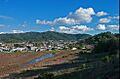
Santa Venetia as seen from Terra Linda
-
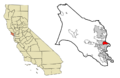
Location in Marin County and the state of California
-
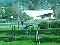
A heron flies by the Marin Post Office in Santa Venetia
-
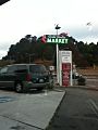
Santa Venetia market in Marin County
See also
 In Spanish: Santa Venetia para niños
