Sarichef Island facts for kids

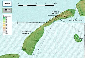
Elevation map
|
|
| Geography | |
|---|---|
| Location | Nome Census Area, Alaska |
| Coordinates | 66°14′41″N 166°6′25″W / 66.24472°N 166.10694°W |
| Length | 7 km (4.3 mi) |
| Highest elevation | 6 m (20 ft) |
| Administration | |
| Demographics | |
| Population | 591 (2006) |
Sarichef Island is a long, narrow island located off the coast of Alaska. It faces the Chukchi Sea, which is part of the Arctic Ocean. This island is found at the entrance of the Shishmaref Inlet. It is part of the Kotzebue-Kobuk Low region. On a clear day, you might even see Russia from the island, as it's only about a hundred miles away!
The highest point on Sarichef Island is a cemetery in the town of Shishmaref. This spot is about 6 meters (20 feet) above sea level. The island is about 7 kilometers (4.3 miles) long.
Sarichef Island: A Shrinking Home
Sarichef Island is home to the town of Shishmaref and the Shishmaref Airport. Sadly, the island is slowly disappearing. This is happening because of something called sea level rise.
Why is the Island Shrinking?
The main reason Sarichef Island is shrinking is connected to global warming. Global warming means our planet is getting warmer. This causes two big problems for islands like Sarichef:
- Melting Ice: As the Earth warms, glaciers and ice sheets melt. This adds more water to the oceans, making sea levels rise.
- Expanding Water: When water gets warmer, it expands. This also makes the ocean take up more space.
As sea levels rise, the ocean slowly covers more of the island. This is a big challenge for the people who live there.
Who Named Sarichef Island?
Sarichef Island got its name in 1816. An explorer named Lieutenant Otto von Kotzebue named it. He was part of the Imperial Russian Navy. He chose the name to honor Vice Admiral Gavril Sarychev (1763–1831). Sarychev was an important person in the Russian Navy.
 | Kyle Baker |
 | Joseph Yoakum |
 | Laura Wheeler Waring |
 | Henry Ossawa Tanner |


