Scalp Level, Pennsylvania facts for kids
Quick facts for kids
Scalp Level, Pennsylvania
|
|
|---|---|
|
Borough
|
|

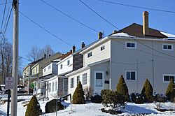
Houses on Somerset Street
|
|

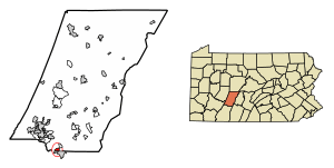
Location of Scalp Level in Cambria County, Pennsylvania.
|
|
| Country | United States |
| State | Pennsylvania |
| County | Cambria |
| Settled | 1835 |
| Incorporated | 1898 |
| Government | |
| • Type | Borough council |
| Area | |
| • Total | 0.66 sq mi (1.71 km2) |
| • Land | 0.66 sq mi (1.71 km2) |
| • Water | 0.00 sq mi (0.00 km2) |
| Elevation | 1,703 ft (519 m) |
| Population
(2010)
|
|
| • Total | 778 |
| • Estimate
(2019)
|
700 |
| • Density | 1,062.22/sq mi (410.16/km2) |
| Time zone | UTC-5 (Eastern (EST)) |
| • Summer (DST) | UTC-4 (EDT) |
| Area code(s) | 814 |
| FIPS code | 42-68104 |
| GNIS feature ID | 1215033 |
Scalp Level is a small town, also called a borough, located in Cambria County, Pennsylvania, in the United States. It's part of the larger Johnstown, Pennsylvania area. In 2010, about 778 people lived there.
Contents
A Look Back in Time
How Scalp Level Got Its Name
The name "Scalp Level" has an interesting story! People say it came from a local farm owner. He told his workers to "scalp them bushes level." This meant to cut down the bushes so the land was flat.
Historic Places in the Area
The Windber Historic District is a special area nearby. It was added to the National Register of Historic Places in 1991. This means it's an important place with a lot of history.
Where is Scalp Level?
Location and Neighbors
Scalp Level is located in the southern part of Cambria County. It sits at coordinates 40.250976 degrees North and -78.839813 degrees West. To the south, it shares borders with the towns of Paint and Windber. These towns are in Somerset County.
Rivers and Roads
The town is in the valley of Paint Creek. This creek flows west and joins the Stonycreek River. The Stonycreek River then flows north to form the Conemaugh River in Johnstown. Johnstown is about 7 miles (11 km) northwest of Scalp Level.
A big four-lane highway, U.S. Route 219, is about 2 miles (3 km) northwest of Scalp Level. This highway goes southwest for 24 miles (39 km) to Somerset. It also goes northeast for 19 miles (31 km) to Ebensburg, which is the main town of Cambria County. Pennsylvania Route 56 goes right through the middle of Scalp Level. It leads southeast for 31 miles (50 km) to Bedford.
Size of the Borough
According to the United States Census Bureau, Scalp Level covers a total area of about 0.66 square miles (1.7 square kilometers). All of this area is land.
People of Scalp Level
Population Over the Years
| Historical population | |||
|---|---|---|---|
| Census | Pop. | %± | |
| 1900 | 450 | — | |
| 1910 | 1,424 | 216.4% | |
| 1920 | 1,690 | 18.7% | |
| 1930 | 1,875 | 10.9% | |
| 1940 | 1,950 | 4.0% | |
| 1950 | 1,756 | −9.9% | |
| 1960 | 1,445 | −17.7% | |
| 1970 | 1,353 | −6.4% | |
| 1980 | 1,186 | −12.3% | |
| 1990 | 1,158 | −2.4% | |
| 2000 | 851 | −26.5% | |
| 2010 | 778 | −8.6% | |
| 2019 (est.) | 700 | −10.0% | |
| Sources: | |||
In 2000, there were 851 people living in Scalp Level. There were 347 households and 234 families. The population density was about 1,368.5 people per square mile (528.4 per square kilometer). Most people living in the borough were White (99.53%).
Age and Gender
The people in Scalp Level were spread out in age. About 22.6% were under 18 years old. About 19.9% were 65 years or older. The average age was 40 years old. For every 100 females, there were about 88.3 males.
Notable People
- Alexander Ratiu: He was an author, a Roman Catholic priest, and a political activist.
See also
 In Spanish: Scalp Level para niños
 | Kyle Baker |
 | Joseph Yoakum |
 | Laura Wheeler Waring |
 | Henry Ossawa Tanner |


