
Scheduled monuments in Nottinghamshire facts for kids
This is a list of scheduled monuments in Nottinghamshire, a county in England. These are special historic places that are protected by law.
In the United Kingdom, a scheduled monument is a very important archaeological site or historic building. It gets special protection to make sure it isn't changed without permission. The Secretary of State for Culture, Media and Sport puts these sites on a list, and English Heritage helps decide which places are important enough. There are about 20,000 scheduled monuments listed across the UK.
Sometimes, a scheduled monument can also be called a listed building. However, English Heritage usually thinks that being a listed building offers better protection for buildings. If a monument is no longer considered important enough, it can be removed from the list.
Nottinghamshire has over 160 scheduled monuments. These include sites from the Roman times, the Middle Ages, and the English Civil War. You can find old buildings, ruins, and archaeological sites here.
Contents
Nottinghamshire's Historic Places
Nottinghamshire is full of amazing historical sites. Let's explore some of them!
Ancient Churches and Priories
Some of the oldest and most beautiful protected sites are churches and priories.
.jpg)
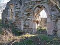
All Saints Church and graveyard in Annesley are the remains of a medieval church from the 13th century. It was left empty when a new church was built in 1874 for the nearby mining village.

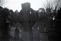
You can find an Anglian high cross in the churchyard of St Helen's Church in Stapleford. This is a very old stone cross from the Anglo-Saxon period.

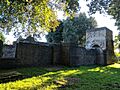
Beauvale Priory in Greasley was a monastery built in 1343 for the Carthusian monks. Sir Nicholas de Cantilupe started it with permission from King Edward III.

Blyth Priory was founded in 1088 by Roger de Busli. It was a home for Benedictine monks. Part of the old priory is now part of Blyth Church.

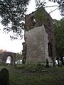
The ruins of Haughton Chapel (St James' church) in Haughton date back to the 12th century. The roof was lost in 1915, leaving it as a beautiful ruin.

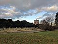
The remains of Lenton Priory can be found in Nottingham. This was once an important church.

Mattersey Priory was a monastery built in 1185 by Roger FitzRalph. It was dedicated to St Helen and built on a gravel island in the River Idle.
.jpg)
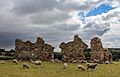
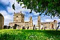
Rufford Abbey was a Cistercian monastery. Today, you can see the old monastery area, water systems, and even older farming fields from before the monastery was built.
.jpg)
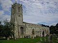
The ruined St Helen's Church in South Wheatley is another protected church site.

The ruins of St Mary's Church in Colston Bassett are also a scheduled monument.

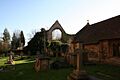
St Wilfrid's Church and churchyard in Kinoulton were abandoned in the late 1700s when the church was moved closer to the village.
Mighty Castles and Forts
Nottinghamshire has many remains of old castles and forts.

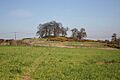
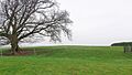
The Annesley motte and bailey castle is a type of early castle with a large mound (motte) and a walled area (bailey).

The Bothamsall motte and bailey castle overlooks the River Meden. It also includes an old hollow way, which is a sunken path from long ago.
.jpg)
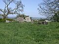
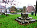
Cranmer's Mound in Aslockton is a motte castle. It also has a special mound for viewing, old fishponds, and old farming patterns in the fields.
.jpg)
Cuckney Castle is another motte and bailey castle. Its low remains can be found near St Mary's Church in Norton Cuckney.

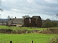
Greasley Castle was once a manor house that Sir Nicholas de Cantelupe turned into a castle in 1340. Greasley Castle Farm now stands on the site.

Newark Castle was built in Newark-on-Trent in the mid-12th century by Alexander, the Bishop of Lincoln. It started as a timber castle and was later rebuilt with stone. After the English Civil War, most of it was taken down, but it was partly restored in the 1800s.

Nottingham Castle is a famous medieval castle built in 1068. In 1651, after the English Civil War, most of its defenses were destroyed, except for the gatehouse and the base of a tower.

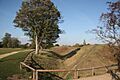
The Slight univallate hillfort at Farnsfield is an Iron Age fort on a hill. You can still see the earthwork bank and ditch. Old pottery, Roman tiles, and even a Bronze Age axe have been found here.
Roman and Ancient Settlements
Nottinghamshire has many sites from the Roman period and even older times.
.jpg)
Creswell Gorge has very old Stone Age sites, including Pinhole Cave, Mother Grundy's Parlour, and Robin Hood's Cave. This deep valley, made of limestone, is on the border of Derbyshire and Nottinghamshire. Its caves were used by people during the last Ice Age, between 43,000 and 10,000 years ago. These caves contain the most northern cave art in Europe!
.jpg)
More of the Creswell Gorge Stone Age sites include Boat House Cave and Church Hole Cave.
- Crococalana Roman town in Collingham was a Roman town that grew around a military fort in the 1st century. It spread along the Fosse Way, an old Roman road, and had defensive ditches.

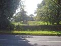
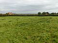
The Margidunum Roman Station is located on the Fosse Way, halfway between Leicester and Lincoln. It was an important Roman camp.

There are two Roman camps at Calverton. While you can't see much above ground today, aerial photos clearly show the buried structures of these camps, which were about 300m by 300m. Roman coins have been found here too.

The Roman camp at Farnsfield also has no standing remains, but excavations have found Roman defensive ditches. The outlines of the camp are visible on aerial photos.
Civil War Defences
During the English Civil War, many defensive structures were built.
- Civil War defences can be found in Coddington, Newark. These were built to protect areas during the war.
- Civil War gun battery at Shelford was a place where cannons were set up to defend against attacks.

The Queen's Sconce in Devon Park, Newark, is a large earthwork built by the Royalist army to defend Newark-on-Trent. It's over 100m by 100m with ramparts (walls of earth) that are 9m high!
Other Interesting Structures

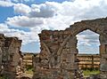
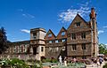
The Archbishop's Palace in Southwell dates from the 14th century. A famous leader named Cardinal Wolsey lived here. It's also where the arrest of King Charles I was made official after he was captured in Southwell.

Beeston Lodge in Clipstone is a 14th-century site. It was a fortified farming community that King Edward II added to Clipstone Park.

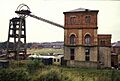
The Bestwood Colliery engine house is the only example of a vertical duplex steam winding engine in the country. It was built in 1873 to help with coal mining, and the pit closed in 1967.

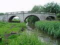
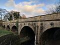
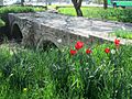
Blyth New Bridge is a very important bridge, built in 1770 by John Carr. It carries the A634 road over the River Ryton.

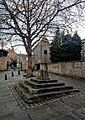
A cross in St Michael's churchyard in Laxton and Moorhouse is another protected site.

King John's Palace in King's Clipstone are the remains of an old royal home from the Middle Ages. Even though it's called "King John's Palace," King John only stayed there for a few days. It was originally built for King Henry II in 1176.
.jpg)
King's Mill Viaduct in Mansfield is a five-arch bridge built in 1819. It was used for a horse-drawn railway that moved stone and lime. It's now a footpath.

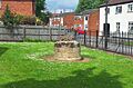
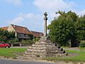
The Market cross at Gringley is a stone cross where a market was allowed to be held since 1252.

Another Market cross can be found in Kirkby in Ashfield.

The Old Trent Bridge was replaced by the current Trent Bridge in 1871.

Papplewick Pumping Station was built between 1881 and 1884 to pump drinking water from the ground to the city of Nottingham.

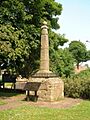
A Standing cross at Collingham is another historic cross.

The Standing cross known as Beaumond Cross in Newark is a 15th-century cross that has been repaired and decorated over the years.

The Standing cross known as Bottom Cross in Linby is also a protected site.

Another cross in Linby is the Standing cross known as Top Cross.
.jpg)
A Standing cross on Church Street, Mansfield Woodhouse is a historic landmark.

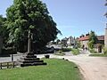
You can find a Standing cross on Upper Broughton village green.
.jpg)
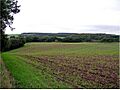
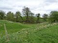
Whimpton Moor medieval village and moated site in Ragnall is the site of an old village that was abandoned. You can still see the earthworks from where the village once stood.
Images for kids
-
Remains of medieval C13th church and graveyard.
-
Anglo-Saxon cross in St Helen's parish churchyard
-
Annesley Castle Motte
-
Archbishop's Palace Ruins
-
Beauvale Priory Remains
-
Beeston Lodge, Clipstone Peel
-
Bestwood Colliery winding engine house & headstocks
-
Blyth New Bridge
-
Blyth Church, which incorporates part of the former priory
-
Bothamsall motte
-
Cranmer's Mound, Aslockton
-
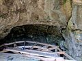
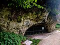
Mother Grundy's Parlour Cave, Creswell Crags
-
Boat House Cave, Creswell Crags
-
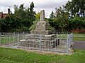
Celtic Type Cross, Laxton Churchyard
-
Cuckney motte and bailey castle
-
Remains of Greasley Castle
-
Haughton Chapel Remains
-
King John's Palace at Clipstone
-
King's Mill Viaduct, Kings Mill Lane
-
Remains of Lenton Priory
-
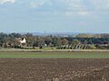
View towards Margidunum
-
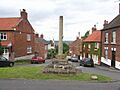
Market Cross, Gringley on the Hill
-
Kirkby Cross, Kirkby in Ashfield
-
Mattersey Priory Ruins
-
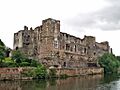
Newark Castle by River Trent
-
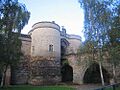
Nottingham Castle gate house
-
Old Trent Bridge
-
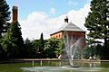
Papplewick Pumping Station
-
Queen's Sconce, Newark-on-Trent
-
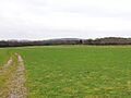
Site of Roman Camp at Calverton
-
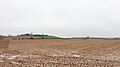
Site of Roman Camp at Farnsfield
-
Rufford Abbey
-
Combs Farm Camp Iron Age Hillfort
-
West tower of the ruined St Helen's parish church
-
Ruins of St Mary's Church
-
St Wilfrid's Graveyard
-
Collingham Cross
-
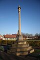
Beaumond Cross
-
Bottom Cross, Linby
-
Top Cross, Linby
-
Standing cross on Church Street, Mansfield Woodhouse
-
Village Green and Cross, Upper Broughton
-
Earthworks of the former village
